English Text:
The fountain of Glauke, a large cubic mass of limestone, was formed when the surrounding bedrock was quarried away. Originally, the fountain was contained within a long limestone ridge running west from Temple Hill. . . . — — Map (db m84823) HM
English Text:
The seven standing columns of the Archaic temple are one of the most prominent landmarks of Corinth. Contrary to one's first impression, however, the view from this point is back of the building. The dedication of the . . . — — Map (db m84826) HM
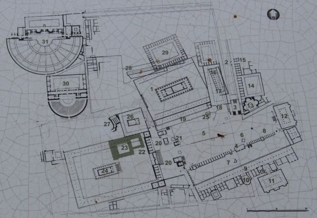
The route of the ancient traveler Pausanias through the Corinthian Forum at the 2nd century A.D., together with the results of the excavations conducted on the site by the American Archaeological School of Athens, give the modern visitor an idea . . . — — Map (db m84840) HM
English Text:
The buildings in the west end of the Roman Forum date from the 1st and 2nd century AD. In contrast to most temples of both Greek and Roman periods in Greece, the temples each stood on a high podium constructed of rubble and . . . — — Map (db m84867) HM
English Text:
The Rostra was a complex marble structure dating from the middle of the 1st century A.D. which dominated the face of the terrace of the Upper Forum at Corinth. It took the form of an open propylon with a n-shaped . . . — — Map (db m84874) HM
English Text:
On the hillside where the Bema of the Roman Forum was later built and alongside a road leading southward to Acrocorinth, a cemetery had been delevoped during the Geometric period (1050 - 720 B.C.)
Later on, during the . . . — — Map (db m84915) HM
English Text:
Propylaie on the Lechaion Road
The Propylaia, the main entrance to the Forum, consisted of three archways; one main and two smaller ones. At the time of Pausanias the gilded bronze chariots of Helios and . . . — — Map (db m84967) HM
English Text:
Peirene is one of the most important topoi in the urban landscape of both Greek and Roman Corinth. Human activity is attested in the area from the Neolithic period, and the first efforts in water management date to the . . . — — Map (db m84991) HM
Saint Paul is also known as the Apostle of the Nations because of his missionary journeys throughout the eastern Mediterranean (46-58 AD) for the dissemination of Christianity. In this context he visited several Greek cities, including Samothrace, . . . — — Map (db m84891) HM
English Text:
The South Stoa, one of the largest porticoed buildings in ancient Greece, was built in the late 4th century B.C., to the south of the race track of Corinth. The excavation of it by the American School of Classical Studies . . . — — Map (db m85076) HM
English Text:
Standing 9.00 meters above the Forum, Temple E occupied as prominent a place in the Roman city as the Temple of Apollo.
In its first phase, the temple had stone foundations, probably with a triple crepis measuring . . . — — Map (db m85084) HM