5 entries match your criteria.
Related Historical Markers
To better understand the relationship, study each marker in the order shown.
By Amanda Hartley, May 11, 2010
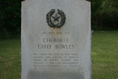
Cherokee Chief Bowles Marker
SHOWN IN SOURCE-SPECIFIED ORDER
| | On this site the
Cherokee Chief Bowles was killed on July 16, 1839 while leading 800 Indians of various tribes in battle against 500 Texans. The last engagement between Cherokees and whites in Texas. — — Map (db m91605) HM |
| | In 1830, John Crane applied to be a part of Joseph Vehlein's colony. Reportedly from Virginia, he was a veteran of the War of 1812. He moved his wife and seven children to what is now Walker County, Texas, in 1834. There, he organized men and became . . . — — Map (db m31567) HM |
| | Driven from Eastern states by white settlers, Cherokee Indians migrated to the East Texas area, becoming established by 1820. In 1822, they unsuccessfully sought title to their land from Mexico.
The years following were ones of an . . . — — Map (db m91604) HM |
| | At this site was the camp of the Army of the Republic of Texas under Generals Edward Burleson, Thomas J. Rusk, Albert Sydney Johnston, Hugh McLeod, Kelsey B. Douglas and Col. Willis H. Landrum just before they engaged Chief Bowles of the Cherokees . . . — — Map (db m91603) HM |
| |
In the vicinity
of Harris' Place
Scouts from the Army of the
Republic of Texas were dispatched
from the present county of Van Zandt
after the battle with Cherokees
and associate tribes July 16, 1839
in which Chief Bowles was . . . — — Map (db m88740) HM |
Apr. 19, 2024