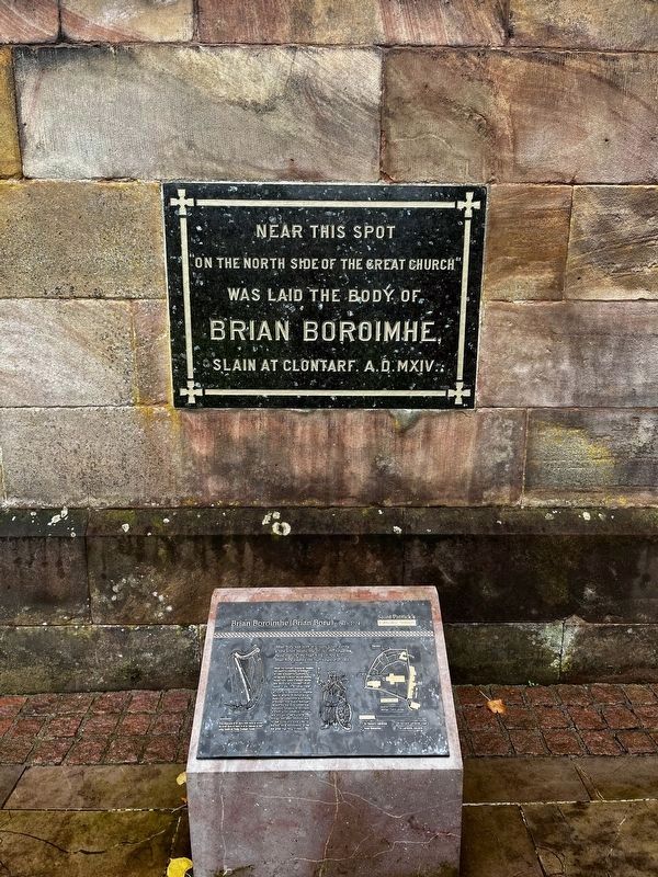
Brian Boru was born in County Clare during
a time when Ireland was divided into kingdoms,
ruled over by one High King or "Ard Rí".
Brian Boru claimed the high kingship in 1001.
When the northern kingdoms resisted
his claim he travelled . . . — — Map (db m211031) HM
Honouring the
bravery and sacrifice of
John Nichol
of Armagn Fire Station, who
gave his life in the line of duty
at Upper English St.
Armagh
27th August
1976 — — Map (db m210140) HM
This memorial is erected
by their fellow countrymen
and comrades to the memory of
the officers, non-commissioned
officers, and men of the
Princess Victoria's Royal
Irish Fusiliers who fell
in the service of their
country during the . . . — — Map (db m210222) WM
During the 5th century St. Patrick is said to have chosen this hill as the place to establish a fortified Christian site.
According to tradition, he
persuaded a local chieftain to
hand over the land and built
his first church here . . . — — Map (db m210113) HM
The Crypt is the most ancient part of St. Patrick's Cathedral and dates back to the 13th century. Up until that time most churches were built
from timber but in 1268, Archbishop O'Scannell
decided to build a new, sturdy stone . . . — — Map (db m210750) HM
Derryadd meaning the long oak wood indicates that this inter-drumlin lake was once fringed by trees. The trees are gone and the lake has reduced in size during the last century. The rise and fall of water levels is a natural process which in recent . . . — — Map (db m196974) HM
Logboats or dugout boats have been used for transport in Ireland since Mesolithic times (7000 BC - 4000 BC) and continued to be used for thousands of years well into the Late Medieval Period 16th and 17th centuries). They were made from hallowed . . . — — Map (db m196977) HM
Trackways were constructed to aid movement across the bog. They range in length from a few hundred meters to several kilometers. As the bogs have grown over the years these trackways have been submerged and preserved at different levels within . . . — — Map (db m196975) HM