[West Historic Marker]:Amherstburg Navy Yard
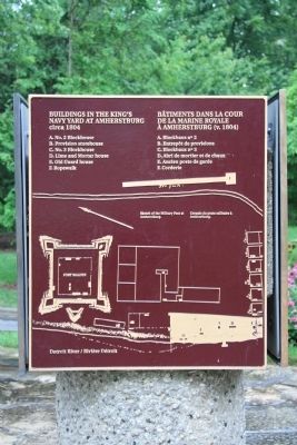
A Navy Yard was built here in 1796 to replace Detroit as the base and supply depot for the Provincial Marine on Lakes Erie and Huron. In 1812 the GENERAL HUNTER and QUEEN CHARLOTTE, built . . . — — Map (db m37552) HM
On Dalhousie Street, on the left when traveling south.
This house, one of the finest remaining examples of domestic Georgian architecture in Ontario, was commenced in 1816 and completed about 1819, by Robert Reynolds, the commissary to the garrison at Fort Malden. Bellevue was also the home of his . . . — — Map (db m103677) HM
Near Laird Avenue South just south of Elm Avenue, on the right when traveling south.
Boblo Island
For many centuries the island you see in front of you was used for hunting and fishing by First Nations people. Called Île aux Bois Blancs by the French, Boblo Island's key location made it a site for . . . — — Map (db m71185) HM
Near Laird Avenue South just south of Elm Avenue, on the right when traveling south.
Brick Officers' Guard Room
and Staff Sergeant's Quarters
(1839)
Poste de garde des officiers en
briques et quartiers du sergent
de l'etat-major (1839) — — Map (db m71220) HM
On Front Road South (County Route 20) south of Dalhousie Street, on the left when traveling south.
On January 9, 1838, a force of Canadians and Americans sympathizing with Mackenzie's rebellion, sailed from United States territory and landed on Bois Blane Island. The schooner "Anne," supporting the invasion, cruised along the Canadian mainland . . . — — Map (db m37246) HM
On Front Road South (County Route 20) close to Dalhousie Street, on the left when traveling south.
Near this site stood the house erected in 1784 by Matthew Elliott. Born in Ireland, he emigrated to the American Colonies in 1761, and during the Revolution served with the British forces as a captain in the Indian Department. He was an Indian agent . . . — — Map (db m37286) HM
Near Laird Avenue South just south of Elm Avenue, on the right when traveling south.
Connection to Town
Fort Malden (originally called Fort Amherstburg) was the anchor of the town, which grew to the south. In this view, you are looking past the parade grounds of the fort (now a park) down Dalhousie Street . . . — — Map (db m71192) HM
Near Laird Avenue South just south of Elm Avenue, on the right when traveling south.
Detroit River Heritage
This river not only forms the border between two great nations, but is also a vital transportation artery into the upper Great Lakes. Imagine the vessels that have travelled on it … First National canoes, . . . — — Map (db m71160) HM
On Laird Avenue South south of Elm Avenue, on the right when traveling south.
The post was begun by the Royal Canadian Volunteers in 1796 to replace Detroit and to maintain British influence among the western Indians. As the principal defense of the Detroit frontier in 1812, it was here that Isaac Brock gathered his forces . . . — — Map (db m34353) HM
Near Laird Avenue South just south of Elm Avenue, on the right when traveling south.
Fort Defences
In front of you is a recreated piece of the fort's palisade, a vertical wall of sharpened logs. This wall surrounded the fort, linking the four diamond-shaped corner projections, called bastions. Around each . . . — — Map (db m71173) HM
Near Laird Avenue South just south of Elm Avenue, on the right when traveling south.
Fort Malden Points of Interest • Fort Malden Points d'intérêt
(1) Visitor Centre
1939
Centre d'accueil
1939
(2) Military Pensioner's Cottage
circa 1851 (Restoration) . . . — — Map (db m71278) HM
Near Laird Avenue South just south of Elm Avenue, on the right when traveling south.
Indian Council House
Two hundred years ago a small building stood about 100 metres north of here, close to the water's edge. This was where meetings took place between the representatives of the British government and those of . . . — — Map (db m71170) HM
On Ramsay Street south of Gore Street, on the left when traveling south.
Born about 1750 in Fermanagh County, Ireland, Caldwell emigrated to Pennsylvania in 1773. During the American Revolution he served with the British forces as a captain in Butler's Rangers at Niagara and Detroit. In 1784 he obtained land near the . . . — — Map (db m37291) HM
Near Laird Avenue South close to Elm Avenue, on the right when traveling south.
Born at Queenston in Upper Canada, John Richardson served as a volunteer at Fort Malden during the War of 1812 and was taken prisoner by the Americans at Moraviantown. He was released at war's end, retired on half-pay in 1818, and spent most of the . . . — — Map (db m76737) HM
Near Laird Avenue South just south of Elm Avenue, on the right when traveling south.
Pensioner's Cottage
This cottage was built in the early 1850s for a retired soldier and his family. About 85 of these homes were constructed just east of the Fort, and leased at a modest rate to veteran soldiers in return for light . . . — — Map (db m71167) HM
Near Laird Avenue South just south of Elm Avenue, on the right when traveling south.
Privy
The foundations in front of you are from a communal privy (toilet) for enlisted men and their families that stood here in 1840. The women and children had a small room - the soldiers made do with an open structure offering . . . — — Map (db m71221) HM
Near Laird Avenue South just south of Elm Avenue, on the right when traveling south.
Shoreline Breakwall
Over time, the force of water and ice has eroded the river bank, creating the need to stabilize the shore. Parks Canada, the Essex Region Conservation Authority (ERCA) and Environment Canada partnered to . . . — — Map (db m71161) HM
On Front Street South (Provincial Highway 20) south of Bingham Road, on the left when traveling south.
Girty's life crossed cultural boundaries between native and white societies on the frontier of American settlement. In 1756 his family was captured by a French-led native war party in Pennsylvania. Simon was adopted by the Seneca, then repatriated . . . — — Map (db m34688) HM
On Front Street North (Provincial Highway 20) north of North Side Road, on the right when traveling south.
In the War of 1812, the first engagement in Canada involving British and American forces in significant numbers occurred here on the Canard River. On July 12, 1812, Brigadier-General William Hull invaded Canada and encamped near Sandwich. British . . . — — Map (db m34336) HM
Near Laird Avenue South just south of Elm Avenue, on the right when traveling south.
Strategic Location
A deepwater channel between here and Boblo Island brings ships close to shore, a fact dramatically illustrated when a north-bound lake freighter passes by. This was why Fort Amerstburg was originally located . . . — — Map (db m71191) HM
On Laird Avenue South south of Elm Avenue, on the right when traveling south.
Tradition has it that the Indian leader Tecumseh stood upon this stone to deliver a final address to the British at Amherstburg after the Battle of Lake Erie. Donated in 1939, it originally stood near the corner of Dalhousie and Gore Streets. In his . . . — — Map (db m34412) HM
In September 1813 the British squadron under R. Barclay sailed from Amherstburg to collect desperately needed food supplies. They were met by the larger, more heavily armed American squadron commanded by O. Perry. The British had the initial . . . — — Map (db m37707) HM
The office for the Commissariat Department was built in 1831 near the government wharf and storehouse. Commissary officials purchased from local contractors the flour, beef, straw and firewood used by troops. They also managed Fort Malden's . . . — — Map (db m37356) HM
On Dalhousie Street north of Richmond Street, on the right when traveling south.
Part of an ancient network of Indian paths, the Great Sauk Trail, as it came to be known, extended from Rock Island in present-day Illinois to the Detroit River. It played a significant role in the communications between the native peoples in the . . . — — Map (db m36976) HM
Near Laird Avenue South just south of Elm Avenue, on the right when traveling south.
The Site Over Time
Today the site looks very different than it would have 170 years ago, when Fort Malden was at its height. Almost all the buildings from that period have been lost, and most of the ditch and wall that encircled . . . — — Map (db m71174) HM
On Front Road North north of County Route 10, on the right when traveling south.
This area was once the home of the Wyandot, remnants of the Huron, Neutrals, and Petuns who were dispersed by the Iroquois in the 1640's. Some eventually reunited and settled along the Detroit River, where they became known as the Hurons of Detroit, . . . — — Map (db m37340) HM
Middle Island
Middle Island is the most southern piece of land in Canada. Only a few metres from the Canada-US border, the tiny 22-hectare island is part of the western Lake Erie archipelago. Migrating birds and insects use the island to . . . — — Map (db m124119) HM
Near Lower Thames Lane just north of Harbour Drive when traveling north.
Construction of this Lighthouse by the Oartier family in 1818 and its predecessor. A frame structure destroyed by fire in the latter years of the War of 1812. Established an enduring landmark at the river mouth and a dynasty by the Oartler family as . . . — — Map (db m198365) HM
On Banwell Rd, 1.4 kilometers north of County Rd 42, on the left when traveling north.
Beginning in the 1830s, at least 30 families fleeing enslavement and racial oppression in the United States settled in the Banwell Road area in Sandwich East. They had the opportunity to purchase land through two Black-organized land settlement . . . — — Map (db m90183) HM
On Sandwich Street West just north of Brock Street, on the right when traveling north.
When the British withdrew from Detroit in 1796, they transferred the courts of the Western District to Sandwich (Windsor). An abandoned blockhouse, relocated from Chatham, served briefly as the court house and gaol until fire destroyed it in 1797. . . . — — Map (db m198382) HM
On Ouellette Avenue at Viale Udine, on the right when traveling north on Ouellette Avenue.
Front - In English
Windsor is the oldest known site of continuous settlement in Ontario. The government of New France, anxious to increase its presence on the Detroit River, offered land agricultural settlement on the south shore in 1749. . . . — — Map (db m37343) HM
On Riverside Drive East west of Walker Road, on the left when traveling east.
Massachusetts born, Hiram Walker had by the 1850s become a successful general merchant, distiller and grain dealer in Detroit. After Michigan adopted prohibition in 1855 he acquired land across the river in Canada where he established a distillery . . . — — Map (db m37377) HM
On 2072 Riverside Drive East west of Walker Road, on the left when traveling east.
On July 4, 1812, Brigadier-General William Hull, commander of the North Western Army of the United States, landed with about 2,000 men near this site. He issued a proclamation stating that he came here to liberate Canada from oppression. The British . . . — — Map (db m34302) HM
On Riverside Drive West at Huron Church Road, on the right when traveling south on Riverside Drive West.
In 1728 a mission to the Huron Indians was established near Fort Pontchartrain (Detroit) by Father Armand de la Richardie, S.J. The mission was moved to Bois Blane Island and the adjacent mainland in 1742. In 1747 it was destroyed by disaffected . . . — — Map (db m37386) HM
On Riverside Drive West north of Askin Avenue, on the right when traveling west.
In the year 1782 the Huron First Nation gave Montreal Point to the Diocese. The Jesuit Fathers constructed the Assumption Parish in 1787, the first Roman Catholic Parish west of Montreal, Quebec. Today the park, named Assumption, is owned and . . . — — Map (db m37389) HM
On University Avenue East at Freedom Way, on the right when traveling east on University Avenue East.
This armoury was named after Major Fred Tilston, a true military hero of this community. Maj. Tilston, a member of the Essex Scottish, was awarded the Victoria Cross, the highest award for bravery, for his exploits at the Battle of Hochwald Forest . . . — — Map (db m42292) HM
On Riverside Drive East at Riverside Avenue, on the right when traveling west on Riverside Drive East.
Served as the main navigational aid for the Great Lakes mariners using the Lake Erie Pelee Passage from 1902 to 1975.
The lighthouse was re-erected by Dean Construction Co. Ltd. on the present site as a gift to the City of Windsor.
In honour . . . — — Map (db m198379) HM
On 254 Pitt Street West, 0.2 kilometers east of Dougall Avenue, on the right when traveling west.
Early on December 4, 1838 a force of about 140 American and Canadian supporters of William Lyon MacKenzie crossed the river from Detroit and landed about one mile east of here. After capturing and burning a nearby militia barracks, they took . . . — — Map (db m37172) HM
On Sandwich Street at Ojibway Parkway, on the right when traveling south on Sandwich Street.
Confident of victory, General Hull had invaded Canada in July 1812, but failed to take advantage of his early success and the demoralization of the defenders. Fear of the Indians then rallying to the British cause and an inability to maintain supply . . . — — Map (db m34321) HM
The Detroit River is unique in Canada, the United States and indeed, the world. Its shores embrace the largest metropolitan area on any international border - but rather than separating communities, the river connects them culturally and . . . — — Map (db m37378) HM
On Pitt Street West west of Ferry Street, on the right when traveling west.
This house and adjacent farmland were the property of François Baby (1763-1856), first member for Kent in the Legislative Assembly of Upper Canada (1792-96), militia officer and Assistant Quarter Master General during the War of 1812. When the . . . — — Map (db m34303) HM
On Riverside Drive E at Gayeau Street on Riverside Drive E.
The main line of “The Great Western”, from Niagara Falls through Hamilton and London to Windsor, was opened in 1854. The company extended its line from Hamilton to Toronto in 1855, from Komoka to Sarnia in 1858, and from Glencoe to . . . — — Map (db m100728) HM
On Ouellette Avenue at Viale Udine, on the right when traveling north on Ouellette Avenue.
The Rt. Hon. Gray represented the west side
of Windsor in the House of Commons
from June 1962 to January 2002.
He was elected thirteen consecutive times
- a record - and set another record for continuous days
of service in the House of . . . — — Map (db m37496) HM
Shortly after the founding of Detroit in 1701 a village of Ottawa Indians was established on the south shore of the river in this vicinity and its inhabitants lived on friendly terms with the French garrison and settlers. However after the British . . . — — Map (db m36944) HM
From the early 19th century until the American Civil War, settlements along the Detroit and Niagara rivers were important terminals of the Underground Railroad. White and black abolitionists formed a heroic network dedicated to helping free and . . . — — Map (db m37379) HM
On Ferry Street at Chatham Street West, on the left when traveling north on Ferry Street.
Born in Delaware to free African American parents, Mary Ann Shadd was an experienced teacher, abolitionist, and author prior to arriving in Windsor in 1851. Here, Shadd established an integrated school. Her 1852 monograph, a Plea for Emigration . . . — — Map (db m240809) HM