Marker Logo HMdb.org THE HISTORICAL
MARKER DATABASE
“Bite-Size Bits of Local, National, and Global History”


2 entries match your criteria.  


Historical Markers in Central Okanagan, British Columbia

 
Father Jean-Charles-Jean-Baptiste-Félix Pandosy (1824-1891) image, Touch for more information
Okanagan Historical Socity (public domain)
Father Jean-Charles-Jean-Baptiste-Félix Pandosy (1824-1891)
1 British Columbia, Central Okanagan, Kelowna, South Pandosy - K.L.O. — Father Pandosy O.M.I.
On Benvoulin Road, 0.1 kilometers north of Casorso Road, on the right when traveling north. Reported missing.
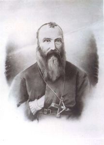
Father Pandosy, an Oblate priest, ministered to natives and white in widely separated parts of British Columbia for over 30 years, until his death in 1891. His mission, with its church, school and farms established in 1859-60 on this site, formed . . . Map (db m187909) HM
2 British Columbia, Central Okanagan, Peachland — The Okanagan Mountain Fire of 2003
On Okanagan Highway (Provincial Highway 97) 0.2 kilometers south of Hardy Street, on the left when traveling south.
Directly across Lake Okanagan, on August 16, 2003, lightning struck a tree at Squally Point. The ensuing blaze consumed over 25,000 hectares as it spread to Kelowna, Myra Canyon, and Naramata. More than 33,000 people were evacuated and 238 homes . . . Map (db m187982) HM


CeraNet Cloud Computing sponsors the Historical Marker Database.
This website earns income from purchases you make after using our links to Amazon.com. We appreciate your support.
Paid Advertisement
Apr. 24, 2024