On Crowsnest Highway (Provincial Highway 3) at Boundary Smelter Road, on the right when traveling east on Crowsnest Highway.
Although prospectors like "Jolly Jack” Thorton worked this area during the 1860s, Boundary Falls was not settled until the 1890s, when a new breed of miners flooded the district. Surrounded by mining properties, the Boundary Falls Smelter (also . . . — — Map (db m187917) HM
On British Columbia 395, 0.1 kilometers east of Crowsnest Highway (Provincial Highway 3), on the left when traveling east.
Cascade came into being during the late-1890s as a bustling railway construction town claiming 17 hotels at its height. Its location along the Canada-U.S. border proved strategic for mining, freighting, and hydro-electricity. The early development . . . — — Map (db m187915) HM
On Crowsnest Highway (Provincial Highway 3) 2 kilometers west of Wilgas Lake Rest Area, on the left when traveling west.
In 1900, the CPR's Columbia & Western Railway penetrated the formidable mountains between Nelson and Midway, connecting the Boundary district to East Kootenay coalfields and beyond. Eholt, at the summit between Grand Forks and Greenwood, became the . . . — — Map (db m187908) HM
On Crowsnest Highway (Provincial Highway 3) 3.4 kilometers west of Stewart Creek Road, on the left when traveling west.
Doukhobors arrived in the Kootenay Boundary area in 1908. Persecuted in Russia for rejecting church rituals and military service, they were derisively named Doukhobors, or ‘Spirit Wrestlers’. Finding refuge in Canada, these Christian pacifists . . . — — Map (db m187884) HM
On Smelter Viewpoint at Butte Avenue, on the right when traveling south on Smelter Viewpoint.
During the prosperous years of the late 1890s, this street was one of the busiest thoroughfares in the province. Little wonder, for in those years copper was king, and Greenwood — incorporated as a city in 1897 — was the capital of the copper-rich . . . — — Map (db m187914) HM
On Smelter Viewpoint at Butte Avenue, on the left when traveling north on Smelter Viewpoint.
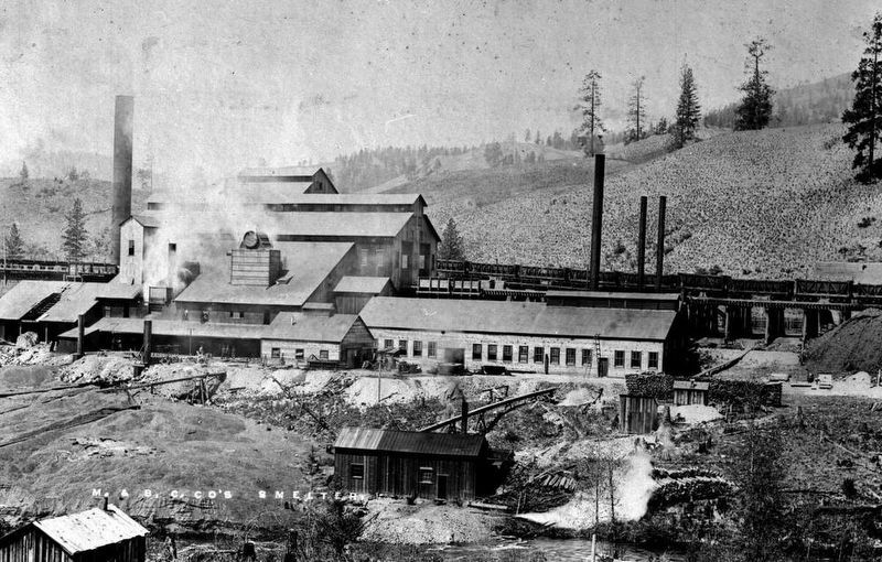
In this wilderness of rugged mountains, ore was first found in the late 1880's. Further prospects led to the building of a large smelter by the B.C. Copper Co. From 1901, copper, gold and silver poured from its furnaces. Fed by the great Motherlode . . . — — Map (db m187998) HM
On Crowsnest Highway (Provincial Highway 3) just west of Beamish Street, on the right when traveling west.
When the Midway to Hope section of the “K.V.” was completed in 1916 and joined with existing short lines, it formed a direct southern railroad from Alberta to the Pacific Coast. An important factor in advancing the economy of southern B.C., it has . . . — — Map (db m187941) HM
On 5th Avenue at Florence Street, on the right when traveling east on 5th Avenue.
Proximity to Boundary Creek mines, and excellent climate, water and soil convinced Midway promoters of a bright future as a "railway and residential town.” The Columbia & Western Railway reached Midway in 1900; five years later, the Vancouver, . . . — — Map (db m187938) HM
On Provincial Highway 3B at Paterson-Trail Highway (Provincial Highway 22), on the right when traveling west on Provincial Highway 3B.
You have entered the crater of an ancient volcano rich in minerals. The waste dumps are the remains of famous Rossland mines staked in 1890 by prospectors passing on the near-by Dewdney Trail. From these fabulously rich workings came 6,000,000 tons . . . — — Map (db m187953) HM
Near Paterson-Trail Highway (Provincial Highway 22) 1.1 kilometers north of King George Park Road.
"A travel route north of the boundary line" was the cry in the 1860's when gold was found in the Kootenays. Edgar Dewdney built such a route — a trail 360 miles long from Coast to Rockies.
For over two decades it carried miners, settlers, gold . . . — — Map (db m187959) HM