At 582 feet, Clarkes Gap, up the hill to your left, was the highest point on the Washington & Old Dominion Railroad. The stone bridge dates from the 1870s, when the tracks were completed to Clarkes Gap. The station stood on the site where you are . . . — — Map (db m2031) HM
Monday, August 8, 1864, was a hot and sultry day. Capt. John McMenamin of the 15th New York Volunteer Cavalry and Capt. James Fleming of the 16th New York Volunteer Cavalry had stopped at St. Mary's Church on the Ox Road (now Fairfax Station . . . — — Map (db m186) HM
The 1860 Alexandria, Loudoun, and Hampshire Railroad station at this junction was called a flag stop - a passenger would step out and flag down the train to catch a ride. At the time that the 1900 picture to the left was taken, the railroad was . . . — — Map (db m24791) HM
You are standing across the street from land that Harriet Brice, a “free woman of color,” purchased in 1864. Together with her husband, George Brice, she struggled to farm the property during the Civil War. Although she had gained her freedom . . . — — Map (db m206332) HM
After no luck in western goldmines Walter H. Erwin in 1852 bought two acres for $100 (part of 1729 248-acre Trammel grant). Built frame tavern on this site which became a landmark on Leesburg Pike. 1861 sketch shows it with a verandah and green . . . — — Map (db m2874) HM
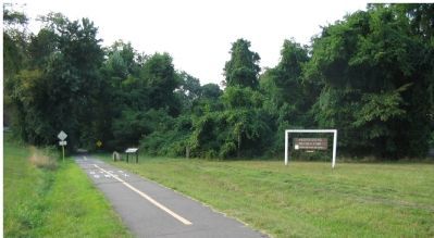
The 100-ft wide W&OD has been called "the skinniest park" in Virginia. But it is also one of the longest parks, 45 miles of paved trail for walking, running, cycling and skating and more. Built on the roadbed of the former Washington & Old . . . — — Map (db m214558) HM
This monument commemorates the inhabitants of the Tinner Hill area who risked their livelihoods and their lives to defend the principles of the U.S. Bill of Rights. Constructed by the Tinner Hill Heritage Foundation Dedicated June 5, 1999 . . . — — Map (db m4203) HM
Famous ordinary believed to be part of Federal-style mansion built on 145 acres bought for $291 in 1787 by James Wren (part of 1742 208-acre G. Harrison grant). Lying north of Alexandria-Leesburg Rolling Road, tavern operated 1789-1815 under James . . . — — Map (db m2842) HM
Noted for his cratsmanship on the first Falls Church and other structures for prominent landowners, to include the Washington family. Richard Blackburn (1710-1757) built Rippon Lodge as his main estate house circa 1747. Richard's son, Thomas . . . — — Map (db m131560) HM
Original Federal Boundary Stone
District of Columbia
Placed 1791-1792
Protected by Ruth Brewster Chapter
Daughters of the American Revolution
1916 — — Map (db m154790) HM
Glebe Road & Ballston
Glebe Road, which passes this site, is one of Northern Virginia's oldest transportation arteries. Its recorded history dates to ca. 1740 when it was known as the "Road to the Falls," taking travelers by land from the . . . — — Map (db m145145) HM
Peyton Anderson of the Rappahannock Cavalry was severely wounded on picket duty 122 ft. N.W. of this spot May 27, 1861.
The first soldier of the South to shed his blood for the Confederacy. — — Map (db m129267) HM WM
Nearby once stood Fort Buffalo. This
earthwork fortification was built by the 21st New York Infantry of the Union army in 1861 and named for the troops’ hometown. During the Civil War, a concentration of forts existed in the Seven Corners section . . . — — Map (db m7399) HM
The Mass in the early 1870's was celebrated in the home of the Sewall family, known as Walnut Hill, on South West Street. In 1874 the mission of Falls Church was established by the Bishop of Richmond and administered by priests from Saint Mary's . . . — — Map (db m144996) HM
Pimmit Run is a stream that runs from the Pimmit Hills neighborhood in Falls Church and joins the Potomac River immediately south of Chain Bridge. The mouth of Pimmit Run provided Native Americans and settlers access to fresh water and fishing, the . . . — — Map (db m59708) HM
The 100-ft wide W&OD has been called "the skinniest park" in Virginia. But it is also one of the longest parks, 45 miles of paved trail for walking, running cycling and skating and more. Built on the roadbed of the former Washington & Old . . . — — Map (db m131543) HM
In the late 1950s, the Northern Virginia Planning District Commission and a group of citizens from several local jurisdictions came together to protect Northern Virginia's rich heritage of woods, meadows, lakes and streams from the threat of . . . — — Map (db m197049) HM
The 100-ft wide W&OD has been called "the skinniest park" in Virginia. But it is also one of the longest parks, 45 miles of paved trail for walking, running, cycling and skating and more. Built on the roadbed of the former Washington & Old Dominion . . . — — Map (db m115846) HM
The Washington & Old Dominion Railroad had competition. In 1904 the Washington, Arlington, & Falls Church Railway began service from Washington, D.C., to Vienna, Virginia, along a route parallel to the W&OD.
Besides offering passengers the . . . — — Map (db m214397) HM
The 100-ft wide W&OD has been called "the skinniest park" in Virginia. But it is also one of the longest parks, 45 miles of paved trail for walking, running, cycling and skating and more. Built on the roadbed of the former Washington & Old . . . — — Map (db m214395) HM
The 100-ft wide W&OD has been called "the skinniest park" in Virginia. But it is also one of the longest parks, 45 miles of paved trail for walking, running, cycling and skating and more. Built on the roadbed of the former Washington & Old Dominion . . . — — Map (db m143133) HM
The Rev. James Huckins, a visiting Baptist missionary agent, met with nine charter members in the home of Thomas Borden to organize a Baptist church in Galveston on January 30, 1840. Borden's brother Gail Borden, Jr., and sister-in-law Penelope . . . — — Map (db m180029) HM
Before the American Revolution, the Church of England was the established church of Virginia and part of the colonial government. For administrative purposes, the colony was divided into "parishes" and all residents paid taxes to maintain church . . . — — Map (db m115716) HM
The house of moderate cost is not only America's major architectural problem but the problem most difficult for her major architects.
- Frank Lloyd Wright, 1936
At the beginning of the American Civil War in mid-1861, Union General Irvin McDowell, Commander, Army of Northeastern Virginia, knew that his army lacked an adequate supply of wagons. The Alexandria, Loudoun, and Hampshire Railroad (today's W&OD . . . — — Map (db m24864) HM
Arlington County in 1921
This 1921 aerial photograph shows the immediate surroundings and transportation networks of both the streetcar line and roads from Clarendon from Ballston. The Washington-Virginia Railway, successor to the Washington, . . . — — Map (db m145151) HM
In memory of
David F. Strickler
Citizen of Falls Church, VA
CPL Co B 14 Inf 4 Inf Div
Killed in Action - Vietnam
Bronze Star
Purple Heart
21 February 1947 - 29 April 1968
Dedication 7 June 1968
Remembrance 29 May . . . — — Map (db m184088) WM
Lucy Carter was a brave local woman with deep family roots.
A multiracial family named Carter lived near here in the 19th century. Lucy Carter was a free woman of color, but because of manumission laws passed in the 1800s, she had to . . . — — Map (db m198192) HM
Clara Shorts Adams and Robert Adams conveyed a quarter-acre to the Falls Church School District of Fairfax County in 1898 for the purpose of educating African American children. The one-room "Colored School Building at Seminary" was the first . . . — — Map (db m167217) HM
Early in the U.S. Civil War, Mason's Hill was strategically important because of its high elevation and good views of nearby thoroughfares, Columbia Turnpike, and Little River Turnpike. Mason's Hill, Munson's Hill, and Bailey's Crossroads were . . . — — Map (db m205386) HM
Charles was born in Rochester, New York. At the early age of thirteen he entered the provincial seminary of St. Francis near Milwaukee. He graduated in 1864 and then entered the American College at Louvain, Belgium. There he earned two divinity . . . — — Map (db m39937) HM
Fort Ethan Allen was a repeating station, transmitting messages back and forth to other nearby stations.
A series of signal stations linked the forts of the Defenses of Washington. The soldiers who relayed secret messages from station to . . . — — Map (db m129238) HM
Few facilities in Northern Virginia offer the variety of recreation options presented by Cameron Run Regional Park. Lying adjacent to the Capital Beltway in Alexandria, Cameron Run is serenity carved among glass and metal — a day long vacation of . . . — — Map (db m197469) HM
William Fairfax:
• fought in Spain for Queen Anne;
• was a member of the Royal Navy;
• served as Governor of New Providence, Bahama Islands,
• served as an agent to manage, the Northern Neck Proprietary;
• was a Vestryman of Pohick . . . — — Map (db m35116) HM
W & OD Trail.
The 100-foot-wide Washington and Old Dominion Railroad Regional Park (W&OD Trail) features a 45-mile asphalt trail for walking, running, skating, bicycling and other activities and a 33-mile parallel, gravel bridle path for . . . — — Map (db m2406) HM
Beauty, conservation, education and discovery flourish throughout the year at this 95-acre botanical garden of large ornamental display gardens and unique native plant collections. Walking trails, lakes, more than 20 varieties of cherry trees, . . . — — Map (db m198006) HM
137 entries matched your criteria. Entries 101 through 137 are listed above. ⊲ Previous 100
* Inflectional forms of words are their plurals, singulars, and possessives as well as gramatical tenses and similar variations.