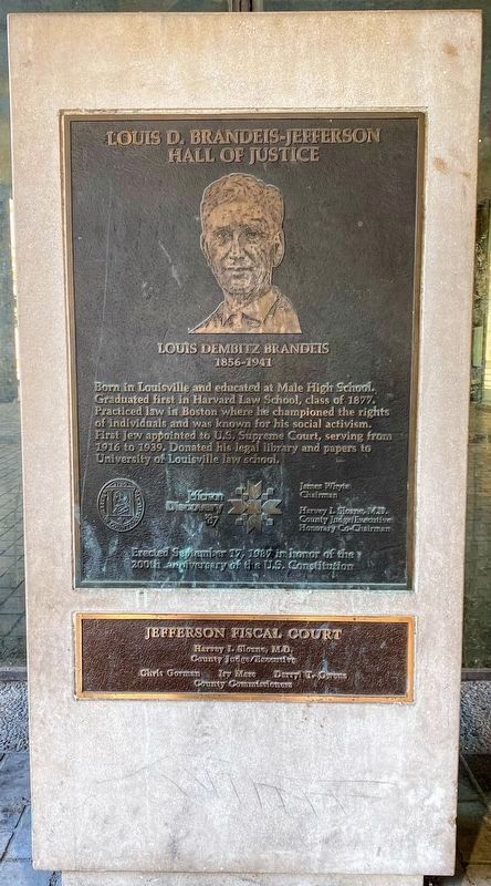
Born in Louisville and educated at Male High School. Graduated first in Harvard Law School, class of 1877. Practiced law in Boston where he championed the rights of individuals and was known for his social activism. First Jew appointed to U.S. . . . — — Map (db m179129) HM
Jefferson High School Jefferson High School opened in 1956 as a junior high and high school for African-American students of Beech Island, Belvedere, Graniteville, Jackson, Langley-Bath-Clearwater, and North Augusta, with Herman W.W. Fennell . . . — — Map (db m31675) HM
Native American Roots
Long before the settlement of Nashville, Native Americans had strong ties to this land. Archaeological Investigations have returned varied and numerous prehistoric artifacts from the Middle Woodland Period (200BCE - . . . — — Map (db m206501) HM
Though enslaved, Sally Hemings helped shape her life and the lives of her children, who got an almost 50-year head start on emancipation, escaping the system that had engulfed their ancestors and millions of others. Whatever we may feel about . . . — — Map (db m231286) HM
Such relationships ranged from acknowledged affairs that...were familial in every sense but a legally recognized one to brutal acts of rape and sexual assault where slave owners showed the inhumanity for which slavery was notorious. . . . — — Map (db m231159) HM
What you see here is a reconstruction of the North Terrace wing. The original wing, built 1801-05, housed Jefferson's carriages and the horses and carriages of visitors; most of Jefferson's horses were stabled at the east end of Mulberry Row. Horses . . . — — Map (db m100469) HM
The Louisiana Purchase of 1803 was the first large step for the United States to complete its calling of Manifest Destiny to expand from sea to shining sea. Though national attention focused on east-west travel it would be another 114 years . . . — — Map (db m188373) HM
“...upon occasion of the prevalence of the yellow fever...Samuel A. Mudd devoted himself to the care and cure of the sick and interposed his courage and skill to protect the garrison...from peril and alarm, and thus...saved many valuable lives . . . — — Map (db m9305) HM
The Lanier House, for decades Macon's premiere hotel, opened on June 12, 1850 at this location. Macon native and poet Sidney Lanier was a member of the inn-keeping family. With additions the hotel stretched 135 feet on Mulberry Street with a cast . . . — — Map (db m130961) HM WM
Davis' Division - McCook's Corps
Brigadier General Jefferson C. Davis
(September 19th, 1863, 2 to 5 p.m.)
1st Brigade - Colonel P. Sidney Post.
2d Brigade - Brigadier General William P. Carlin
3d Brigade - Colonel Hans C. Heg. . . . — — Map (db m102115) HM
Traveling south ahead of her husband, Confederate President Jefferson Davis, First Lady Varina Davis and the Davis's four children departed Abbeville, South Carolina in late April 1865. Escorting them were the President's personal secretary, Burton . . . — — Map (db m224106) HM
Confederate President Jefferson Davis, various government officials, and a 2,500-man cavalry escort departed Abbeville, South Carolina, before midnight on May 2, 1865. Included were several Confederate cabinet members, the President's personal . . . — — Map (db m224116) HM
After capturing Confederate President Jefferson Davis, his family, staff and escort just north of Irwinville, Georgia near dawn on Wednesday, May 10, 1865, Union Lieutenant Colonel Benjamin D. Pritchard and his 135-man detachment of the 4th Michigan . . . — — Map (db m174535) HM
Pulaski County was created in 1808 and named for Count Casimir Pulaski. He was a Polish born Brigadier General and hero during the American Revolution who was mortally wounded at Savannah, Georgia in 1779. Hawkinsville became the county seat in . . . — — Map (db m174537) HM
Text on the first tablet:
Davis' Division - McCook's Corps
Brigadier General Jefferson C. Davis
September 20th, 1863.
1st Brigade - Colonel P. Sidney Post. Guarding Trains.
2nd Brigade - Brigadier General . . . — — Map (db m107404) HM
Davis' Division - McCook's Corps
Brigadier General Jefferson C. Davis
September 19th, 1863, Noon.
1st Brigade - Colonel P. Sidney Post.
2d Brigade - Brigadier General William P. Carlin
3d Brigade - Colonel Hans C. Heg.
The . . . — — Map (db m120378) HM
On Thursday, November 24, 1864, the 14th and 20th Corps of Union Major General William T. Sherman's army began entering Washington County. By November
26th the 28,000 soldiers of the two corps arrived in Sandersville, marching on separate roads . . . — — Map (db m103235) HM
Secession sentiment was strong on Thursday, December 15, 1860, when a rally in Washington, Georgia raised a new flag over the cupola of the Wilkes County Courthouse located in the center of the town's square. It was a blue banner with a large . . . — — Map (db m200043) HM
Mt. Vernon resident Bill Steffy constructed this replica of the Thomas Atkins Blacksmith Shop in 1993. The former Atkins Blacksmith Shop was located in Waltonville, Illinois. any of the contents of the Blacksmith Shop are original to the Thomas . . . — — Map (db m239808) HM
Jefferson County is home to a great boulder-strewn canyon that sunlight can only penetrate at high noon. Moss and ferns cling to the cliffs along Clifty Creek where Big Clifty Falls drops 60 feet in its run to the Ohio River. In 1846 the county . . . — — Map (db m238918) HM
Master carpenter James Dinsmore oversaw construction of this Ice House to Jefferson's design in 1802. Enslaved and hired workers filled it each year between November and February with ice cut from the nearby Rivanna River, shallow ponds, or snow . . . — — Map (db m68174) HM
Every article is made on his farm; his negroes are cabinet makers, carpenters, masons, bricklayers, smith, etc. Duc de La Rochefoucauld Liancourt, 1796
You are standing on Mulberry Row, a road once lined with more . . . — — Map (db m68171) HM
Panel 1 Jefferson introduced mechanized cloth production to his plantation when trade embargoes and looming war cut off the supply of imported British cloth. In 1811, he hired William McLure, a free white artisan and "a very ingenious man," . . . — — Map (db m68175) HM
After Jefferson's death in 1826, his heirs sold his property, including his slaves, to pay his debts. Naval officer Uriah Phillips Levy, who admired Jefferson for his support of religious liberty, purchased Monticello in 1834 to preserve it. This is . . . — — Map (db m80808) HM
Jefferson City witnessed many dramatic events during the Civil War. In the early months of the war, Secessionists and Unionists engaged in a tense contest for dominance. It ended in the hasty flight of the elected pro-Southern government and its . . . — — Map (db m62402) HM
Isaac Granger Jefferson worked the forge in the original building on this site, which housed a "storehouse for iron" in 1796, a short-lived tinsmithing operation, a small nail-making shop, and also served as quarters for enslaved people. The use . . . — — Map (db m231059) HM
En ce lieu résida
Thomas Jefferson
Ministre des Etats-Unis en France
1785 · 1789
President des Etats-Unis
1801 · 1809
Auteur de la déclaration de
l'independance américaine
Fondateur de
l'Université de Virginie . . . — — Map (db m243973) HM
Thomas Jefferson 13 Avil 1743
à Shadwell
en Virginie —
4 Juillet 1826
à Monticello
en Virginie
Symbole de l’amitié Franco-Américaine.
Ambassadeur des Etats-Unis en France 1785-1789.
3eme Président des Etats-Unis . . . — — Map (db m60195) HM
In honored memory of the American and Maltese sailors of the 1st Mediterranean Squadron of the United States Navy and its flagship U.S.S. Constitution. Their intrepid service helped to increase freedom of commerce on the Mediterranean Sea during the . . . — — Map (db m241704) HM WM
Jefferson Wiggins, geboren in Alabama, meldt
zich in januari 1942 vrijwillig aan voor het
Amerikaanse leger, waarin dan sprake is van
rassenscheiding. Afro-Amerikaanse soldaten
worden ingedeeld bij speciale Zwarte eenheden
en doen . . . — — Map (db m235160) HM
After the death of Jefferson Manly Falkner, Soldiers' Home founder in 1907, the Soldiers'
Home Board of Control commissioned this obelisk in his honor. The monument was erected in 1908 under the northeast corner of the veranda of Memorial Hall. . . . — — Map (db m129411) HM
This monument is dedicated
to the brave men of the
Confederacy, who gave
their lives and livelihood
for the noble cause. Mere
words on a stone are
little tribute to the
measure they gave. But
we do this so that future . . . — — Map (db m101105) WM
Organized September 5, 1818 in home of Isaac Brown 3 miles west of Elyton. Met in homes and schoolhouse near Old Jonesboro until 1824. First building erected on site now the 14th Street entrance to Cedar Hill cemetery. Canaan Association (now . . . — — Map (db m37218) HM
Side A The Elyton Land Company, which had founded the city of Birmingham in 1871, established a subsidiary, the Birmingham Water Works Company in 1887. Dr. Henry M. Caldwell, President of the Elyton Land Company, contracted with Judge A. O. . . . — — Map (db m83806) HM
The church was founded when the Rev. Henry M. Edmonds and many members of a Southern Presbyterian congregation withdrew from the local Presbytery. During the first seven years it met in Temple Emanu-El synagogue and held evening services in the . . . — — Map (db m27093) HM
The county seat of Jefferson County was moved from Elyton to Birmingham in 1873. On this site stood the first Courthouse in the City of Birmingham. The Italianate style structure was designed by architect W. K. Ball. Completed in 1875, the . . . — — Map (db m27095) HM
Territorial legislature designated home of Maj. Moses Kelly (in Jones Valley) as site of first court in this area of Alabama, 1818.
After creation of Jefferson County, 1819, court held at Carrollsville (Powderly) until county seat established . . . — — Map (db m25743) HM
In 1822 William Pullen, Revolutionary War veteran, acquired this land from the Federal Government for farming. In 1889 his heirs sold the land to the City of Birmingham for use as the New Southside Cemetery which operated from 1889 to 1909 with . . . — — Map (db m27096) HM
Created 1972 by the Jefferson County Historical Commission, the district is based on this avenue. Morris Avenue was named for one of the founders of Birmingham, Josiah Morris, who paid $100,000 for 4,157 acres of the original site of the city in . . . — — Map (db m27156) HM
New Hope Baptist Church and Cemetery were established here on land with a log house donated by Mr. & Mrs. Andrew Jackson Glass on August 21, 1884, for religious and educational purposes. The five-member church began with trustee Manson Glass. On . . . — — Map (db m83832) HM
Racial Terrorism and Convict Leasing. Thousands of black people were the victims of lynching and racial violence in the United States between 1877 and 1950 Lynching was
a form of racial terrorism that went beyond only hanging, . . . — — Map (db m173372) HM
Named for St. Vincent de Paul, founder of the Daughters of Charity in France in 1633, the hospital opened December 20, 1898 in the temporarily rented Henry F. DeBardelaben mansion at 206 15th Street South. Father Patrick A. O’Reilly founded the . . . — — Map (db m27523) HM
Built by the Publix Theater division of Paramount Studios. This movie palace opened on December 26th, 1927. The theatre, in Spanish / Moorish design by Graven and Mayger of Chicago, seated 2500 in a five story, three-tiered auditorium. Paramount's . . . — — Map (db m27337) HM
Built in 1937 by Gen. Louis Verdier Clark from a design by architect William T. Warren as a community playhouse for cultural activities. It was recognized as one of the best of its kind in the nation. Mrs. Vassar Allen - first president, Bernard . . . — — Map (db m27513) HM
The Tutwiler Hotel
In 1913, George Gordon Crawford, President of Tennessee Coal, Iron and Railroad Company, complained to Robert Jemison Jr., that when friends and officers from U.S. Steel came to town they had no decent place to stay. . . . — — Map (db m99317) HM
Local Methodist connections for Clay Methodist Church were Cedar Mountain Church and Shiloh Methodist Church. Samuel, a Revolutionary War soldier, was a notable member of these early churches. Many of his descendants are buried here. James Self . . . — — Map (db m117209) HM
Nathan Byars, II settled here in 1836, followed by William D. Satterwhite in 1853, and Phillip Thomas Griffin and his wife Mary Ann Byars Griffin in 1854. These early settlers cleared land, built homes and farmed in what was a vast wooded . . . — — Map (db m26946) HM
The developers of the Town of Edgewood, Stephen Smith and Troupe Brazelton, built the beautiful 117.4 acre lake and clubhouse in 1913-15. Amenities included a swimming pool, dance pavilion, fishing, boating and parking for hundreds of automobiles. . . . — — Map (db m26963) HM
Clyde Nelson, born in Columbiana, Alabama, was only 26 when he began development of the Town of Hollywood in 1926. With a sales force of 75 and the slogan "Out of the smoke zone, into the ozone" his beautiful community soon took shape. Homes were . . . — — Map (db m27091) HM
Beginning in the mid 19th century settlers first emigrated into a vast wooded wilderness now known as Homewood.
On February 11, 1927, the merger of Edgewood, Grove Park and Rosedale became the new City of Homewood. On October 14, 1929 . . . — — Map (db m51156) HM
Benjamin F. Roden formed the Clifton Land Company in 1886 to develop this area. The development was reorganized in 1889 as the South Birmingham Land Company.
Theodore Smith, nurseryman and florist, moved here from Bedford, New York in the 1880's . . . — — Map (db m24344) HM
This cemetery is the final resting place of many of Shades Valley's pioneer residents. A few of the earliest headstones date from the mid-1850s. Descendants of these settlers helped mold the cities of Mountain Brook and Homewood. Located on property . . . — — Map (db m26294) HM
The Presbyterian Church U.S. began an effort in May 1960 to organize a new Presbyterian Church in the Cahaba Heights area. Rev. Frank M. Barker, Jr. was asked to begin the process and began contacting prospective members in a door to door campaign. . . . — — Map (db m52185) HM
In 1858, the State of Alabama, wanting to develop coal and iron industries in Jefferson County, Had John T. Milner survey Shades Mountain for the most practical route for the South and North Railroad to cross. He selected Brock's Gap, named for . . . — — Map (db m26773) HM
Bethlehem United Methodist Church is one of the oldest churches in Jefferson County, dating back to 1818 and the efforts of Rev. Ebenezer Hearn. In April 1818, the Tennessee Conference of Methodist Churches sent Rev. Hearn south of the Tennessee . . . — — Map (db m212543) HM
The original founders and charter members of Bethlehem Methodist Church are buried in this cemetery, consisting of benefactors, constructors, architects, soldiers, preachers and evangelists. Included are Ebenezer Hearn (1794-1862), James Rutledge . . . — — Map (db m215907) HM
In April 1836, William White donated land for a church and cemetery. In December 1904, William T. Simmons and his wife R. A. sold adjoining land to the church adding to the cemetery. The oldest marked grave is for Hepsey Herring who died October 8, . . . — — Map (db m83917) HM
In 1955, Ervin Jackson and Newman H. Waters developed the first office park in the United States.
Since 1871 office buildings had been located in downtown Birmingham so the concept of thousands of workers coming to a suburban work-place was a . . . — — Map (db m83252) HM
Canterbury is the oldest existing establishment in Mountain Brook. It was organized in 1867 as Irondale Methodist when enough settlers to support the church moved into the area around the Irondale Furnace. The first time the North Alabama . . . — — Map (db m83919) HM
In 1821 the first settlers came to this area, later called Waddell. Large numbers of people first migrated here in 1863 with the construction of the Irondale Furnace. Destroyed in the Civil War, the furnace was rebuilt and operated from 1867 to . . . — — Map (db m26769) HM
Robert Jemison, Jr. (1878-1974)
The Father of Mountain Brook
A man of great vision, dreams and enthusiasm, Robert Jemison, Jr. was by far the greatest real estate developer of Birmingham’s 20th century. The Post-Herald newspaper . . . — — Map (db m83922) HM
Once an Indian hunting ground, this land was opened for settlement after the War of 1812. The first settlers, who fought in that war under Andrew Jackson, came here in the early 1820’s after the U.S. acquired the land in the Creek Cession of 1814. . . . — — Map (db m83923) HM
Wallace S. McElwain (1832-1888)McElwain trained in a gun factory in New York and in a foundry in Ohio before moving to Holly Springs, MS, where he operated Jones, McElwain and Company Iron Foundry. He was well known in the Southeast for his . . . — — Map (db m26266) HM
In honor of the men from Mt. Pinson who formed the "Jefferson Warriors" in mid-July, 1861. Marching to Huntsville, they were mustered into the Confederate army on August 12th as Company C of the Nineteenth Alabama Infantry Regiment under the . . . — — Map (db m26988) HM
This cemetery is named for the nearby Montneba Presbyterian Church, or Mt. Nebo, which was originally established on October 2, 1867, as the Presbytery of Springville Synod. On October 25, 1958, this church was renamed First Presbyterian Church of . . . — — Map (db m217759) HM
At the Auburn train depot on February 16, 1861, Jefferson Davis reviewed the Auburn Guards, the first Confederate military company thus honored. Davis was en route to his inauguration as President of the Confederacy. The Auburn Guards were comprised . . . — — Map (db m74455) HM
established as
Mt. Pleasant Baptist
by Elder James Yarbrough in 1820
with 27 charter members.
By 1834 it had 150 members.
Church among the oldest in Demopolis area.
Buried in church cemetery are John Gilmore, Reuben Hildreth and . . . — — Map (db m72974) HM
Built on two acres of land deeded by John D. Catlin, May 30, 1842, to Daniel E. Ellis, James Turner, David Compton and John Besteder, trustee of Methodist Episcopal Church known as Asbury Meeting House.
This early Greek Revival building was . . . — — Map (db m72973) HM
The foundation of the civil rights movement was based in the grassroots strength of West Montgomery. The historic black communities located along this route provided the leadership and support for over a decade.
Whether it was the clergymen, the . . . — — Map (db m91466) HM
A graduate of West Point Military Academy, he served the United States as Colonel of Mississippi Volunteers, Mexican War; member of House of Representatives, Senator, and as Secretary of War. Inaugurated President of the provisional government, . . . — — Map (db m155530) HM
Pioneer home of Charles Jefferson Stewart Sr, 1833-1897 and wife Nancy Rachel Mayhan 1839-1910. Relocated from Abercrombie Community Bibb, County, 1986. A successful farmer the Stewarts had 13 children, all born in this house. Donated by Wendell . . . — — Map (db m107502) HM
Dedicated to the memory and
honor of all the men who served
in the Confederate States
Armies from Washington County
For these were men
Whom power could not corrupt
Whom death could not terrify
Whom defeat could not dishonor. . . . — — Map (db m122738) WM
Commemorative Air Force
Arizona Military Aviation
Walk of Honor
Proudly Recognizes
General Seth Jefferson McKee, USAF (Ret.)
1916 —
During World War II, General Seth McKee commanded the 370th Fighter Group in Europe and achieved . . . — — Map (db m102909) HM WM
"In this house I learned to walk and talk. I learned to pray I learned to read and I learned to count by number cards my grandparents tacked on the kitchen window."
— President Clinton, Dedication Speech at
the . . . — — Map (db m161922) HM
March 12, 1999. On this day two Hope natives
visited the Hope Visitor Center and museum.
President William Jefferson Clinton, in town to
dedicate his restored birthplace house, was
escorted through the center by life-long friend
Thomas Franklin . . . — — Map (db m161917) HM
This street was named for Antoine Barraque (1773-1858), native of France, soldier of Napoleon, and one of this area's earliest settlers. Founder of New Gascony in this county, he was a man of property and Indian sub-agent. Trusted and liked by the . . . — — Map (db m30577) HM
During the morning and early afternoon of October 25, 1863, Colonel Powell Clayton commander of federal troops occupying Pine Bluff, successfully repulsed a three-pronged confederate attack of forces of General John S. Marmaduke. Cotton bales . . . — — Map (db m30578) HM
Beginning 10 miles northwest of Pine Bluff, this storied bayou flows 300 miles through 6 Arkansas counties and 2 Louisiana parishes before emptying into the Ouachita River in north Louisiana. Indian mounds dotted its banks. Immigrants travelled it . . . — — Map (db m30581) HM
The first court house in Jefferson County created in 1829 and named for President Thomas Jefferson was erected on this site at (Pine Bluff) in 1833. Meanwhile, sessions of the county court had been held first at the house of Joseph Bonne and second . . . — — Map (db m30580) HM
In 1818 a French trapper, Joseph Bonne landed on the south bank of the Arkansas River with his dog and gun near the location of the original Jefferson County Courthouse. Driven to this high bluff after flood waters had threatened his homesite at . . . — — Map (db m30576) HM
Miss Willie Kavanaugh Hocker of Wabbaseka
was the designer of the Arkansas state flag. Miss
Hocker, a member of the Pine Bluff Chapter of
the Daughters of the American Revolution, submitted
her flag design to the Arkansas General
Assembly in . . . — — Map (db m167532) HM
On July 27, 1864 Confederates led by Gen. Richard M. Gano surprised an outpost of the Sixth Kansas Cavalry at nearby Caldwell's Place. The Federal force was routed with a loss of 25 killed and wounded, 127 prisoners and much equipment. The . . . — — Map (db m52566) HM
This highway, one of the earliest military roads in Arkansas, was named in honor of Jefferson Davis President of the Confederacy by act of the General Assembly of 1925. — — Map (db m170336) HM
1853
Oakland was shaped
by seven GREEN SQUARES
Downtown’s living rooms
now only five
Parks bring out the
Goodness of good people — — Map (db m72832) HM
The 2006 movie, The Pursuit of Happyness, was filmed at the Jefferson, as was the 1996-2001 television series, Nash Bridges.
This building is listed in the National Register of Historic Places. — — Map (db m90132) HM
Devoted family man and visionary businessman.
John Brisben Walker is personally responsible for the way much of the front range looks in this area. In his quest for the perfect place to build a home for his family, he preserved thousands . . . — — Map (db m141095) HM
In 1911, John Brisben Walker, owner of the property that is now Mount Falcon Park, promoted the idea of a Summer White House. The cornerstone of Colorado yule marble was laid on July 4, 1914 on this proposed site for the building. What you see here . . . — — Map (db m141085) HM
Webb-Jefferson
House
is listed in the
National Register
of Historic Places
by the United States
Department of the Interior
c. 1830-1850 — — Map (db m174831) HM
Better roads link the nation and enable people and goods to move inland. In 1806, Thomas Jefferson signs the law authorizing the construction of the first federal highway, the National Road. — — Map (db m112734) HM
Lewis Jefferson, the District's first African American millionaire, owned the Independent Steamboat and Barge Company, which transported passengers to Washington Park, his Amusement park for African Americans. — — Map (db m109339) HM
Flowering cherry trees — which bloom profusely but do not bear edible fruit — were not common in the United States in 1900. American visitors to Japan found their beauty remarkable and journalist Eliza Scidmore was inspired to have these trees . . . — — Map (db m61837) HM