Near S Water Street east of Bank Street Connector, on the right when traveling east.
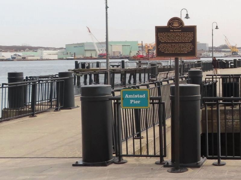
In the spring of 1761, the schooner Speedwell left the west coast of Africa with ninety-five captive Africans crowded beneath her deck. By the time it arrived in New London, Connecticut on July 17, only seventy-four were still alive. The . . . — — Map (db m216604) HM
On South Palafox Street at South Jefferson Street, on the left when traveling south on South Palafox Street.
Middle Passage to Pensacola
Beginning in the early 1500s and continuing for more than three
centuries, about 12 million enslaved Africans were transported
across the Atlantic Ocean from Africa to the Americas. This
transportation, known . . . — — Map (db m177047) HM
On Fort Mose Trail, 0.2 miles east of North Ponce De Leon Boulevard (U.S. 1), on the right when traveling north.
During the 18th century, thousands of enslaved Africans faced starvation, torture, and even death on their journey to the Americas, a voyage known as the middle passage.
What was the Middle Passage?
The Middle Leg of a 3-part Voyage:
. . . — — Map (db m126964) HM
Near San Marco Avenue (Business U.S. 1) at Old Mission Avenue (Business U.S. 1), on the right when traveling north.
Beginning in the early 1500s and continuing for more than three centuries, about 12 million African were transported across the Atlantic Ocean into slavery, in what has come to be known as the Middle Passage—the largest forced migration in . . . — — Map (db m80700) HM
On Meddin Drive north of Gulick Street, on the right when traveling north.
In 2019, Tybee Island was designated a UNESCO Site of Memory as a documented trans-Atlantic location where kidnapped African men, women, and children who survived the Middle Passage arrived. Fifty-three ports line the coast of the continental . . . — — Map (db m210670) HM
On Meddin Drive north of Gulick Street, on the right when traveling north.
The Middle Passage is a scar on the history of humanity. It is not a single race, religion or country's responsibility to bear; it belongs to the world. The enslavement of Africans was a global system that lasted more than 300 years. The Middle . . . — — Map (db m210667) HM
The Price of Prosperity
By the latter part of the 17th century, the development of the plantation economy of Maryland was well established. The shift of political power from English nobles to wealthy planters and fewer indentured servants . . . — — Map (db m146563) HM
Oxford is a documented Middle Passage port on Maryland’s Eastern Shore. As a major maritime tobacco sea port during the colonial period, there were four Transatlantic ships and twenty-five Intra-American voyages that delivered captive Africans to . . . — — Map (db m233434) HM
On Water Street south of State Street, on the right when traveling south.
Rhode Island was the center of the American transatlantic slave trade, accounting for the majority of American slave voyages from 1700 until 1808.
More than 110,000 Africans were forcibly taken from their homeland on Rhode Island ships and . . . — — Map (db m150887) HM
On Dr. Martin Luther King, Jr. Boulevard east of 7th Avenue North, on the right when traveling west.
Let this scarlet oak represent the strength and resilience of the people of African descent, and commemorate Africans who died in the Middle Passage, the leg of the Atlantic Triangle in which upwards of 100 million Africans were transported as . . . — — Map (db m131238) HM
On Harborside Drive at Moody Avenue, on the left when traveling east on Harborside Drive.
This marker commemorates enslaved Africans in Galveston during the late 18th and early 19th centuries, as well as those who perished during the transatlantic slave trade known as the Middle Passage.
Galveston Historical Foundation — — Map (db m147637) HM
On 4th Street north of Austin Avenue, on the right when traveling north.
Commemorating the lives of African Ancestors who perished during the Middle Passage and those who survived and were transported through Sabine Pass, Texas
1817 - 1837
Stony the road we trod,
Bitter the chastening rod,
Felt . . . — — Map (db m243677) HM
Near Gordon W Shelton Boulevard, 0.7 miles north of Willow Lane, on the left when traveling north.
Once passing through the portal of no return on the West African coast, slaves entered a world of unknown horrors. The Atlantic ocean represented a mystery to them because most Africans in the 17th and 18th centuries had not ventured out into . . . — — Map (db m176145) HM
Near Sophia Street, 0.2 miles south of Frederick Street, on the left when traveling south.
If the Atlantic were to dry up, it would reveal a scattered pathway of human bones, African bones marking the various routes of the Middle Passage.
-Dr. John Henrik Clarke (1915-1998)
From 1502 to 1860, the trans-Atlantic slave trade . . . — — Map (db m97364) HM
Near Colonial Parkway, 1.2 miles east of Jamestown Road (Virginia Route 31), on the right when traveling west.
The Middle Passage
For more than 350 years, approximately 12 million Africans were transported across the Atlantic Ocean in the largest forced migration in history. Two million, unknown and forgotten, died during the voyage. Of the ten . . . — — Map (db m147817) HM
The Middle Passage
For more than 350 years, approximately 12 million Africans were transported across the Atlantic Ocean in the largest forced human migration in history. Two million, unknown and forgotten, died during the voyage. Of the ten . . . — — Map (db m145947) HM
On Front Street at Orange Street, on the right when traveling east on Front Street.
Beaufort, North Carolina, was involved in the Trans-Atlantic human trade and is a documented Middle Passage arrival site.
Enslaved people disembarked at or neat this exact location, now called Topsail Park. Records from 1769 show that one . . . — — Map (db m226078) HM
The Middle Passage, part of a larger trade route known as the Triangular Trade, is the route which was used in the trafficking of captive Africans across the Atlantic Ocean to the Americas.
From the 16th to the 19th centuries, approximately 12 . . . — — Map (db m241337) HM
{Side 1}
The UNESCO Slave Route: Resistance, Liberty, Heritage
Launched in 1994, the international and inter-regional project ‘The Slave Route: Resistance, Liberty, Heritage’ addresses the history of the slave trade and slavery . . . — — Map (db m147638) HM
On San Fernando Street south of White Street, on the right when traveling south.
(side 1)
Launched in 1994, the international and inter-regional project ‘The Slave Route: Resistance, Liberty, Heritage’ addresses the history of the slave trade and slavery through the prism of intercultural dialogue, a culture of peace . . . — — Map (db m152489) HM
Honoring the Survivors of the Slave Ship Wanderer
The Wanderer survivors were among the last known groups of enslaved Africans smuggled into America. Their footsteps still echo along the Georgia coast and throughout America . . . — — Map (db m149405) HM
On Morgan Street west of Bermuda Street, on the left when traveling west.
The transatlantic slave trade to Louisiana began in 1718, with the first of two ships bringing African captives to the region in 1719. The first ship to arrive at this site was the Expedition, which landed 91 enslaved people, most from the . . . — — Map (db m157916) HM
Near Marcy Street east of Puddle Lane, on the right when traveling north.
People of African origin or descent have been part of Portsmouth since at least 1645.
This waterfront was an entry port for enslaved people arriving in New Hampshire during the 1600s and 1700s.
Ships brought black children and adults directly . . . — — Map (db m233865) HM
On North Front Street at Cooper Street, on the right when traveling north on North Front Street.
African slavery in New Jersey began with early European settlement. By 1766, circa 800 captive people had been sold here at Coopers Street Ferry and two other near ferry landings. In Africa, approximately 24 million men, women and children marched . . . — — Map (db m145252) HM
On South Water Street, on the right when traveling south.
The site of an 18th century seaport village where seafaring merchants participated in the African slave trade. In the 20th century this port was used by Cape Verdeans who came to live in America. — — Map (db m233864) HM
On Main Street at Court Street, on the right when traveling north on Main Street.
In memory of the millions of African people who perished during the middle passage, suffered the horrors of slavery, and endured the inhumanity of racial segregation. We also remember the heroes who have struggled and continue to work for freedom, . . . — — Map (db m62943) HM
On Federal Street (County Road 537) at Jersey Joe Walcott Boulevard, on the right when traveling west on Federal Street.
African slavery in New Jersey began with early European settlement. By 1766, circa 800 captive people had been sold here at the Federal Street Ferry and two other nearby ferry landings. In Africa, approximately 24 million captured men, women and . . . — — Map (db m208367) HM
Near Elm Street west of Jersey Joe Walcott Boulevard, on the left when traveling west.
African slavery in New Jersey began with early European settlement. By 1766, circa 800 captive people had been sold here at the Coopers Point Ferry and two other nearby ferry landings. In Africa, approximately 24 million captured men, women, and . . . — — Map (db m220914) HM
Near St. Peter Street east of Decatur Street, on the left when traveling east.
The trade of human beings from Africa to Louisiana began in 1718 with the first slave ships, the Aurore and the Duc du Maine, arriving in 1719. Those ships carried 451 enslaved Africans to the Louisiana colony. Their voyage marked the beginning . . . — — Map (db m117276) HM
The Memorial commemorates the arrival in Annapolis of Kunte Kinte, Alex Haley’s ancestor, as told in his book, Roots. That arrival was not a voluntary one. Kunte Kinte was one among one hundred-forty Africans forced into the hold of the slave . . . — — Map (db m6392) HM
Near Ocean Highway (U.S. 17) south of Grants Ferry Road (Georgia Route 99), on the left when traveling south.
Enslavement
Three hundred and fifty-seven enslaved Africans—men, women, and children—spent much or all of their lives in forced labor on this land that once belonged to James McGilvery Troup. Upon his death in 1849, these enslaved . . . — — Map (db m212673) HM
On High Street, 0.2 miles north of Cannon Street, on the left when traveling north.
In colonial times, Chestertown was designated the primary port of entry for the upper Eastern shore.
Bustling wharves lined the waterfront, where laborers loaded ships with local crops bound for Europe and the Caribbean. Vessels from . . . — — Map (db m138239) HM
On Front Street at Smith Street, on the right when traveling north on Front Street.
Near this site enslaved Africans disembarked at Perth Amboy, the principal port in eastern New Jersey. During colonial times, numerous slave ships such as the Catherine, William, Africa, and Sally were present in the Raritan Bay, sending their . . . — — Map (db m184553) HM
A place where...Africans were brought to this country under extreme conditions of human bondage and degradation. Tens of thousands of captives arrived on Sullivan's Island from the West African shores between 1700 and 1775. Those who remained in . . . — — Map (db m19123) HM
Near Gordon W Shelton Boulevard, 0.7 miles north of Willow Lane, on the right when traveling west.
Although most runaway slaves sought freedom individually, often resulting in leaving behind family members who may never be seen again, there are instances of bold and courageous efforts at emancipation that should be told. Clearly there was very . . . — — Map (db m176107) HM
On East Main Street (U.S. 60) at 15th Street, on the left when traveling east on East Main Street.
Liverpool, England • The Benin Region of West Africa • Richmond, Virginia
During the 18th Century, these three places reflected one of the well-known triangles in the trade of enslaved Africans.
Men, women and children were captured in . . . — — Map (db m20765) HM
On Harbor Drive, 0.3 miles north of Union Street, on the right when traveling north.
Launched in 1994, the International and inter-regional project ‘The Slave Route: Resistance, Liberty, Heritage’ addresses the history of the slave trade and slavery through the prism of intercultural dialogue, a culture of peace and . . . — — Map (db m233446) HM
Near Palmetto Avenue, 2.2 miles north of Fort George Road when traveling north.
English:
Once the Portuguese made successful transatlantic trading voyages, other European nations quickly followed. In the eighteenth century, the port of Nantes became the busiest French port involved in the European slave trade . . . — — Map (db m145391) HM
Near Gordon W Shelton Boulevard, 0.7 miles north of Willow Lane, on the left when traveling north.
The root meaning of the world hallelujah is an expression of joy, praise and gratitude. Certainly slaves in America upon securing their freedom were overcome with joy, praise, and gratitude. As such freedom became a celebration of perseverance, . . . — — Map (db m176136) HM
On Sophia Street, 0.1 miles south of Frederick Street, on the left when traveling south.
Virginia Fredericksburg
Augt 25th 1773
Messrs. Samuel &William Vernon
Gentlemen
You will by this opportunity be advised by Capt. Jno. Duncan of his Arrival here, & valuing himself on Col. John Thornton for his Services in disposal . . . — — Map (db m97371) HM
Near Brander Street, 0.5 miles east of Maury Street.
Spanning nearly 350 years, the Trans-Atlantic Slave Trade displaced over 12 million Africans from their native lands to foreign soils. European traders eager to fill the labor vacuum in the New World participated in the capture and sale of African . . . — — Map (db m41821) HM
On Grafton Road at Main Street (Vermont Route 121), on the left when traveling south on Grafton Road.
"... settled around on the floor …
when we all got calmed down
and on our stools ... Father would tell us stories of things that went on ...”
Daisy Turner, speaking of her father Alec
Alec Turner was a masterful . . . — — Map (db m179126) HM
On East Old Street at Rock Street, on the right when traveling east on East Old Street.
The Petersburg area has an extraordinarily rich African-American heritage. In 1625, most of the Africans in Virginia were servants at Flowerdew Hundred, nearby in Prince George County. In the 18th century, tens of thousands of newly enslaved . . . — — Map (db m57366) HM
On State Street (U.S. 1) east of Middle Street, on the right when traveling east.
(left panel)
I stand for the Ancestors Here and Beyond
I stand for those who feel anger
I stand for those who were treated unjustly
I stand for those who were taken from their loved ones
I stand for those who suffered . . . — — Map (db m115995) HM
* Inflectional forms of words are their plurals, singulars, and possessives as well as gramatical tenses and similar variations.