3000 BC - The first Amerindian people settle in the bay. Les premiers Amérindiens s'installent dans la baie. 1493 - One ship of Columbus fleet on his 2nd Voyage enters the bay and sees dwellings and people. Un navire de la flotte de Christophe . . . — — Map (db m94478) HM
This is the second national park established in Dominica and comprises both land and sea - rich in natural resources and historical features, the area supports a wide range of important activities, including diving, snorkeling, yachting, cruise . . . — — Map (db m94440) HM
Fort Shirley was positioned between the two hills with a direct line of site (sic, sight) to all parts of the garrison and guarding directly over Prince Rupert's Bay and the dock. The land side of the fort was protected by batteries in other . . . — — Map (db m94476) HM
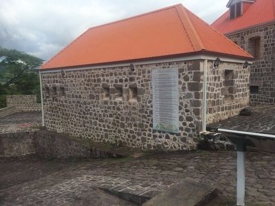
The Guard House, manned at all times, was the nerve centre of the entire garrison. All signals and comings and goings were monitored here. Gun slits faced onto the entrance passage in the event of an invasion. The room behind was the prison or . . . — — Map (db m94499) HM
The officers lived in separate quarters. Some had their families with them, in the married quarters on the slope or down in Roseau as the garrison, close to the swamp, was considered unhealthy. The Commandant live in an elegant house up against the . . . — — Map (db m94500) HM
The Cabrits headland was recognized by the British in the 18th century as a strategic site for a garrison to protect ships anchored in Price Rupert's Bay to collect fresh water and provisions, and for a defence stronghold between French colonies of . . . — — Map (db m94474) HM
During the 18th and early 19th centuries, most of the forest on the Cabrits was cut down to clear land for the garrison. The forest you now see around you dates from after 1854, when the garrison was abandoned. There are also some experimental . . . — — Map (db m94475) HM
The garrison at the Cabrits never saw any action, although the Battle of the Saints, fought between the French and British fleets on 12 April 1782, occurred within sight of the ramparts, and Fort Shirley was the scene of the revolt of the 8th West . . . — — Map (db m94501) HM
Fort Shirley was served by three cisterns that collected water from the roofs and the water catchment platform. If there was threat of an attack, water from the nearby rivers was brought into the fort by oxen cart. Food was purchased from . . . — — Map (db m94502) HM