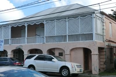
Two story, masonry, residence and shop, with 4 arcades on lower floor and gingerbread trim on second story balcony. Studio of photographer Alex Ovesen and birthplace of Evelyn Richardson. Owners include Samuel Wescott’s children 1864-1950, Wenona de . . . — — Map (db m60817) HM
Along the wharf you would have heard the creaking of rigging and pulleys as ships unloaded foodstuffs, plantation supplies, and building materials. The scent of sugar and molasses sweetened the air. Down the street plodded oxen, snorting with . . . — — Map (db m60815) HM
This building was the third stop in the local chain of commerce. After conducting business at the Scales and Guinea Company Warehouse, merchants and planters paid import and export taxes to Danish customs officials here in the ground-floor . . . — — Map (db m60709) HM
This fort played a vital role in Christiansted’s international trade. Built at harbor’s edge to protect commercial shipping from pirates and privateers, the fort embodied colonists’ fears as well as economic strength. Here were quartered Danish . . . — — Map (db m60707) HM
Since the dawn of consciousness, time has been measured by the movement of the sun. This marker, in the year 2000, is a continuum between all who have come before and all who are yet to come. The design concept starts with the Roman numeral “M”= . . . — — Map (db m60837) HM
This site marks the only point on the United States Territory where members of the crew of Christopher Columbus came ashore on his second voyage to the New World in November 1493. It also relates to the first recorded altercation between Europeans . . . — — Map (db m60782) HM
This building was the first Danish Lutheran church on the island—one of the few government buildings not directly involved in international trade. From 1754 to 1831 the Steeple Building was the embodiment of the Danish state religion. All . . . — — Map (db m60711) HM