Here rest the remains of
Silvester O'Dempsey Esq.
Who departed this life the 31 Dec. 1817
In the 70 year of his age
A Man
of the most steady Friendship
Unblemished Integrity extensive charity
And
Universal Benevolence
This frail . . . — — Map (db m26423) HM
Headfort Place was purposely widened and lined with trees in the 18th century to make it a suitable setting for its attractive Georgian houses. It is also here that a site for a parish church was donated to the Roman Catholic community by Lord . . . — — Map (db m27339) HM
The courthouse, built in 1801, was designed by the prominent Irish architect Francis Johnston. Johnston also designed the General Post Office and Nelson's Pillar in Dublin, and Townley Hall, County Louth.
A Vantage Point to the Past . . . — — Map (db m27340) HM
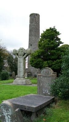
This tower is located on the grounds of St Columba's church and was built in the 10th century as part of the early Christian monastery. Such towers were referred to as a cloigteach meaning bell tower. Modelled on early Italian belfries, they were . . . — — Map (db m26440) HM
This 9th century high cross, the cross of the gate of the Kells monastery, is one of five high crosses still surviving in Kells. The cross of the gate, currently at or near its original site, was a termon cross and signified that a fugitive could . . . — — Map (db m27341) HM
Diarmuld MacCarroll, High King of Tara, is said to have granted the dun of Cenannus to St Columcille in the 6th century for the purpose of establishing a monastery. This may explain why in 804 the Columban community on the island of Iona . . . — — Map (db m26444) HM
Suffolk Street is an anglicisation of the ancient name Siofac, the meaning of which is today uncertain. The Annals of the Four Masters mentions a fire in 1156 burning the area of Kells from the cross of the gate to Siofoic. The name . . . — — Map (db m26424) HM
This wall marks the boundary of the original monastery and was rebuilt in 1714. When part of the wall collapsed after heavy rains in 1997, it was discovered to have no foundation. It was rebuilt again in 1998, this time with reinforced bulwarks. — — Map (db m26402) HM