Near Hache Gallant Drive, 1.2 kilometers east of Prince Edward Island Route 19, on the left when traveling east.
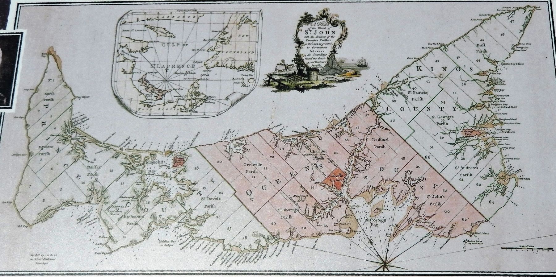
English: Working out of Fort Amherst between 1764 and 1765, Captain Samuel Holland, an engineer, directed a small team to produce an accurate survey of every inch of St. John's Island. It was the first phase of a major survey of . . . — — Map (db m151802) HM
Near Hache Gallant Drive, 1.2 kilometers east of Prince Edward Island Route 19, on the left when traveling east.
English: ”It is three years since the last refugee arrived on the island. They had to endure heavy losses and great hardship in getting here, and on arrival, they found themselves so to speak destitute… My Lord, unless you . . . — — Map (db m151801) HM
Near Hache Gallant Drive, 1.5 kilometers east of Prince Edward Island Route 19.
English: With Island history as your backdrop, you're looking out at Charlottetown Harbour, the Hillsborough River, Governors Island, and the bluffs of Keppoch. In the summertime, this waterway hosts an abundance of . . . — — Map (db m151792) HM
Near Hache Gallant Drive, 1.2 kilometers east of Prince Edward Island Route 19, on the left when traveling east.
English: Michel Haché-Gallant and Anne Cormier were the first Acadians to join the French colonists at Port-la-Joye. They arrived in 1720 from Beaubassin with four of their children. By 1730, eight Gallant children owned properties . . . — — Map (db m151797) HM
Near Hache Gallant Drive, 1.2 kilometers east of Prince Edward Island Route 19, on the left when traveling east.
Français:Première famille acadienne établie en permanence à L’Île-du-Prince-Édouard Ancêtres des familles Gallant et Haché du Canada et des États-Unis arrivés à Port-La-Joye en 1720 Monument érigé en 1965 par leurs . . . — — Map (db m151800) HM
Near Hache Gallant Drive, 1.2 kilometers east of Prince Edward Island Route 19, on the left when traveling east.
English: This timeline presents events that helped shape the history of Port-la-Joye—Fort Amherst, Prince Edward Island and Canada. Port-la-Joye was an imperial outpost for France for 38 years. For another ten years, Fort . . . — — Map (db m151804) HM
Near Hache Gallant Drive, 1.2 kilometers east of Prince Edward Island Route 19, on the left when traveling east.
English:We are in Port la Joye, one of the most beautiful harbours that the eye can behold. —Louis Denys de la Ronde, November 6, 1721 In 1720, three hundred men, women and children were brought from France to . . . — — Map (db m151803) HM
Near Haché Gallant Drive, 1.2 kilometers east of Prince Edward Island Route 19, on the left when traveling east.
English:
From 1720 to 1768 this site was an important colonial base, first for France and later Great Britain. One of the first permanent French settlements on the island, Port-la-Joye served as the seat of colonial government for . . . — — Map (db m139447) HM
On Prince Edward Island Route 19 just south of Rogers Passage Lane, on the left when traveling south.
English:
In 1764 the British government decided to undertake a systematic survey of its North American territory, recently enlarged in the war with France. For this purpose Captain Samuel Holland was put in charge of the northern . . . — — Map (db m139436) HM
Near Hache Gallant Drive, 1.2 kilometers east of Prince Edward Island Route 19, on the left when traveling east.
English: Lieutenant-Colonel Andrew Rollo arrived with a force of five hundred soldiers and took possession of Port-la-Joye on behalf of the British on August 17, 1758. The French governor at Louisbourg had given up both Île . . . — — Map (db m151799) HM
Near Haché Gallant Drive, 1.2 kilometers east of Prince Edward Island Route 19, on the left when traveling east.
English:
Undertaken here in 1758, this expulsion was one of the largest and the deadliest of the Acadian deportations that took place between 1755 and 1762. As part of a strategy to dismantle the French colony of Île Saint-Jean . . . — — Map (db m139446) HM
Near Hache Gallant Drive close to Blockhouse Road, on the left when traveling east.
English:
The Grand Dérangement
L’Acadie, established by France in 1604, was a strategically located and highly coveted colony. In 1713, it was handed over to England and renamed Nova Scotia. The foundation of Halifax, in 1749, . . . — — Map (db m80437) HM
Near Hache Gallant Drive, 1.2 kilometers east of Prince Edward Island Route 19, on the left when traveling east.
English: There has been an aboriginal presence on the Island for at least ten thousand years. The Mi’kmaq became allies and important trading partners with the French in the 1600s and later sided with them in battles against the . . . — — Map (db m151798) HM