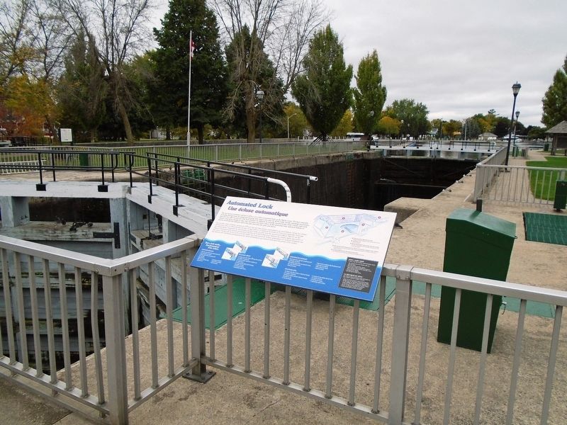
The new lock at Combined, opened in 1974, is one of three automated locks on the Rideau Canal. The basic principle of locking through boats by raising and lowering water levels is the same for all the locks, but the operating mechanisms that allow . . . — — Map (db m125629) HM
Created during the town's settlement in the early 1820's, the name of Beckwith Street and its bridge derived from Beckwith Township, when strong ties existed between the Anglican congregations of both communities. At 99 feet wide, Beckwith . . . — — Map (db m124644) HM
Opened in 1914, on the new Toronto-Ottawa line, this station reflected the western-based Canadian Northern's ambition to compete directly with the established Canadian Pacific Railway in populous Ontario in an attempt to achieve . . . — — Map (db m142128) HM
Construction of the Canadian Northern train station began in 1911 with an official opening in 1912. The building was intended to serve as a model of the railway's high architectural standards and to draw passenger traffic away from . . . — — Map (db m142120) HM
Canal, rail and highway converge at Smiths Falls, the crossroads of the Rideau corridor. Each means of transport, built in turn, changed the face of the town, the Rideau River, and this lockstation. Canal construction first transformed the . . . — — Map (db m125889) HM
Dedicated to All Veterans
And Peacekeepers of the Armed Forces
A Millenium Environmental Project
Initiated in the Year 2000 . . . — — Map (db m142077) HM
Launched in Kingston August 19, 1944 this Corvette (of the Flower Class) sailed under Pennant K345 commanded by Lt. CDR. Philip Taber Byers. The ship made 3 Atlantic crossings as a convoy escort, later transporting men to Quebec City who were . . . — — Map (db m124545) HM
This once marshy area was transformed into a picturesque space in 1897, as trees, flower gardens, and pathways were landscaped to create a "public pleasure ground". The area was named Victoria Park in honour of Queen Victoria's Diamond . . . — — Map (db m124791) HM
This stone, a reminder of the heritage of Smiths Falls,
was restored by the Smiths Falls Rotary Club
during the National Parks Centennial.
November 1985 . . . — — Map (db m124736) HM
The 3 locks here were designed to overcome a series of rapids with a total fall of over 7 metres (20 feet). A set like this is known as a flight of locks - each lock raises a vessel part of the way - rather like a stairway. Construction here . . . — — Map (db m124723) HM
Where are the Falls? The Town gets its name from a mile long series of rapids, which originally flowed from the water tower in Centennial Park, to the stone arch bridge on Beckwith Street. As boat traffic increased in the early . . . — — Map (db m142161) HM
The public Market Building was designed and constructed in 1892 by Matthew J. Ryan. Ryan was a local contractor who had also won contracts to build the Fire Hall, Town Hall, and St. Francis Catholic School. The interior of the market . . . — — Map (db m142168) HM
Constructed 1826-32 by the British government for military purposes, but used principally for commerce, the Rideau waterway, together with the lower Ottawa River, was the first canalized route from Montreal to the Great Lakes. Although eastbound . . . — — Map (db m142082) HM
The Rideau Waterway stretches 202 kilometres through a chain of lakes, rivers and canals, linking Smiths Falls, the heart of the Rideau, to the historic city of Kingston on Lake Ontario and to Ottawa, Canada's capital. To follow the Rideau . . . — — Map (db m142166) HM
The locks before you, replaced by the automated lock in 1974, are the only non-operational locks on the Rideau Canal. Their preservation reflects Parks Canada's commitment to protect and present canal heritage. These locks provide us with an . . . — — Map (db m125621) HM
Town Hall
The Town Hall was built in 1859 in the Classical Revival Style to house the municipal offices and council chambers of Smiths Falls including the Police and Fire Departments. In later years there were additions to the building such . . . — — Map (db m124512) HM
To the honoured
memory of those
who fought & fell
in the Great War
1914 — 1918
[Battles]
1915
Ypres·Festubert·Givenchy
1916
Somme·Sanctuary Wood·Courcelette
1917
Vimy Ridge·Hill 70·Lens·Passchendaele
1918 . . . — — Map (db m124565) HM
The current water system in Smiths Falls began in a three-story brick building in 1886 under the management of "Captain" Adam Foster. While it began on the east side of Beckwith Street to supply the water tanks in the CPR yards, it . . . — — Map (db m142155) HM
This lockstation is one link in the chain of rivers, lakes and waterway structures that make up the Rideau Canal. Built under the direction of the British military between 1826 and 1832 to serve as a supply route, the canal is an outstanding . . . — — Map (db m125638) HM
Originally built in 1830 under Abel Russell Ward, this site has changed faces and owners many times. Throughout the course of its history, it was an oatmeal and grist mill, and then rebuilt in 1887 under the new ownership of Alexander Wood. . . . — — Map (db m124632) HM
In Memory Of
Our Brave Dead
1914-1918.
S.W. Gilroy • G.B. Garton • G. Fields • A. Fields
J.B. Perkins • W.H. Cooke • F. Fumerton • S. Holland
J. McGill • C. Robinson • T. Powell • J. McShane
H. Polk • E. Megart • F.H. Prior • H. . . . — — Map (db m124501) WM