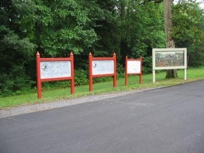
On Grant Drive at Brock Road (County Route 613), on the right when traveling north on Grant Drive.
May 8, 1864. Here began the second delay on Grant's bloody road to Richmond. Having failed to crush Lee in the Wilderness, the Federals attempted to outflank the Confederates by way of Spotsylvania Court House. After a hard night's march, harassed . . . — — Map (db m10199) HM
On Grant Drive at Brock Road (County Route 613), on the right when traveling north on Grant Drive.
May 9-14, 1864. The village of Spotsylvania Court House, two miles farther down the Brock Road, became of utmost temporary importance, since it now protected Lee's communications with Richmond. As the Confederates threw up earthworks around the . . . — — Map (db m10205) HM
On Hancock Road, 0.1 miles south of Brock Road (County Route 613), on the left when traveling south.
Union Gen. G.K. Warren's V Corps occupied this line in the early phases of the Spotsylvania operations. Despite hard fighting, Warren could not break the Confederate line on this front. During the dark and rainy night of May 13, 1864, the V Corps . . . — — Map (db m10213) HM
On Grant Drive, on the right when traveling north.
May 10,1864. After a day of sporadic fighting, the Federal high command sent Col. Emory Upton and twelve picked regiments of the VI Corps to strike the west face of the Confederate Salient. Starting in this vicinity near the Scott (Shelton) House . . . — — Map (db m10302) HM
On Anderson Drive, on the right when traveling south.
May 10, 1864. Here along the west face of the Confederate Salient, or "Mule Shoe," Dole's Brigade of Ewell's II Corps had been alert all afternoon. At 6 p.m., when Federal cannonading ceased, it seemed the day would end quietly. Then Upton's . . . — — Map (db m10295) HM
This road leads to the Landram House ruin. In the days of the Civil War it was a small whitewashed dwelling built of squared logs and heated by stone-chimneyed fireplaces. From similar modest homesteads, North and South, had spring Abraham Lincoln . . . — — Map (db m10309) HM
Near Grant Drive, on the left when traveling east.
May 12, 1864. Union commanders Grant and Meade determined to exploit the Confederate "Mule Shoe." Early in the morning they sent Hancock's II Corps against the apex of the Salient (300 yards east). Hancock took the trenches on either side of the . . . — — Map (db m10310) HM
Near Grant Drive, on the left when traveling east.
May 12, 1864. About 6 a.m. Wright's VI Corps advancing to support Hancock's attack occupied the area in front of the Confederate works on the west face of the Salient. Here at a slight bend in the line, the area ever after known as the Bloody Angle, . . . — — Map (db m10311) HM
On Anderson Drive, on the right when traveling south.
May 12-13, 1864. This line of earthworks, the remains of which run eastward through the woodland, was built across the base of the Confederate "Mule Shoe" during the Federal attacks against the Salient. As the weary Confederates held their enemies . . . — — Map (db m10278) HM
On Anderson Drive, on the right when traveling south.
May 18, 1864. About dawn, Hancock's and Wright's Corps advanced southward past the McCoull House and attacked Ewell's Corps which was holding the new line. They hoped to repeat the Federal success of May 12. This time, however, Confederate cannon . . . — — Map (db m10279) HM
On Gordon Drive, on the right when traveling east.
May 12, 1864. From this point the trenches of the Confederate Salient run southward. This road continues westward along a secondary line which was held by Gordon's Division. Gordon's line tied into the east face of the Salient here, where Ewell's . . . — — Map (db m10427) HM
Near Gordon Drive, on the left when traveling north.
May 12, 1864. About 4:30 a.m. Hancock's Federal II Corps, in one of the greatest surprise attacks of the War, struck Ewell's Confederate Corps entrenched here. Advancing in a solid rectangular mass, the Federal troops overwhelmed the defenders. The . . . — — Map (db m10397) HM
Near Gordon Drive, on the left when traveling north.
May 12, 1864. In the large scale attack of this day, Warren's V Corps on the Federal right and Burnside's IX on the left engaged the Confederate forces facing them while Wright's VI moved to help Hancock. The seriousness of Lee's counterattack . . . — — Map (db m10403) HM
On Burnside Drive, on the right when traveling east.
May 12, 1864. Burnside's IX Corps, having swung east in its march from the Wilderness, engaged the Confederates by way of the Fredericksburg-Spotsylvania Road and held the Federal left in this area. On the morning of May 12 Burnside was ordered to . . . — — Map (db m10429) HM