South Inscription:
The Congress of the United States has caused this Monument to be erected on the site of the Battle of Cowpens as a testimonial to the valor and in appreciation of the services of the American Troops on this field in . . . — — Map (db m11186) HM
"Sir-you are appointed to the command of a corps of Light Infantry, a detachment of Militia, and Lt. Col. Washington's Regiment of Light Dragoons...The object of this detachment is to give protection to that part of the country and spirit up . . . — — Map (db m13061) HM
The British soldiers arrived at the Cow Pens about dawn. The right flank of the British army formed in this general area with the rest of the troops stretching across the Green River Road. Ahead, in the distance, Morgan's army awaited. — — Map (db m11356) HM
British commander, Lt. Col. Banastre Tarleton, ordered a detachment of cavalry forward to scatter the American skirmishers. The green-uniformed British Legion - Americans loyal to the king - awaited the order to advance. — — Map (db m11357) HM
Morgan's army came from many states-the two Carolinas, Delaware, Georgia, Maryland, and Virginia. They were joined by the militia, some of whom had helped destroy the British army of loyalist Americans under Ferguson at Kings Mountain. They . . . — — Map (db m13035) HM
The view seen beyond was a frontier pasturing ground, known locally as the Cow Pens. The name came from the custom of wintering cattle in the lush area around Thicketty Mountain.
General Daniel Morgan chose this ground for its tactical . . . — — Map (db m126716) HM
The sharpshooters at the skirmish line waited until Tarleton's army got within shooting distance. Their orders were to slow Tarleton's advance with well-aimed rifle fire and then fall back to the militia second line. As the British came within . . . — — Map (db m13065) HM
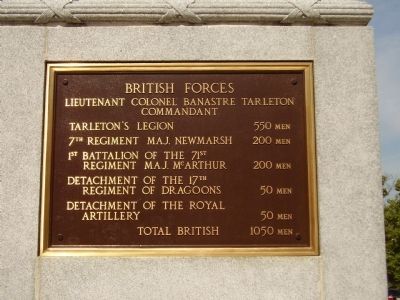
Today Tarleton's force would be called a combined arms task force. It contained all the elements to conduct a quick movement and "engage an enemy." Ranks of redcoated fusiliers, regulars, and raw recruits of the 7th Regiment formed in this immediate . . . — — Map (db m13423) HM
The American second line of defense stood in position here. About sunrise,the British appeared. The militia, though not trained to stand against massed British bayonets, fought well and shot with deadly effect. "At first it was pop, pop, pop . . . — — Map (db m77693) HM
After firing as ordered, the American skirmishers melted back to the second line of defense.
Seeing this, the British troops moved forward at quickstep, raising a great shout as they advanced. — — Map (db m13028) HM
This line consisted of Continentals from Maryland and Delaware as well as militia from Virginia and North Carolina. Seasoned veterans under Lt. Col. John Eager Howard of Maryland, they had served at least one year and were Morgan's most reliable . . . — — Map (db m13064) HM
This Monument was erected by
The Washington Light Infantry
Of Charleston S.C.
L.M. Hatch. Capt
April. 1856
Cowpens Chapter D.A.R.
1936 — — Map (db m13385) HM
On this field, the Continentals blunted the British advance, then charged with bayonets flashing. Cavalry hit the left and right of the 71st. The militia reformed and surged against the right and left. British troops found themselves overwhelmed . . . — — Map (db m13030) HM
After firing twice, the militia retreated behind the
Continentals who were awaiting the British advance in this area. British reinforcements, Fraser's 71st Highlanders, threatened the Continentals' right flank. Lt. Col. Howard ordered his right . . . — — Map (db m13031) HM
Near the end of the battle, as the Americans swept forward, two Continental officers sought to capture the enemy's light 3-pounder "grasshopper" cannons. Captain Anderson of Maryland won the race when he used his spontoon to vault forward onto one . . . — — Map (db m13029) HM
The open forests proved well-suited for cavalry action. Fast-moving, hard-hitting mounted troops called Light Dragoons bolstered the 18th century infantry.
At least seventy South Carolina and Georgia mounted militiamen, armed with pistols and . . . — — Map (db m13063) HM
Nearby, retreating British officers of the 17th Light Dragoons, clashed with pursuing American horsemen led by Lt. Col. William Washington. He quickly outpaced his troops, broke his weapon at the hilt when he got into a sword fight with a British . . . — — Map (db m13025) HM
Robert Scruggs married Catherine Connell, and in 1828 his father, Richard Scruggs, gave them 200 acres of land. They had eleven children and added onto the house as the family grew.
Life at the time was hard; yeomen farmers raised corn, . . . — — Map (db m126717) HM
General Morgan's army secured a great victory on the field before you: "Our loss was inconsiderable, not having more than twelve killed and sixty wounded. The enemy's loss was 10 commissioned officers and over 100 rank and file killed and 200 . . . — — Map (db m13034) HM
The Overmountain Victory National Historic Trail preserves and commemorates the route of Patriot militia during the 1780 Kings Mountain campaign.
During that historic event, on October 6, 1780, American forces stopped here at the Cow Pens to rest . . . — — Map (db m108660) HM
After victory at Cowpens, American commander, General Daniel Morgan marches his army off this field to the north and crossed the Broad River. In North Carolina, Morgan dismissed the militia.
Many of the heroes of Cowpens helped build the . . . — — Map (db m34739) HM