5 entries match your criteria.
Related Historical Markers
By Syd Whittle, September 8, 2008
Old Coloma Road Marker
SHOWN IN SOURCE-SPECIFIED ORDER
| | With the discovery of gold on January 24, 1848, Coloma Road became one of the primary routes to the gold fields of El Dorado County. The road started at Sutter’s Fort (New Helvitia), then proceeded to Willow Springs (near Folsom), Mormon Island, . . . — — Map (db m11282) HM |
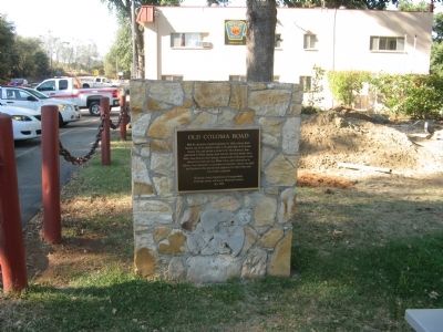
| | Past this point on the Old Coloma Road, running between Sutter’s Fort and his sawmill on the American River, James W. Marshall rode with the first gold discovered at Coloma on Jan. 24, 1848. Traveled by thousands to and from the diggings, this road . . . — — Map (db m11268) HM |
| | This rock monument marks site of John A. Sutter's saw mill in the tailrace of which James W. Marshall discovered gold, January 24, 1848, starting the great rush of argonauts to California. The Society of California Pioneers definitely located and . . . — — Map (db m39015) HM |
| | Alder Springs, south of this point, marks the Old Coloma Road, running between Sutter’s Fort and Culluh-mah (Coloma). Established in 1847, this road was used by James W. Marshall in January 1848 to bring the first gold from Sutter’s Mill to the . . . — — Map (db m11901) HM |
| | Sutter’s Fort, established by Capt. John A. Sutter in August 1839, marked the Western end of the Coloma Road. Opened in 1847, this road ran from the Fort to Sutter’s sawmill at Coloma. Used by James W. Marshall in January 1848 to bring the news of . . . — — Map (db m11897) HM |
Apr. 23, 2024