4 entries match your criteria.
Related Historical Markers
Markers relating to the Beefsteak Raid.
By Bill Coughlin, April 25, 2006
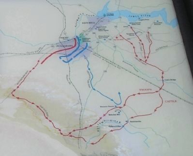
The Beefsteak Raid Map from the Marker
SHOWN IN SOURCE-SPECIFIED ORDER
| | As the summer of 1864 ended with Union Gen. U.S. Grant’s army still laying siege to Petersburg, Southern sources learned of a large herd of cattle being held at nearby Coggin’s Point on the James River. The cattle were grazing at “Beechwood,” the . . . — — Map (db m14773) HM |
| | Leaving from a point along the Confederate right flank on Boydon Plank Road on 14 Sept. 1864, Maj. Gen. Wade Hampton took about 3,000 Confederate cavalrymen and rode more than 100 miles around the rear of the Union army. Reaching Coggins’ Point on . . . — — Map (db m14775) HM |
| | One mile southwest, on September 16, 1864, General Wade Hampton's Confederate Cavalry herded about 2500 head of captured cattle across the Nottoway River, while two miles northwest, at Belsches' Mill, Federal troops sent to recapture the cattle were . . . — — Map (db m18156) HM |
| | Just to the north of the road here, at old Sycamore Church, Wade Hampton, coming from the south, attacked the Union cavalry guarding Grant's beef cattle, September 16, 1864. The Unionists were overpowered; Hampton, rounding up 2,500 beeves, . . . — — Map (db m17734) HM |
Apr. 25, 2024