On Central Avenue (New Hampshire Route 9) at Third Street, on the right when traveling south on Central Avenue.
The American House Hotel opened ca. 1865 by William B. Smith in what was originally a private residence. After Smith’s death, his wife operated it through 1867 until selling to Col. Adams T. Peirce and L.P. True. By 1878, Peirce and True, . . . — — Map (db m152221) HM
On Central Avenue (New Hampshire Route 9) south of First Street, on the right when traveling south.
Dover’s early settlers lived in relative peace with the local Pennacook tribe, learning hunting, fishing, and farming skills from the natives in the early 17th century. Passaconaway, highly respected leader of the Pennacook Confederacy, forged . . . — — Map (db m152213) HM
On Central Avenue (New Hampshire Route 9) at Waldron Court, on the right when traveling south on Central Avenue.
These early 19th century storefronts have always been at the heart of Dover's downtown business district. In this ca. 1950 photo (left), is Sweetlands, John N. Vatistas proprietor, which opened in the mid-1940s. By the '70s, still in the . . . — — Map (db m152212) HM
On Central Avenue (New Hampshire Route 9) at Washington Street (New Hampshire Route 108), on the right when traveling south on Central Avenue.
Central (Lower) Square, just after the turn of the 20th century, shows the bustling business activity at the intersection of Central Avenue and Washington Street. On the right is the Masonic Temple housing, among many other businesses, Frank J. . . . — — Map (db m152208) HM
On Chapel Street (New Hampshire Route 4) just east of Saint John Street (New Hampshire Route 4), on the left when traveling east.
St. John's Methodist Church, now St. John's Senior Housing, was built in 1875 for $40,000. Methodism is the third oldest religious denomination in Dover (after the Congregationalists and the Quakers) and their worship services began in 1819 at . . . — — Map (db m152217) HM
On Central Avenue (New Hampshire Route 9) south of First Street, on the right when traveling south.
Dover's Black Day began with a record breaking rainfall March 1 & 2, 1896 which ravaged downtown Dover. The Central Avenue bridge was swept away by torrents of rushing water and ice floes; several stores and offices in the Bracewell Building . . . — — Map (db m217308) HM
Near Central Avenue (New Hampshire Route 9) at First Street, on the left when traveling south.
After ousting the mills' benevolent founder John Williams, the Cocheco Manufacturing Company's new Boston owners put a different agent in charge. James Curtis was a harsh taskmaster, caring only about profit and having little concern for the . . . — — Map (db m152215) HM
On Main Street (New Hampshire Route 9) at Chapel Street (New Hampshire Route 4), on the right when traveling north on Main Street.
The two Morrill blocks, constructed by Joseph Morrill in 1844 and 1870, dominate the landscape of Franklin Square in 1921. The smaller block, on the left bordering Second Street, is the earlier structure. Businesses in these blocks included . . . — — Map (db m152216) HM
On Main Street (New Hampshire Route 9) north of Chapel Street (New Hampshire Route 4), on the right when traveling north.
Dover’s two largest retail chain stores can be seen on opposite sides of Central Avenue: Montgomery Ward, on the left, faced J.J. Newberry's on the corner of Second Street. The “new” Morrill Block, rebuilt after a devastating fire in . . . — — Map (db m152218) HM
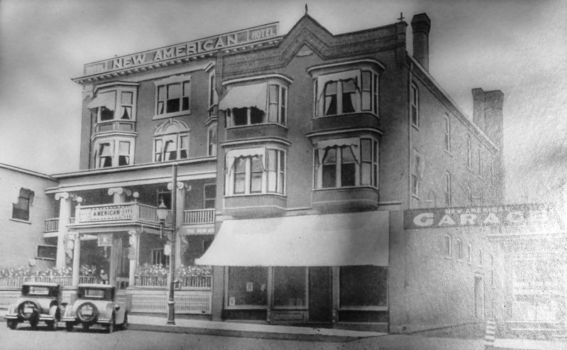
On Main Street (New Hampshire Route 9) at Third Street, on the right when traveling north on Main Street.
The New Depot on Third Street, after the arrival of the B&M railroad to Dover in 1842, attracted a variety of businesses including hotels, saloons, pool halls, restaurants, and stores catering to travelers' needs. This photo, from the 1920s, . . . — — Map (db m152219) HM
Near Central Avenue (New Hampshire Route 9) at Third Street, on the left when traveling south.
Merchants National Bank began operations on April 2, 1900 with $100,000 in capital, founded by Charles Carpenter Goss of Pittsfield. Mr. Goss was the first cashier and his grandfather Charles H. Carpenter was chosen as the first president. . . . — — Map (db m152220) HM
On Central Avenue (New Hampshire Route 9) at Washington Street (New Hampshire Route 108), on the right when traveling north on Central Avenue.
This photo of Central Square (now called Lower Square), at the intersection of Central Avenue and Washington Street, was taken between 1895 and 1906. Dominating the right side is the Strafford Bank building, erected for $100,000 in 1895. The . . . — — Map (db m152211) HM
On Hale Street west of Central Avenue (New Hampshire Route 9), on the right when traveling west.
Dover’s City Hall and Opera House burned at this location on August 3, 1933. The first two city halls, located at the corner of Washington Street and Central Avenue (where the Masonic Temple now stands) had also burned, respectively, in 1866 . . . — — Map (db m152210) HM