3 entries match your criteria.
Related Historical Markers
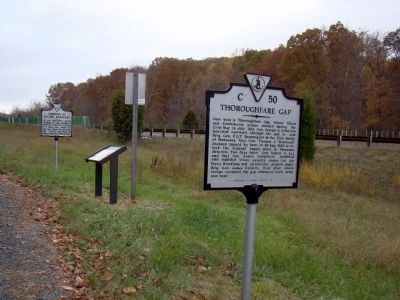
Thoroughfare Gap Markers
By J. J. Prats, October 31, 2009
Thoroughfare Gap and Two Other Markers
SHOWN IN SOURCE-SPECIFIED ORDER
| | Just west is Thoroughfare Gap where Union and Confederate armies clashed during the Civil War. In July 1861, Gen. Joseph E. Johnston marched eastward through the gap to join Brig. Gen. P.G.T. Beauregard in the First Battle of Manassas. Maj. Gen. . . . — — Map (db m167410) HM |
| | The gap to your left between Biscuit Mountain (the northern promontory of Pond Mountain) on the south and Mother Leathercoat Mountain on the north, described as “that dark, gloomy cleft” in an 1862 issue of Frank Leslie’s Illustrated . . . — — Map (db m167749) HM |
| | Lee and Longstreet, moving eastward to join Jackson at Manassas, found this gap held by a Union force, August 28, 1862. They forced the gap, after some fighting, and moved on toward Manassas, August 29, 1862. — — Map (db m607) HM |
Apr. 17, 2024