Near Luray in Page County, Virginia — The American South (Mid-Atlantic)
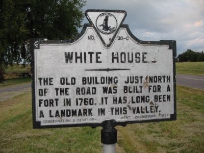
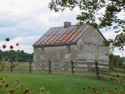
White House
Erected 1927 by Conservation and Development Commission. (Marker Number C-30.)
Topics and series. This historical marker is listed in these topic lists: Forts and Castles • Notable Buildings • Settlements & Settlers • War, US Civil. In addition, it is included in the Virginia Department of Historic Resources (DHR) series list. A significant historical year for this entry is 1760.
Location. This marker has been replaced by another marker nearby. It was located near 38° 38.852′ N, 78° 31.873′ W. Marker was near Luray, Virginia, in Page County. Marker was on Lee Highway (U.S. 211) west of the U.S. Route 340 South turnoff, on the right when traveling west. Touch for map. Marker was at or near this postal address: 150 US-340, Luray VA 22835, United States of America. Touch for directions.
Other nearby markers. At least 8 other markers are within 3 miles of this location, measured as the crow flies. A different marker also named White House (a few steps from this marker); Historic White House 1760 (a few steps from this marker); White House Bridge (a few steps from this marker); The Reverend John Roads (Rhodes) (a few steps from this marker); Massanutton (approx. 0.6 miles away); Calendine (approx. 1.2 miles away); Mauck Meeting House (approx. 1.2 miles away); Luray Caverns (approx. 2.8 miles away). Touch for a list and map of all markers in Luray.
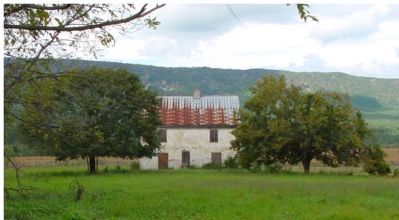
More about this marker. This marker was closer to the White House and the river when it was first erected; the house is now west of the marker, and at a distance. It was probably moved here when the road was widened or when the new highway bridge was built.
Regarding White House. Home and meeting house of pioneer Martin Kauffman II, minister to a small Mennonite congregation. A ferry, the White House Ferry, and the White House Bridge across the South Fork of the Shenandoah River took their name from this house. The house and bridge played a critical role during the Civil War during the Valley Campaign of 1862. Confederates burned the bridge on June 2nd, just an hour before the arrival of Union forces attempting to overtake Stonewall Jackson's army, allowing Jackson to engage and defeat General Fremont and then General Shields at Cross Keys, and Port Republic June 8th and 9th.
Built

Photographed By J. J. Prats, September 29, 2006
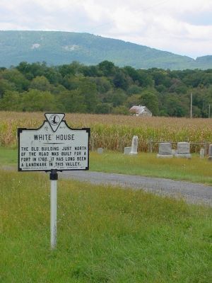
2. Marker With White House In the Distance
Massanutten, the 50 mile long mountain that rises in the center of the Shenandoah Valley, can be seen in the distance. U.S. 211 crosses it at Thornton Gap, out of frame to the left. Moreland Gap is visible on the right.
This marker is one of several detailing Civil War activities in Page County, Virginia. Please see the Page County Civil War Markers link below.
Related marker. Click here for another marker that is related to this marker. The linked marker has replaced this marker.
Also see . . . Page County Civil War Markers. (Submitted on February 25, 2009, by Craig Swain of Leesburg, Virginia.)
Additional commentary.
1. Indian attacks
Did the "White House" ever come under attack from indians? I'm asking because, in 1992 my father , Robert Presgraves, now deceased, found an indian war axe while fishing in the river almost directly across the road from the house. My understanding is that the raiding parties would stop some distance away from the attack sites, chip out these rough axes, then toss them away when leaving. I've put the axe up around here somewhere but would appreciate any information.
Editor's Note: While I can find no direct information about attacks on this particular property, it was very likely. Given the year it was built, its designation as a fort, and the events of the Massanutten area during that era, it's hard to believe it would have been ignored. For more information see the nearby marker titled, "The Reverend John Roads (Rhodes)," which is within shouting distance of this marker.
— Submitted September 1, 2009, by Richard S. Presgraves of Amissville, Virgini.
Credits. This page was last revised on January 24, 2024. It was originally submitted on October 2, 2006, by J. J. Prats of Powell, Ohio. This page has been viewed 4,467 times since then and 109 times this year. Last updated on January 24, 2024, by Carl Gordon Moore Jr. of North East, Maryland. Photos: 1. submitted on October 13, 2008, by Craig Swain of Leesburg, Virginia. 2, 3, 4. submitted on October 2, 2006, by J. J. Prats of Powell, Ohio. • J. Makali Bruton was the editor who published this page.


