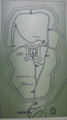
Fort Mill Ridge is a Union fortification constructed between March and June, 1863, to defend the Mechanicsburg Gap and South Branch Potomac Valley. The remains of the fortification have been undisturbed over the past 135 years and are among the most . . . — — Map (db m167998) HM
At the time of the Civil War, the South Branch Valley was comprised of many small, independent farms. The mid-19th century was a golden age of agriculture in the eastern United States, and the valley was among the most agriculturally productive . . . — — Map (db m25186) HM
On March 16, 1863, Col. Campbell ordered his command to move their encampment from Romney to the fields adjacent to Mill Creek immediately west of Mill Ridge. Sheltered between the mountain to the west and the ridge, the camp was less vulnerable to . . . — — Map (db m25203) HM
The central redoubt house the fort's artillery. The square structure is approximately forty feet wide inside. The fort's entrance was located on the north, its least vulnerable side. Two artillery positions were constructed on each of the other . . . — — Map (db m25244) HM
The central redoubt consists of a square earthen platform or rampart, and earthen walls, or parapets. Cuts in the parapets, or embrasures, provided openings through which cannons could fire. The remains of the embrasures can be . . . — — Map (db m25300) HM
Federal Battery E, 1st (West) Virginia Volunteer Artillery was assigned to the command at Fort Mill Ridge. The Battery was armed with six 3-inch rifled cannons. It is believed that two of these cannons were positioned in the central redoubt. The . . . — — Map (db m25315) HM
Around the outside of the central redoubt is the ditch, a significant obstacle attackers would have to climb through to assault the redoubt. At Fort Mill Ridge, the ditch also appears to have been used as a trench from which defending . . . — — Map (db m203672) HM
From the protection of the fort and their encampment along Mill Creek, Union soldiers were stationed at picket posts throughout adjacent valleys at key junctions, fords, and approaches. Patrols were sent through the country-side to feel for the . . . — — Map (db m25433) HM
In early April, 1863, a Confederate force led by Captain John H. McNeill's Rangers and four additional companies of Virginia cavalry left Rockingham County for West Virginia. At Moorefield, 20 miles south of Fort Mill Ridge, the force divided into . . . — — Map (db m25353) HM
In late April 1863, the Confederates launched a major raid from Rockingham County into West Virginia. A primary goal of the raid was the destruction of the Cheat River Bridge of the B&O Railroad near the Northwestern Turnpike crossing the Cheat . . . — — Map (db m25436) HM
The Union troops at Fort Mill Ridge continued their duties until June 14, 1863. Then, in response to Lee's invasion of Pennsylvania, Campbell's command was ordered to concentrate with the rest of their division at New Creek (Keyser). Confederate . . . — — Map (db m25438) HM