Sutherland in Dinwiddie County, Virginia — The American South (Mid-Atlantic)
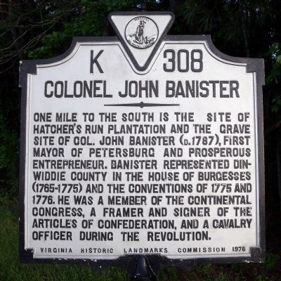
Colonel John Banister
Erected 1976 by Virginia Historic Landmarks Commission. (Marker Number K-308.)
Topics and series. This historical marker is listed in these topic lists: Agriculture • Colonial Era • Patriots & Patriotism • Settlements & Settlers • War, US Revolutionary. In addition, it is included in the Virginia Department of Historic Resources (DHR) series list. A significant historical year for this entry is 1775.
Location. This marker has been replaced by another marker nearby. It was located near 37° 11.7′ N, 77° 35.183′ W. Marker was in Sutherland, Virginia, in Dinwiddie County. Marker was on Cox Road (U.S. 460) 0.8 miles east of Tranquility Lane, on the right when traveling east. Touch for map. Marker was in this post office area: Sutherland VA 23885, United States of America. Touch for directions.
Other nearby markers. At least 8 other markers are within 2 miles of this location, measured as the crow flies. Col. John Banister (here, next to this marker); Rocky Branch School (approx. 0.8 miles away); The Battle of Sutherland (approx. 1.2 miles away); Sutherland Station (approx. 1.2 miles away); a different marker also named Sutherland Station (approx. 1.2 miles away); Fork Inn (approx. 1.2 miles away); Engagement at Sutherland Station (approx. 1.3 miles away); Appomattox Campaign (Sutherland Station) (approx. 1.3 miles away). Touch for a list and map of all markers in Sutherland.
Related marker. Click here for another marker that is related to this marker. New Marker At This Location titled "Col. John Banister".
Credits. This page was last revised on November 5, 2021. It was originally submitted on May 15, 2009, by Bernard Fisher of Richmond, Virginia. This page has been viewed 1,244 times since then and 32 times this year. Photos: 1, 2. submitted on May 15, 2009, by Bernard Fisher of Richmond, Virginia.

