Parkersburg in Wood County, West Virginia — The American South (Appalachia)
Fort Boreman Hill
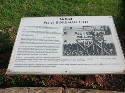
The same natural feature, panoramic views, and a commanding position above the Ohio and Little Kanawha rivers that enticed the military to position themselves here during the war also had encouraged early Indians to set up camps on the hill.
Approximately one-half mile to the east, on a ridge overlooking South Parkersburg, was the site of the “Pest House.” The City of Parkersburg constructed it in 1867 as a place to quarantine victims of smallpox and other contagious diseases. Locally, the two-story house became known as the “house of doom”; many of the patients died and were buried in the pest house cemetery.
To the left of the entry road, just before reaching the park entrance is the site of the infamous hangings of 1867. The men, Daniel Grogan, Thomas Boice, and Mortimer Gibbony, were convicted for the murder of Abram Deem, a well-respected Wood County farmer who was a Confederate sympathizer. Though local lore credits a notorious “hanging tree” as the gallows, the men were actually hanged from a scaffold.
In 1893, on a knoll on the western side of Fort Boreman Hill, Gustavus Fries built a public park consisting of ten-pin bowling lanes, a dance hall, concession stand, and picnic areas. In addition to a shaded place to relax and enjoy a natural setting, Fries Park offered a venue for musical concerts and even hosted prize fights. The park remained active into the 1940s.
Fort Boreman Hill has been the site of diverse uses for thousands of years; strategic defense, amusement, medical quarantine, and public hangings, and now, in continuance of its public service, as a place to memorialize and remember the past.
Topics. This historical marker is listed in these topic lists: Forts and Castles • Settlements & Settlers • War, US Civil. A significant historical year for this entry is 1867.
Location. This marker has been replaced by another marker nearby. It was located near 39° 15.724′ N, 81° 34.156′ W. Marker was in Parkersburg, West Virginia, in Wood County. Marker was on Fort Boreman Drive, one mile south of Robert Byrd Highway (U.S. 50). The marker is located in Fort Boreman Park. Touch for map. Marker was in this post office area: Parkersburg WV 26101, United States of America. Touch for directions.
Other nearby markers. At least 8 other markers are within walking distance of this location. Parkersburg in 1861 (here, next to this marker); Welcome (a few steps from this marker); Fort Boreman During The Civil War (a few steps from this marker); Fort Boreman (within shouting distance of this marker); William L. “Mudwall” Jackson (within shouting distance of this marker); a different marker also named Fort Boreman Hill (within shouting distance of this marker); a different marker also named Fort Boreman (within shouting distance of this marker); Historic Parkersburg (West) Virginia (within shouting distance of this marker). Touch for a list and map of all markers in Parkersburg.
Related marker. Click here for another marker that is related to this marker. New Marker At This Location also titled "Fort Boreman Hill".
Credits. This page was last revised on January 8, 2022. It was originally submitted on May 11, 2014, by Don Morfe of Baltimore, Maryland. This page has been viewed 620 times since then and 49 times this year. Photos: 1, 2, 3. submitted on May 11, 2014, by Don Morfe of Baltimore, Maryland. • Bernard Fisher was the editor who published this page.


