7 entries match your criteria.
Related Historical Markers
To better understand the relationship, study each marker in the order shown.
By Craig Swain, April 6, 2007
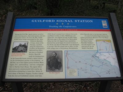
Guilford Signal Station Marker
SHOWN IN SOURCE-SPECIFIED ORDER
| Near Old Vestal's Gap Road. |
| | During the Civil War, signal stations served as early warning posts, observation points, and communication centers. On June 19, 1863, 10,000—15,000 Union troops commanded by Gen. John Fullerton Reynolds, I Corps, Army of the Potomac, marched along . . . — — Map (db m203825) HM |
| On Loudoun Street SW, on the right when traveling west. |
| | “Leesburg! Paradise of the youthful warrior! Land of excellent edibles and beautiful maidens!” — so wrote a Confederate artilleryman in late 1861. A year later, a northern correspondent found Leesburg a weary town full of . . . — — Map (db m1544) HM |
| On Catoctin Mountain Highway (U.S. 15) at Willow Road, on the right when traveling north on Catoctin Mountain Highway. |
| | It was here that George Armstrong Custer was first introduced as a general to the troops he would command. The first order signed by Gen. George G. Meade as the newly appointed commander of the Army of the Potomac on June 28, 1863 promoted three . . . — — Map (db m1539) HM |
| On Hessong Bridge Road, on the left when traveling north. |
| | When the Confederate Army of Northern Virginia Invaded Maryland in June 1863, the Army of the Potomac headed north in pursuit. On Monday, June 29, a “rainy, miserable day,” the 15,000 men, 2,900 horses and mules and 475 wagons of Gen. John F. . . . — — Map (db m105250) HM |
| On Blacks Mill Road at Catoctin Furnace Road (Maryland Route 806) on Blacks Mill Road. |
| | When Union Gen. John F. Reynolds’ I Corps marched by here on June 29, 1863, en route to Emmitsburg and soon to Gettysburg, his men were progressing “swimmingly.” The workers of the Catoctin Furnace had little time to notice, since the charcoal . . . — — Map (db m105249) HM |
| On Main Street (Maryland Route 77) at Water Street / North Church Street, on the right when traveling west on Main Street. |
| | On June 29, 1863, Mechanicstown was full of the noise of an army on the move as Union Gen. John F. Reynolds marched I Corps to Emmitsburg. Until then, residents had only heard rumors of the advancing Confederates as nervous farmers hurried horses . . . — — Map (db m203039) HM |
| Near Catoctin Mountain Highway (U.S. 15), on the right. Reported permanently removed. |
| | President Abraham Lincoln replaced Army of the Potomac commander Gen. Joseph Hooker with Gen. George G. Meade on June 28, 1863, as the army pursued Gen. Robert E. Lee’s Army of Northern Virginia. Meade placed Gen. John F. Reynolds, I Corps . . . — — Map (db m1546) HM |
Apr. 18, 2024