Manassas, Virginia — The American South (Mid-Atlantic)
Mayfield Fort
1861 - 1864
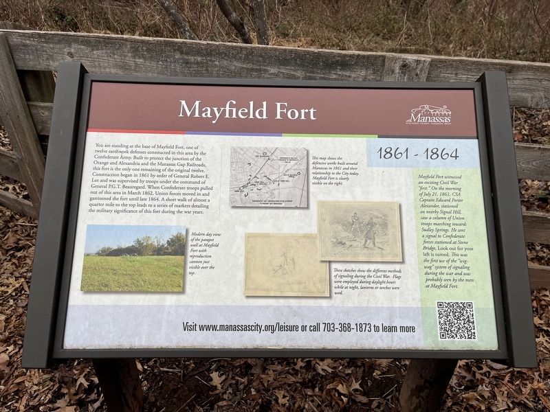
You are standing at the base of Mayfield Fort, one of twelve earthwork defenses constructed in this area by the Confederate Army. Built to protect the junction of the Orange and Alexandria and Manassas Gap Railroads, this fort is the only one remaining of the original twelve. Construction began in 1861 by order of General Robert E. Lee and was supervised by troops under the command of General P.G.T. Beauregard. When Confederate troops pulled out of this area in March 1862, Union forces moved in and garrisoned the fort until late 1864. A short walk of almost a quarter mile to the top leads to a series of markers detailing the military significance of this fort during the war years.
[Sidebar:]
Mayfield Fort witnessed an exciting Civil War "first." On the morning of July 21, 1861, CSA Captain Edward Porter Alexander, stationed on nearby Signal Hill, saw a column of Union troops marching towards Sudley Springs. He sent a signal to Confederate forces stationed at Stone Bridge, Look out for your left is turned. This was the first use of the "wig-wag" system of signaling during the war and was probably seen by the men at Mayfield Fort.
[Captions:]
Modern day view of the parapet wall at Mayfield Fort with reproduction cannon just visible over the top.
This map shows the defensive works built around Manassas in 1861 and their relationship to the City today. Mayfield Fort is clearly visible on the right.
These sketches show the different methods of signaling during the Civil War. Flags were employed during daylight hours while at night, lanterns or torches were used.
Erected by City of Manassas, Virginia.
Topics and series. This historical marker is listed in these topic lists: Communications • Forts and Castles • Railroads & Streetcars • War, US Civil. In addition, it is included in the Manassas Gap Railroad, and the Orange and Alexandria Railroad series lists. A significant historical month for this entry is March 1862.
Location. 38° 45.288′ N, 77° 27.191′ W. Marker is in Manassas, Virginia. Marker is on Battery Heights Boulevard south of Quarry Road, on the right when traveling north. Touch for map. Marker is at or near this postal address: 8401 Quarry Rd, Manassas VA 20110, United States of America. Touch for directions.
Other nearby markers. At least 8 other markers are within walking distance of this marker. Building Mayfield Fort (about 400 feet away, measured in a direct line); Building the Fort System (about 400 feet away); Why the Forts? (about 400 feet away); Role of Mayfield in Battle of First Manassas (about 400 feet away); Camps of Instruction
Related marker. Click here for another marker that is related to this marker. This marker has replaced the linked marker.
Credits. This page was last revised on January 8, 2023. It was originally submitted on January 8, 2023, by Devry Becker Jones of Washington, District of Columbia. This page has been viewed 128 times since then and 33 times this year. Photos: 1, 2. submitted on January 8, 2023, by Devry Becker Jones of Washington, District of Columbia.

