5 entries match your criteria.
Related Historical Markers
To better understand the relationship, study each marker in the order shown.
By David Seibert, June 20, 2009
Hightower Trail Marker
SHOWN IN SOURCE-SPECIFIED ORDER
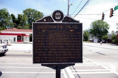
| | This road is a portion of Hightower Trail, old Indian path to Etowah River, which ran from High Shoals of the Appalachee westward to Shallow Ford on the Chattahoochee. It formed a boundary between Cherokee lands to the north and Creek lands to the . . . — — Map (db m33434) HM |
| | Hightower (Etowah) Trail, one of the best marked Indian Trails in Georgia, was a much used crossover between two of the noted Trading Paths radiating from Augusta. Recognized as a former boundary between Cherokee and Creek lands, a part of it . . . — — Map (db m33433) HM |
| | Hightower (Etowah) Trail, one of the best marked Indian trails in Georgia, and a main road along which many settlers built their homes until the 1840’s, crossed this highway near here on its way to a nearby ford on the Chattahoochee River. A . . . — — Map (db m33435) HM |
| | At this point the noted Hightower (Etowah) Indian Trail crossed today’s Azalea Drive. With connections from Charleston, via Augusta, the old thoroughfare ran through this section to reach the Indian towns of present - day northwest Georgia. The . . . — — Map (db m33436) HM |
| | Already a well-established route in the 1700s, the Hightower Trail was a major Indian thoroughfare and part of a network of trails connecting Augusta with the Etowah River area and Alabama. The path crossed the Chattahoochee River at a shallow ford . . . — — Map (db m33432) HM |
Apr. 19, 2024