4 entries match your criteria.
Related Historical Markers
Cumberland Gap Civil War Defenses
By Craig Swain, September 5, 2010
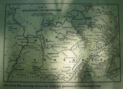
Map of Kentucky and Tennessee
SHOWN IN SOURCE-SPECIFIED ORDER
| | For the North, Cumberland Gap was a natural invasion route into the South - providing access to vulnerable railroads and valuable minerals and salt works in East Tennessee and southwest Virginia. For the South, the Gap was a gateway for an . . . — — Map (db m207774) HM |
| | During the Civil War this earthwork - called Fort Rains by the Confederates and Fort McCook by the Federals - was one of many fortifications ringing Cumberland Gap. These defenses were considered too formidable to be taken by direct assault, which . . . — — Map (db m207773) HM |
| | "Cumberland Gap is the strongest position I have ever seen except Gibraltar." These were Union General George W. Morgan's words after viewing the fortification around the Gap. On June 19, 1862, he wrote to Secretary of War Edwin M. Stanton, "The . . . — — Map (db m207707) HM |
| | A natural thoroughfare through the Appalachian Mountain barrier, Cumberland Gap assumed great strategic importance in the Civil War. Both sides sought to control the Gap. It changed hands three times, but no battles were fought. Troops garrisoned . . . — — Map (db m207711) HM |
Apr. 24, 2024