3 entries match your criteria.
Related Historical Markers
This is a list of Ice Age National Scientific Reserve or Trail markers.
By Robert L Weber
Trail Marker
SHOWN IN SOURCE-SPECIFIED ORDER
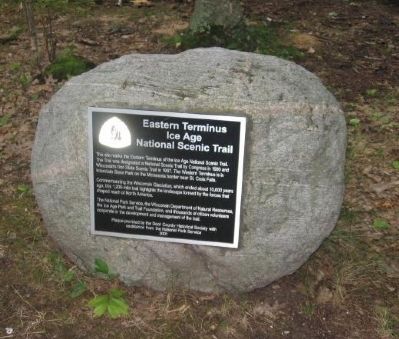
| | This site marks the Eastern Terminus of the Ice Age National Scenic Trail. The Trail was designated a National Scenic Trail by Congress in 1980 and Wisconsin's first State Scenic Trail in 1987. The Western Terminus is in Interstate State Park on . . . — — Map (db m39249) HM |
| On Funnel Road north of U.S. 12, on the right when traveling north. |
| | [graphic of] Prominent Glacial Features
Deep winter in Wisconsin lasts about three months. But during the last two million years, dramatic shifts in climate produced periods with longer winters. These cold spells lasted thousands of . . . — — Map (db m40197) HM |
| Near South Lake Road, 3 miles west of Wisconsin Highway 113, on the right when traveling west. |
| | [A map in the upper left corner of the marker shows the extent of glaciation over North America and Wisconsin's position. Below it, a map shows the extent of glaciation in Wisconsin, with the locations of National Scientific Reserve Sites . . . — — Map (db m38943) HM |
Apr. 19, 2024