On Monument Drive at Monument Court, on the left when traveling west on Monument Drive.
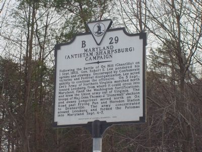
Following the Battle of Ox Hill (Chantilly) on 1 Sept. 1862, Gen. Robert E. Lee pondered his options and strategy. Encouraged by Confederate victories and Federal disorganization, Lee acted quickly to continue the offensive. On 3 Sept., Lee's Army . . . — — Map (db m111) HM
On Leesburg Pike (Virginia Route 7) near Northfalls Court, on the right when traveling west. Reported permanently removed.
Here Lee entered this road from Ox Hill, September 3, 1862, and turned West toward Leesburg. Crossing the Potomac at White's Ford, the army entered Maryland, September 5-6, 1862. — — Map (db m1098) HM
On Loudoun Street SW, on the right when traveling west.
“Leesburg! Paradise of the youthful warrior! Land of excellent edibles and beautiful maidens!” — so wrote a Confederate artilleryman in late 1861. A year later, a northern correspondent found Leesburg a weary town full of . . . — — Map (db m1544) HM
On Loudoun Street SW, on the right when traveling west.
Fresh from the victory at the Second Battle of Manassas
General Robert E. Lee’s Army of Northern Virginia crossed the Potomac River on September 1-6, 1862,
to bring the Civil War to Northern soil and to recruit sympathetic Marylanders. Union Gen. . . . — — Map (db m1110) HM
On Tutt Lane (Route 740) west of Victory Lane, on the left when traveling west.
Fresh from victory at the Second Battle of Manassas, Gen. Robert E. Lee’s Army of Northern Virginia crossed the Potomac River on September 4–6, 1862, to bring the Civil War to Northern soil and to recruit sympathetic Marylanders. Union Gen. . . . — — Map (db m1220) HM
On Tutt Lane (Virginia Route 740) west of Victory Lane, on the left when traveling west.
On September 1, 1862, Col. Thomas Munford, commander of the Confederate 2nd Virginia Cavalry (163 men), was ordered to Leesburg to destroy a body of Union Cavalry—the locally raised Independent Loudoun Virginia Rangers—who were harassing southern . . . — — Map (db m1219) HM
On James Monroe Highway (U.S. 15) at Spinks Ferry Road (Virginia Route 657), on the right when traveling north on James Monroe Highway.
Here Lee turned east to the Potomac, crossing at White's Ford, September 6, 1862, in his invasion of Maryland. Jubal A. Early, returning from his Washington raid, crossed the river at White’s Ford, July 14, 1864. — — Map (db m1609) HM
On the White’s Ferry parking lot near White"s Ferry Road (Maryland Route 107).
Fresh from the victory at the Second Battle of Manassas
General Robert E. Lee’s Army of Northern Virginia crossed the Potomac River on September 1-6, 1862,
to bring the Civil War to Northern soil and to recruit sympathetic Marylanders. Union Gen. . . . — — Map (db m167962) HM
Near Whites Ferry Road, 0.1 miles south of River Road, on the right when traveling west.
The serenity of the Maryland countryside was
shattered on September 4-6, 1862, as 35,000 Confederate soldiers of the Army of Northern Virginia
waded across the Potomac River. Gen. Robert E. Lee, hoping to rally support in the divided
state, sent . . . — — Map (db m173131) HM
On Darnestown Road (Maryland Route 28) at Whites Ferry Road (Maryland Route 107), on the right when traveling west on Darnestown Road.
An old ferry and ford across the Potomac River often used during the war between the states by Confederate forces under Generals Robert E. Lee, Jubal Early, J.E.B. Stuart and others during campaigns and raids in Maryland. — — Map (db m1680) HM
Near Martinsburg Road, 2.5 miles west of Darnestown Road (Maryland Route 28), on the right when traveling west. Reported permanently removed.
A wing of Gen. Robert E. Lee’s Army of Northern Virginia commanded by Gen. James Longstreet, as well as part of Gen. J.E.B. Stuart’s cavalry, crossed into Maryland just south of here on September 5-6, 1862. Other parts of the 40,000-man force, . . . — — Map (db m812) HM
On Whites Ferry Road (Maryland Route 107) at Martinsburg Road, on the left when traveling west on Whites Ferry Road.
About 2 miles northwest was White’s Ford. This Potomac crossing was used by Gen. R. E. Lee entering Maryland in September, 1862, and Generals J.E.B. Stuart and Jubal A. Early returning to Virginia in 1862 and 1864, respectively. — — Map (db m811) HM
Near Mouth of Monocacy Road at Dickerson Road (Maryland Route 28).
Confederate Gen. D. H. Hill’s division crossed the Potomac at Point of Rocks on September 4, 1862, and marched south to clear Union forces from the area. His men breached and drained the Chesapeake and Ohio Canal at several places, burned canal . . . — — Map (db m65210) HM
On Dickerson Road (State Highway 28), on the right when traveling west.
Fresh from victory at the Second Battle of Manassas, Gen. Robert E. Lee’s Army of Northern Virginia crossed the Potomac River on September 4–6, 1862, to bring the Civil War to Northern soil and to recruit sympathetic Marylanders. Union Gen. . . . — — Map (db m4028) HM
On Buckeystown Pike (Maryland Route 85), on the right when traveling north.
On Saturday, September 6, 1862, the Army of Northern Virginia was spread along the entire length of Buckeystown Turnpike all the way to Frederick. The soldiers camped in the fields on either side of the road on the evenings of September 5-6, and by . . . — — Map (db m152272) HM
On Michael's Mill Road (Maryland Route 880) at Fingerboard Road (Maryland Route 80), on the right on Michael's Mill Road.
On the south end of this park, the road from Urbana to Buckeystown crossed the Monocacy River over a stone bridge. Some of the Confederate troops camped here on September 6, 1862, while some crossed the bridge to bivouac on a knoll overlooking the . . . — — Map (db m1737) HM