4 entries match your criteria.
Related Historical Markers
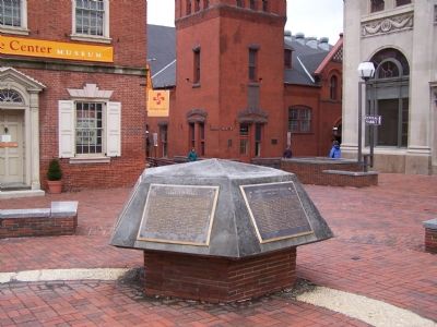
Lancaster markers displayed together.
By William Pfingsten, February 2, 2008
Five Markers
SHOWN IN SOURCE-SPECIFIED ORDER
| | Indian wigwams, a hickory tree, and a spring - that was old center square "Hickory Town" prior to 1730. In that year, however, significant changes occurred as Andrew and James Hamilton laid out Lancaster Townstead with an open square. Streets . . . — — Map (db m5151) HM |
| | King Street
Throughout Lancaster City's history, King Street has been a major thoroughfare between Philadelphia and points west. In 1733 work commenced on the King's Highway, now Route 340. This highway began at the square, extended eastward . . . — — Map (db m157545) HM |
| | The red brick market building directly before you is the oldest publicly owned, continually operated market in the United States, representing a Lancaster tradition since 1730. This building, which was constructed in 1889 by John Berger, is . . . — — Map (db m157468) HM |
| | Directly before you in the square stands the soldiers and sailors monument, erected in 1874 by the Lancaster County Monumental Association to honor the brave men and women of Lancaster County who died to save the Union during the Civil War. The . . . — — Map (db m5129) HM |
Apr. 18, 2024