U.S.A. Battery I, 1st U.S. Artillery, Lieut. Geo. A. Woodruff, U.S.A. Commanding. (September 17, 1862.) Between 9 and 10 a.m., Battery I, 1st Artillery, advancing by the Smoketown Road, passed through the East Woods to the assistance of the . . . — — Map (db m185587) HM
U.S.A. Batteries A and C 4th U.S. Artillery. Lieut. Evan Thomas, U.S.A., Commanding. (September 17, 1862.) Batteries A and C (consolidated), 4th U.S. Artillery (6 guns), relieved Battery I, 1st U.S. Artillery just north of this point and went . . . — — Map (db m6032) HM
U.S.A. Battery D, 2nd U.S. Artillery. Lieut. Edward B. Williston, U.S.A., Commanding. (September 17, 1862.) Battery D, 2nd U.S. Artillery, moved from its bivouac near Crampton's Pass on the morning of the 17th and went into position south of the . . . — — Map (db m6034) HM
U.S.A. Battery F, 5th U.S. Artillery. Lieut. Leonard Martin, U.S.A., Commanding. (September 17, 1862.) Early in the morning of the 17th, Battery F, 5th U.S. Artillery, generally known as Ayers' Battery, moved with Smith's Division, Sixth Army . . . — — Map (db m6030) HM
Maryland Battery A 1st MD Light Artillery 1st Slocum's Division 6th Franklin's Corps The battery under the command of Capt. John W. Wolcott occupied a line 100 feet in rear of this marker and facing Dunkard Church. Loss 1 killed, 11 wounded. The . . . — — Map (db m6035) HM
September 17, 1862 —————— From a position about 60 yards south of this point the battery, between 2 and 3 p.m., engaged and silenced the Confederate artillery around the Dunkard Church. — — Map (db m6036) HM
Union soldiers described the fighting at the Mumma farm: "I do not see how any of us got out alive. The shot and shell fell about us thick and fast, I can tell you, but I did not think much about getting shot after the first volley." "Just in . . . — — Map (db m6184) HM
This cemetery and the farm buildings to your right were part of Samuel and Elizabeth Mumma's farm in 1862. Warned of the coming battle, the Mummas and their ten children fled to safety. Fearful that Union sharpshooters would use the farm . . . — — Map (db m20715) HM
This portion of the historic Mumma Farm Lane looked much the same in 1862. Confederate soldiers burned the farm buildings to prevent their use by Federal sharpshooters. Only the white-washed stone springhouse (on the left) survived as does this . . . — — Map (db m6981) HM
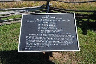
Second Corps, with 15,000 soldiers was the largest corps in the Union Army of the Potomac. Its lead division went into the West Woods alone. The other two divisions strayed to the south and passed in front of this point, marching from left to right. . . . — — Map (db m6212) HM
About 9:30 a.m. the battle started to shift from the north end of the battlefield toward the Sunken Road, 180 yards to your right (south). Two divisions from the Union Second Corps moved across the Mumma and Roulette farm fields in front of you. . . . — — Map (db m20716) HM