6 entries match your criteria.
Related Historical Markers
Virtual Tour by Markers of the Battle of Corydon
By Ginger Drenning, July 16, 2008
Presbyterian Church
SHOWN IN SOURCE-SPECIFIED ORDER
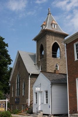
| | Organized under Louisville Presbytery, Synod of Kentucky, January 1819 by Rev. John Finley Crowe who later founded Hanover College. Early Church services were held in homes and in State Capitol prior to building first church 1826. Original church . . . — — Map (db m9713) HM |
| | A force of about 400, Indiana militia and citizen volunteers commanded by Col. Lewis Jordan, engaged John Hunt Morgan's raiders, 2,400 cavalry, along a wooded ridge a mile south of Corydon. The determined Hoosier defense caused General Duke, . . . — — Map (db m9636) HM |
| |
Site of the
Battle
of
Corydon
July 9 - 1863 — — Map (db m9635) HM |
| | Civil War cannon has been dedicated to the memory of Arville L. Funk: historian, author, lawyer, teacher, civic and church leader This six-pound field gun is similar to those used by General John Hunt Morgan’s Raiders and the Harrison County Home . . . — — Map (db m9687) HM |
| | (Confederate Side of Marker):
Morgan's Confederate Dead
Pvt. Greene Bottomer
Pvt. John Dunn Pvt. Albert Womack Eight Unknown Dead Forty Wounded
(On Marker Base): Park Ground Donated by C. B. Hays Family
(Northern Side . . . — — Map (db m9683) HM |
| | On July 9, 1863, along this wooded ridge - - - from the “Laconta” Road extending across the “Mauckport” Pike to the old “New Amsterdam” Road - - - occurred the only Civil War battle in Indiana. It was between Gen. . . . — — Map (db m9721) HM |
Apr. 19, 2024