Forest in Bedford County, Virginia — The American South (Mid-Atlantic)
Transforming a Plantation into a Private Retreat, 1806—1826
Inscription.
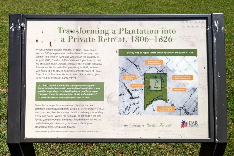
When Jefferson became president in 1801, Poplar Forest was a 4,500-acre plantation with at least 60 enslaved men, women and children living and working on the property. In August 1806, President Jefferson visited Poplar Forest to help his bricklayer, Hugh Chisolm, complete the intricate octagonal foundation. By the end of his presidency in 1809, Jefferson was finally able to stay in his nearly complete house at Poplar Forest for the first time. He would spend his remaining years perfecting his Bedford County retreat.
To further arrange the space around his private retreat, Jefferson had enslaved laborers build a 61 -acre curtilage, a legal term that describes the enclosed land immediately surrounding a dwelling house. Within the curtilage, he set aside a 10-acre fenced yard surrounding the retreat house that contained the carefully designed pleasure grounds with plantings of ornamental trees, shrubs and flowers.
"l … have laid off a handsome curtilage connecting the house with the Tomahawk, have inclosed and divided it into suitable appendages to a Dwelling house, and have begun it's improvement by planting trees of use and ornament."
—Thomas Jefferson to John Wayles Eppes; April 18, 1813
(captions)
Survey map of Poplar Forest drawn by Joseph Slaughter in 1813
Background image by Thomas Jefferson, undated; courtesy of Massachusetts Historical Society
Erected by Thomas Jefferson’s Poplar Forest, Daughters of the American Revolution.
Topics and series. This historical marker is listed in these topic lists: African Americans • Architecture. In addition, it is included in the Daughters of the American Revolution series list. A significant historical year for this entry is 1806.
Location. 37° 20.894′ N, 79° 15.901′ W. Marker is in Forest, Virginia, in Bedford County. Marker can be reached from the intersection of Poplar Forest Drive and Foxhall Drive, on the left when traveling east. Touch for map. Marker is at or near this postal address: 1542 Bateman Bridge Road, Forest VA 24551, United States of America. Touch for directions.
Other nearby markers. At least 8 other markers are within 4 miles of this marker, measured as the crow flies. Poplar Forest Planting Memorandum 1812 (within shouting distance of this marker); Mounds Made of Ideas and Sweat (within shouting distance of this marker); "A Culture Productive of Infinite Wretchedness” (about 300 feet away, measured in a direct line); Crafting a Masterpiece, Longing for Home (about 300 feet away); “I have this summer built a wing of offices...” (about 400 feet away); Plantation Worker Housing (about 400 feet away);
St. Stephen's Church (approx. 2.4 miles away); Samuel Miller (approx. 3.2 miles away). Touch for a list and map of all markers in Forest.
Related marker. Click here for another marker that is related to this marker. Old Marker At This Location titled "Commemorating Lewis and Clark".
Also see . . . Thomas Jefferson’s Poplar Forest. (Submitted on May 18, 2022.)
Credits. This page was last revised on May 19, 2022. It was originally submitted on May 18, 2022, by Bernard Fisher of Richmond, Virginia. This page has been viewed 443 times since then and 27 times this year. Photos: 1, 2. submitted on May 18, 2022, by Bernard Fisher of Richmond, Virginia.

