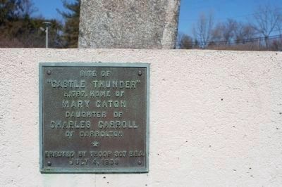
A gift from Charles Carroll of Carrollton, Castle Thunder, the home of Richard and Mary Carroll Caton, stood on this site from 1787 to 1906.
The 7-mile Frederick Turnpike stone marker of 1804 was moved here from its original position 3/10 . . . — — Map (db m4910) HM
This 1877 “Plan of Catonsville” lays outs all the possibilities of an energetic and emerging suburb of Baltimore, only eight miles, or a one-day carriage ride, to the east. The centerpiece of the town is the Frederick Turnpike, part of the road . . . — — Map (db m5500) HM
The reign of stagecoaches and Conestoga Wagons on the Baltimore and Frederick-Town Turnpike only lasted seventy years. Omnibuses, attached to teams of four horses, began rolling out from Baltimore to Catonsville in 1862.
The Catonsville Short . . . — — Map (db m5536) HM
The Ellicott brothers constructed what became the first leg of the Baltimore and Frederick-Town Turnpike to get their flour to market in Baltimore. By 1787, they cut a new road east through the forests to shorten the trip to the city. This route . . . — — Map (db m128248) HM
Mount Airy was first settled along what is now Ridgeville Boulevard. With the construction of the Old National Pike (Route 40) in the 1730s, Ridgeville became a rest stop and overnight lodging for travelers on the road. In 1831 the Baltimore and . . . — — Map (db m199372) HM
In 1839, the Baltimore and Ohio Railroad extended its line through Mount Airy Cut, and a village soon developed here. During the Civil War, Co. K, 14th New Jersey Infantry, guarded the railroad and National Road at Mount Airy. Pine Grove Chapel, . . . — — Map (db m201590) HM
Here at Milestone 31, about 130 feet southeast of its original location, the Baltimore and Frederick-Town Turnpike created two towns as it moved west. Both Parrsville and Ridgeville are now a part of Mount Airy. Parrsville, to the east, was . . . — — Map (db m4933) HM
The National Road has borne witness to many notorious comings and goings. The quiet atmosphere you’ll find at Hagan’s Tavern today is quite different from the raucous bawdiness of yesteryear. This tavern was a “place where the old bloats of . . . — — Map (db m167094) HM
The Square Corner, at the intersection of Patrick and Market Streets, has long been the commercial and financial heart of Frederick. It is here that the National Road meets several important north-south roads that lead to Pennsylvania, Virginia, and . . . — — Map (db m2748) HM
This part of downtown Frederick has long been a place of lodging and hospitality for travelers along the National Road. Kimball's Inn, Talbott's Tavern, the City Hotel and the Francis Scott Key Hotel have occupied this site for over two hundred . . . — — Map (db m104243) HM
This part of downtown Frederick has long been a place of lodging and hospitality for travelers along the National Road. Kimball's Inn, Talbott's Tavern, the City Hotel and the Francis SCott Key Hotel have occupied this site for over two hundred . . . — — Map (db m243565) HM
The man Americans honor as the author of "The Star-Spangled Banner" began his life and career in Frederick County, Maryland. Here he first learned the American values that guided his life.
Key was a child of the American Revolution, and saw . . . — — Map (db m198000) HM
Frederick Town was founded in 1745 when Daniel Dulany the Elder carved out an eastern portion of his 7,000 acre parcel patented as "Tasker's Chance." The town was then laid out in an orderly grid with Patrick Street designated as the east-west . . . — — Map (db m2805) HM
In 1826, Jacob Engelbrecht moved to the house across the street near Carroll Creek. He began reporting on the National Road cavalcade that was going by his front door. His priceless diary recorded everything he saw. Travelers he observed included: . . . — — Map (db m2706) HM
In 1800, travelers expected to ford rivers or use ferries that were slow and often risky in bad weather. The Baltimore and Frederick-Town Turnpike Company, building the first leg of the National Road in 1805, set out to revolutionize American . . . — — Map (db m2321) HM
In 1800, travelers expected to ford rivers or use ferries that were slow and often risky in bad weather. The Baltimore and Frederick-Town Turnpike Company, building the first leg of the National Road in 1805, set out to revolutionize American . . . — — Map (db m243580) HM
The stone demijohn and memorial plaque, placed by the Sons of the American Revolution, were originally located on a bridge crossing the Monocacy River about 2 miles east of this site. The stone bridge of four arches and two 65-foot spans was . . . — — Map (db m136898) HM
As the Civil War approached, the citizens of Middletown read about the coming conflict in the town newspaper, The Valley Register. Some attended patriotic rallies, while others found it safer to conceal their allegiances. Soldiers from many . . . — — Map (db m143918) HM
Noted for the tall white spire of the Zion Lutheran Church, Middletown has been framed by its picturesque valley for over two centuries. German Protestants, fleeing persecution in Europe, founded the community before the American Revolution. . . . — — Map (db m415) HM
After Confederate Gen. Robert E. Lee's stunning victory at Chancellorsville in May 1863, he led the Army of Northern Virginia west to the Shenandoah Valley, then north through central Maryland and across the Mason-Dixon Line into . . . — — Map (db m203059) HM
This view of downtown Middletown was taken from the towering steeple of the Zion Lutheran Church across the street behind you. This remarkable image highlights the historic National Road—dirt at the time—running eastward toward Frederick, and (to . . . — — Map (db m219995) HM
Crisscrossed By Transportation Routes, Home To America's Earliest Industries, And Meeting Place For National Leaders, Maryland's Appalachian Region Has Been Pivotal In The Growth Of The Country
Throughout its history, the nation has . . . — — Map (db m116529) HM
Crisscrossed By Transportation Routes, Home To America's Earliest Industries, And Meeting Place For National Leaders, Maryland's Appalachian Region Has Been Pivotal In The Growth Of The Country
Throughout its history, the nation has . . . — — Map (db m196233) HM
The Historic National Road — "The Road that Built the Nation" — parallels Interstate 70, connecting western settlements across the Appalachian Mountains with eastern ports since 1806. — — Map (db m116490) HM
The Historic National Road — "The Road that Built the Nation" — parallels Interstate 70, connecting western settlements across the Appalachian Mountains with eastern ports since 1806. — — Map (db m196232) HM
Looking more like an ancient tombstone, the stone marker at the bottom of the hill before you, tucked inside the guardrail, was once used to denote mileage to Baltimore along the Baltimore and Frederick-Town Turnpike, also known as the old National . . . — — Map (db m5404) HM
As Fredericktown was born in 1745, German farmers were already hauling their grain to the port of Baltimore. By the 1780s, new communities were springing up along
busy wagon routes. Two speculators, Nicholas Hall and William Plummer, competed to . . . — — Map (db m167304) HM
As Fredericktown was born in 1745, German farmers were already hauling their grain to the port of Baltimore. By the 1780s, new communities were springing up along busy wagon routes. Two speculators, Nicholas Hall and William Plummer, competed to . . . — — Map (db m243567) HM
As early as 1750, Robert Turner bought land here on the top of South Mountain. The date of construction is unknown, but by 1790 a full-fledged inn was in operation at “Turner’s Gap.” Since then, the building has been in almost continuous use as . . . — — Map (db m1600) HM
As early as 1750, Robert Turner bought land here on the top of South Mountain. The date of construction is unknown, but by 1790 a full-fledged inn was in operation at “Turner’s Gap.” Since then, the building has been in almost continuous use as . . . — — Map (db m243581) HM
The land occupied by Wilderness Voyageurs was once the site of the livery stable for the Riverside Hotel. The house pictured above was the home of Captain Elijah Monroe Friend, grandson of Gabriel Friend, son of John Friend the first white . . . — — Map (db m153156) HM
As they climbed into the mountains west of Frostburg, travelers entered the longest straightaway on the National Road between Cumberland and Wheeling, West Virginia. They marveled at this long ribbon of road and christened it the "Long Stretch." . . . — — Map (db m134376) HM
Castleman's River Bridge
(Formerly "Little Youghiogeny")
Erected 1813 by David Shriver, Jr., Sup't of the "Cumberland Road" (The National Road). This 80 foot span was the largest stone arch in America at the time. It was continuously . . . — — Map (db m100) HM
The Casselman Inn. You are standing in front of the Casselman Inn, which was opened in 1842 by Solomon Sterner. This establishment has also been known as Sterner House, Drovers' Inn, Farmers' Hotel and Dorsey Hotel. There was a large outdoor . . . — — Map (db m360) HM
When the National Road came through here in 1815, this settlement was a half mile away along the old Braddock Road. This “New Grantsville” developed just west of the Casselman Bridge, completed a few years earlier. About a dozen . . . — — Map (db m477) HM
(Logo for Mountain Maryland Gateway to the West, Garrett County)
(7 small color images of structures and landscapes. 1 large color image of the Cassleman River Bridge.)
Transportation
Transportation features include Garrett . . . — — Map (db m168096) HM
You have reached the highest point on the National Road. Here, in the far western mountains of Maryland is the backbone of eastern America. In 1817, the National Road construction crew took on the challenge of crossing this tough terrain by . . . — — Map (db m5409) HM
You have reached the highest point on the National Road. Here, in the far western mountains of Maryland is the backbone of eastern America. In 1817, the National Road construction crew took on the challenge of crossing this tough terrain by . . . — — Map (db m236979) HM
This was the site of a blacksmith ship for shoeing horses and servicing stagecoaches, freighters and Conestogas on the National Road. Up to fourteen coaches per day, each way, passed here during the peak season. Traffic was often so heavy that the . . . — — Map (db m137552) HM
This humble log cabin is a rare survivor of a common dwelling built by early settlers on the Allegheny frontier. Built after 1813 as a two-story log building, its large size has led some to believe it was once used as a tavern, giving respite to . . . — — Map (db m4921) HM
This humble log cabin is a rare survivor of a common dwelling built by early settlers on the Allegheny frontier. Built after 1813 as a two-story log building, its large size has led some to believe it was once used as a tavern, giving respite to . . . — — Map (db m243583) HM
In 1806 Congress authorized and funded the construction of a National Road from Cumberland, MD to the Ohio River at Wheeling, WV. This National Road, also known as the National Pike or Cumberland Road, was our nation's first highway and truly the . . . — — Map (db m84794) HM
Here in America's first interstate highway enters Pennsylvania. The National Road started in Cumberland, connected to a series of privately funded turnpikes from Baltimore, and eventually wound its way through four states to Illinois. . . . — — Map (db m235243) HM
Granstville's Main Street, designated today as Alt. Route 40, was once part of the National Road, the country's first federally funded highway. Visit our Town Park to learn more about the history of the National Road.
Traffic on the National . . . — — Map (db m177981) HM
Built in 1820 in Grantsville, Md. as a stagecoach stop on the Old National Pike. Food, drink, sleeping accommodations and tickets were for sale here.
Reconstructed at Penn Alps in 1967. — — Map (db m137554) HM
“. . . so many happy people, restless in the midst of abundance.” —Alexis de Tocqueville, 1840.
Americans are an adventurous people. From
past to present, they have used feet, horses,
wagons, stagecoaches, canals, . . . — — Map (db m2171) HM
Methodist churches were a source of inspiration for the budding African-American community as people moved westward along the Baltimore and Frederick-Town Turnpike, part of the National Road system. Both enslaved and free African-Americans . . . — — Map (db m188490) HM
You are standing at Mile Marker 14, a historic stone marker located at the intersection of US Route 40 and MD 144, formerly known as the Pine Orchard hamlet. Although it has worn away over time, hand-chiseled letters read 14 M To B, meaning 14 . . . — — Map (db m179225) HM
Ellicott City’s Main Street is the National Pike, part of the road system that moved Americans west. Only two decades after the road was constructed, a new transportation rival appeared. In 1831, America’s first railroad, the Baltimore & Ohio, . . . — — Map (db m720) HM
Ellicott City’s Main Street is the National Pike, part of the road system that moved Americans west. Only two decades after the road was constructed, a new transportation rival appeared. In 1831, America’s first railroad, the Baltimore & Ohio, . . . — — Map (db m243568) HM
This marker stands on a part of the right of way of the historic and fabled National, or Cumberland Road. Commencing in 1806 it was built in segments by city, state, federal, and private means and was the first great commercial and travel link from . . . — — Map (db m131) HM
“New Lisbon” was established by Quaker Caleb Pancoast in 1802, who saw both need and opportunity to service travelers along the length of the National Pike. He also welcomed all religious denominations into his home, and allowed it to be used as a . . . — — Map (db m5744) HM
In the early 1800s, as settlers spread west from the Chesapeake Bay, the farming community of Poplar Springs grew up around the Baltimore and Frederick-Town Turnpike, part of the system of roads making up the National Road. An endless parade of . . . — — Map (db m5024) HM
Methodist churches were a source and inspiration for the budding African-American community as people moved
westward along the Baltimore and Frederick-Town Turnpike, part of the National Road system. Both enslaved and free African-Americans . . . — — Map (db m5745) HM
“. . . so many happy people, restless in the midst of abundance.” —Alexis de Tocqueville, 1840.
Americans are an adventurous people. From
past to present, they have used feet, horses,
wagons, stagecoaches, canals, . . . — — Map (db m1911) HM
The National Road from Baltimore to Cumberland was comprised of a series of privately funded turnpikes. By 1822, the road was complete except for the ten miles between Boonsboro and Hagerstown. In August of the year, under pressure from the state . . . — — Map (db m1162) HM
The portion of this highway from the west end of the Conococheague bridge to Cumberland (40 miles) was built between 1816 and 1821. The banks of Maryland financed it by purchase of the stock. — — Map (db m699) HM
“The citizens at all times aim to be surpassed by no other town in the County.” –Martin Lehr, Clear Spring historian, 1890’s.
In 1821, Martin Myers chose a site that straddled a “clear spring” at the foot . . . — — Map (db m694) HM
The Miller Hotel was one of the most popular destinations along the National Road in Washington County. Traveler T.B. Seabright recalled in 1894 “There were large rooms adapted to dancing purposes, and young men and maidens of the vicinity . . . — — Map (db m60556) HM
"You wonder if we have it. We wonder where it is. You wonder how we found it!” That is how Janice Keefer remembered her father’s store during the 42 years that Dorsey Martin conducted business here. Originally opened by Rufus Wilson in 1850, the . . . — — Map (db m4932) HM
When the National Road was completed through Funkstown in 1823, a rush of “stagecoaches and wagon teams, droves of cattle, teamsters and travelers” flooded through the town. Although Baltimore was seventy miles to the east, the Funkstown city . . . — — Map (db m2007) HM
1814
On January 26, the Maryland General Assembly officially changes the town's name from 'Elizabeth Town' to 'Hager's Town' and re-incorporates Elizabeth Town under this new name.
1814
The "Hagerstown Blues" cavalry fights at . . . — — Map (db m146004) HM
Following Jonathan Hager’s arrival in 1739, German and Scots-Irish immigrants settled in Maryland’s Great Valley, developing prosperous farms. By the mid 1790’s,
agriculture was booming and the region needed a way to get its products to market. . . . — — Map (db m6532) HM
The National Road was the first Federally-funded road project authorized by Congress. A gateway to the western frontier, it began in Cumberland and extended to Vandalia, Illinois. Heavily used from the time it opened, it was America's first . . . — — Map (db m148826) HM
“After the exhilaration of a gallop down the mountain without breaks, what appetite would not be set on edge, what refinement of palate displeased by venison cutlets, or even ham and eggs?”
Harper’s Magazine, . . . — — Map (db m5931) HM
“After the exhilaration of a gallop down the mountain without breaks, what appetite would not be set on edge, what refinement of palate displeased by venison cutlets, or even ham and eggs?”
Harper’s Magazine, . . . — — Map (db m199838) HM
The significance of this structure lies both in its history and architecture. It is one of the few remaining “toll houses” along the old National Road. The National Road was chartered between Hancock and Cumberland in 1819 and completed in 1822, . . . — — Map (db m5799) HM
Rainwater enters the outcropping sandstones of Sideling Hill and collects in what is termed an aquifer. In this highway cut, the water runs out at the bottom of the fractured sandstone layers because it cannot go through the dense claystone below. . . . — — Map (db m5543) HM
“. . . so many happy people, restless in the midst of abundance.” —Alexis de Tocqueville, 1840.
Americans are an adventurous people. From
past to present, they have used feet, horses,
wagons, stagecoaches, canals, . . . — — Map (db m824) HM
“. . . so many happy people, restless in the midst of abundance.” —Alexis de Tocqueville, 1840.
Americans are an adventurous people. From
past to present, they have used feet, horses,
wagons, stagecoaches, canals, . . . — — Map (db m830) HM
Home of Brig. Gen. Otho Holland Williams, Revolutionary War hero and founder, 1786, of Williamsport, and of Col. Elie Williams, president of commission to lay out National Road and chief surveyor Chesapeake and Ohio Canal. President George . . . — — Map (db m3909) HM
Built in 1819, this five-arch structure, named for nearby village, was first stone bridge in Washington County. Erected by Silas Harry at cost of $12,000, it was a major improvement to road system between Baltimore and Cumberland, providing . . . — — Map (db m697) HM
“Keep these bridges in proper repair and they will last as long as any. They have stood many hard knocks for a long time.” —Elmer E. Piper, Washington County Surveyor, 1920s.
The earliest highway signs along the National Road (Route 40) in Ohio were milestones located at one-mile intervals along the north side of the roadway. Each stone indicated the distance to Cumberland, Maryland, the eastern terminus of the National . . . — — Map (db m78496) HM
The National Road crosses six states from Baltimore, Maryland, to East St. Louis, Illinois. The road fulfilled the dreams of George Washington and Thomas Jefferson to build an all-weather route across the Allegheny Mountains to connect the Eastern . . . — — Map (db m132703) HM
Blaine Hill "S" Bridge
The first Blaine Hill Bridge was constructed in 1828 as part of the National Road, the nation's first federally funded highway. This three-arch S-shaped structure, 345 feet in length, spans Wheeling Creek (a tributary of . . . — — Map (db m12618) HM
Colonel Ebenezer Zane, one of the founders of Wheeling, laid out the village that became Bridgeport in 1806 on the site of Fort Kirkwood (1789). Originally named Canton, it acquired its present name after the bridge to Wheeling Island was built. The . . . — — Map (db m515) HM
Welcome to the National Road
The National Road crosses six states from Baltimore, Maryland, to East St. Louis, Illinois. The road fulfilled the dreams of George Washington and Thomas Jefferson to build an all-weather route across the . . . — — Map (db m78502) HM
The earliest highway signs along the National Road (Route 40) in Ohio were milestones located at one-mile intervals along the north side of the roadway. Each stone indicated the distance to Cumberland, Maryland, the eastern terminus of the National . . . — — Map (db m21058) HM
Platted in 1802 by John Zane and William Chapline along the old Wheeling Road. Morristown was named for Duncan Morrison, an early settler, innkeeper, and Justice of the Peace. Older than the state itself. Morristown prospered into the mid-1800s, . . . — — Map (db m287) HM
Ground was broken for the National Road in Ohio in front of the Belmont County Courthouse in St. Clairsville on July 4, 1825.
St. Clairsville was originally platted as Newellstown in 1803, the same year Ohio became a state. As the seat of Belmont . . . — — Map (db m209538) HM
303 entries matched your criteria. Entries 101 through 200 are listed above. ⊲ Previous 100 — Next 100 ⊳