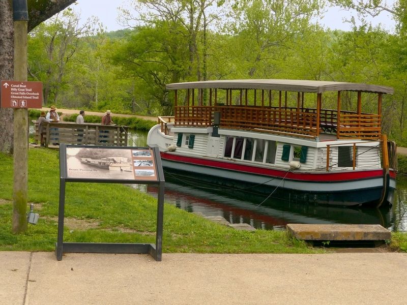
In days past, while standing on the edge of the canal one would see a variety of boats float by. During the peak operating years of the C&O canal in the 1870's, as many as 550 freight boats were in use on the canal carrying tons of coal from . . . — — Map (db m103042) HM
“It is a refuge, a place of retreat, a long stretch of quiet and peace at the Capital …”William O. Douglas.
Look around you. The park you stand in exists because people cared. In January 1954, Justice William O. Douglas of . . . — — Map (db m49848) HM
The C&O Canal was built within the Potomac river floodplain and floods routinely threatened the canal and towpath. Stop gates were erected at particularly vulnerable locations to deflect the destructive waters. A stop gate consisted of sunken stone . . . — — Map (db m164459)
One of the most picturesque spots in Maryland.
George Washington came here many times and built canal locks on the Virginia side to make the river navigable for his "Potomac Company." — — Map (db m70177) HM
Life was very different around the Great Falls Tavern during the canal era. The building before you began as a small lockhouse and was added onto twice until it became what you see today. The area around the tavern bustled with a community of over . . . — — Map (db m71604) HM
Built between 1826 and 1831
by the
C & O Canal Company.
The tavern provided meals
and lodging for
canal travelers and boatmen
for nearly a century.
— — Map (db m160740) HM
If walls could talk then Lockhouse 22 could tell some tales. One might hear about President Grover Cleveland who sought refuge from the pressures of the White House by coming here on fishing trips. Or perhaps the lockhouse would tell of one . . . — — Map (db m28302) HM
Human habitation in the Potomac River Basin has existed for 9,000 years, according to archeological evidence. The name "Potomac" derives from the Algonquian word "patawomeke," which means "trading place." The first English settlement, St. Mary's . . . — — Map (db m61574) HM
A 125-foot towpath breach opened just upstream from this site in September 2008 as a result of Tropical Storm Hannah.
The C&O Canal Trust, the Park's official nonprofit partner, raised $100,000 from private sources, which was used for site . . . — — Map (db m160741) HM
The C&O Canal Company encountered many obstacles in creating a water highway highway that connected the Potomac and Ohio rivers. Navigating around the Great Falls proved one of the most challenging. Here, where the Potomac River plunges more than 41 . . . — — Map (db m152575) HM
Has a job ever rewarded you with more than a paycheck? This was the case for many young African-American men who reported for duty each morning at Camp NP-2, where you are now standing. They lived a military lifestyle as Civilian . . . — — Map (db m160754) HM
Have you ever had difficulty finding a job? During the Great Depression of the 1930s, 15 million Americans—a quarter of the nation's workforce—were unemployed. Many people lived in poverty. African-American unemployment rates were two to three . . . — — Map (db m160747) HM
When a river, such as the Potomac, was too swift or shallow for navigation, shippers built canals with lift locks along the river course. The C & O Canal consists of flat stretches of water connected by lift locks. The use of locks enabled the . . . — — Map (db m194061) HM
In 1823, the deacons of the Bethel Baptist Church acquired a half-acre lot at this site to erect a church and provide a burial ground. The original church was replaced in 1864, but a half century later, the congregation demolished it and built a . . . — — Map (db m174803) HM
On June 24, 1863, Gen. J.E.B. Stuart, leaving 3,000 cavalrymen in Rectortown, Virginia, to monitor Federal activity, led three Confederate cavalry brigades to Haymarket. Encountering Union Gen. Winfield S. Hancock’s corps marching north, Stuart sent . . . — — Map (db m201496) HM
Eleven aqueducts were built from Georgetown to Cumberland to carry water over water. The aqueducts, literally “water bridges,” carried the canal over large streams and rivers flowing into the Potomac River. This aqueduct enters directly into the . . . — — Map (db m96115) HM
Sitting near the junction of the Potomac River and the Great Seneca Creek, the Seneca Mill had a long tradition at this pivotal location.
By 1725, a grist mill functioned here as a commercial staple for the small village. Early proprietors . . . — — Map (db m96104) HM
Canal engineers build aqueducts to bridge canal boats over rivers and large stream such as Seneca Creek. Eleven aqueducts were needed between here and the canal’s western terminus at Cumberland, Maryland; all required skilled quarrymen and . . . — — Map (db m760) HM
Why are there two locks here? While they may look similar, the two locks played very different roles in the operation of the canal. The lock in front of you is Inlet Lock 2. The lock behind you is Lift Lock 23. Lift locks raised and lowered boats to . . . — — Map (db m22039) HM
The Establishment of Silver Spring's first bank and Newspaper, traditional institutions required for a community to grow and prosper, occurred on this corner with the opening of the Silver Spring National Bank in 1910 and publication of The . . . — — Map (db m62165) HM
“…A Full Line of Dry Goods and Clothing” was available at Moses Sclar's Grand Leader Store (8221 Georgia Avenue), which opened in 1926 and adjoined John and Joseph Dolan's project (see opposite side) to the south. In operation for over a . . . — — Map (db m79236) HM
Silver Spring's First Movie Theater, the 500-seat SECO (Suburban Electric Company), which opened on November 7, 1927 with the silent film "Fireman Save My Child," was located at 8242-8244 Georgia Avenue. The theater, renamed Roth's Silver . . . — — Map (db m125279) HM
At three stories, this was Silver Springs tallest building. Occupying the prime corner lot at 8435 Georgia Avenue was the Masonic Temple, home of the Silver Spring Lodge No. 215 A.F. & A.M. of Maryland. (Ancient and Free Accepted Mason). About three . . . — — Map (db m62102) HM
Built by the Maryland colony in 1756 during the French and Indian War, Fort Frederick’s stone walls surrounded three large buildings. The colonists abandoned the frontier fort in 1759, when the threat of Indian raids subsided. During the . . . — — Map (db m821) HM
Here the Potomac River makes a meandering four-mile loop around Prather’s Neck. To avoid the bend in the river, the canal engineers cut the canal one-half mile across the neck. Because of the rapid elevation change, these four locks were . . . — — Map (db m15285) HM
“Here at Four Locks mule barn, mules rested during the winter months. Boat captains left their mules here, paying a mule tended to care for them. Often the mules grew thin because the keeper did not feed the mules as well as their owners . . . — — Map (db m15278) HM
Four Locks – locks 47 through 50 – were built between 1836 and 1838, all within a half-mile stretch of the canal. Nestled amongst these four locks, a close-knit community thrived while the canal was in operation. Businesses prospered, meeting the . . . — — Map (db m36716) HM
Floods occur at regular intervals in the Potomac Valley. Between 1829 and 1998 there have been 144 recorded floods or high water occurrences. repairing flood damage was a continuing battle for the C&O Canal Company and is still a problem for the . . . — — Map (db m25142) HM
At the outbreak of the Civil War, Maryland became a border between the Confederacy and the Union. The Confederacy knew that the canal and railroad were important Union supply lines. Stonewall Jackson’s Brigade made several attempts to destroy Dam 5 . . . — — Map (db m23561) HM
This was a lively Unionist community on the important National Road during the war. In nearby Four Locks on January 31, 1861, local residents raised a 113-foot-high “Union Pole” with a streamer proclaiming the “Union Forever.”
Many local men . . . — — Map (db m60553) HM
"In October 1877, Bench Mark "A" was cut on the water table of the recently rebuilt courthouse in Hagerstown, Maryland", reads the report of the coast and geodetic survey to President McKinley. This was the beginning point of a . . . — — Map (db m6529) HM
"This sculpture is very significant to me. It depicts the importance of transportation to the history of my home county. It is made all the more special because it is installed outside my library in Hagerstown, the place where I dreamed and was . . . — — Map (db m114375) HM
A panorama of the original Maryland-West Virginia river bridge. Foreground on right the Western Maryland Railroad station. Mid photo - the toll house for the bridge and the toll keeper's house with the C&O Canal and tow path to the right. . . . — — Map (db m199822) HM
Looking at the remaining iron railings and graceful arch of the Tonoloway Aqueduct, it is easy to see why canal company officials referred to the eleven aqueducts along the canal as “works of art.” Built between 1835 and 1839, Aqueduct 7 . . . — — Map (db m61165) HM
1. Big Pool Junction
The Big Pool Train Station was constructed in 1892 to make a connection with the B&O Railroad across the river at Cherry Run, WV. The Western Maryland Railroad was in a boom stage of growth with the 18 miles of rail . . . — — Map (db m96131) HM
Situated on the Potomac River at the narrowest point in the state of Maryland the town of Hancock is rich in history. The town is named for Joseph Hancock, Jr., who ferried travelers, traders, and commerce across the Potomac.
In 1818, the . . . — — Map (db m96126) HM
Construction of the C&O Canal was completed through Hancock by the late 1830s. The network between the coal mines, dealers, merchants, canal company, and tidewater shipping became economically strong.
As a result of the increasing prosperity in . . . — — Map (db m96128) HM
Across the canal bed are the remains of the once prosperous Round Top Cement Mill. The abundance of high calcium limestone drew cement manufacturers to this area in 1838. A useful material, limestone can be cut into building blocks or burned and . . . — — Map (db m96123) HM
The layers of red sandstone, siltstone, shale and limestone beneath the limekilns on the other side of the canal are like pages in a book to geologists. These folded, even rock layers indicate that millions of years ago this area was covered by a . . . — — Map (db m96125) HM
Before you, at the top of Church Street, stands St. Thomas Episcopal Church, which became an unintended target of Gen. Thomas J. “Stonewall” Jackson’s artillery on January 5-6, 1862. Jackson had led his force from Winchester, Virginia to destroy as . . . — — Map (db m832) HM
The Chesapeake and Ohio Canal was a crucial strand in an economic web stretching from the mountain town of Cumberland to the tidewater ports of Georgetown and Alexandria.
The canal depended on the prosperity of the nearby towns, businesses and . . . — — Map (db m96127) HM
Built in the 1780’s this farm house witnessed the arrival of the C&O Canal in the mid-1830’s. Located at the east side of Hancock, the house residents catered to canawlers who passed through Lock 52 and the Tonoloway Aqueduct, selling goods and . . . — — Map (db m61164) HM
Lock 34 was often referred to as "Goodheart's Lock". Willard Goodheart was the last locktender at this location. Like nearby Lockhouse 33, the lockhouse at Lock 34 was destroyed in the great flood of 1936. Of the 1936 flood, Mr. Goodheart as quoted . . . — — Map (db m23872) HM
Here, the forces of nature created a natural corridor for commerce. The Shenandoah and Potomac Rivers carved a notch in the mountains, providing passage west. Communities grew up on both sides of the river and later a turnpike, railroad, and canal . . . — — Map (db m4978) HM
This Civil War era photograph offers a glimpse into the two Shepherdstown communities that grew up along the river. The stone pilings in this photograph were all that remained of the covered bridge burned by Confederate troops led by Stonewall . . . — — Map (db m60705) HM
The brick home in front of you (Picture included) once stood at the heart of a Western Maryland plantation called "Ferry Hill." Built between 1812 and 1820, the plantation consisted of nearly 700 acres of land, a tavern, and a ferry. An enslaved . . . — — Map (db m58252) HM
John Blackford, in 1810, built the Ferry Hill Plantation House standing before you. Blackford owned 25 slaves and managed the farm by himself. The slaves and hired laborers worked with minimum direction. Two slaves, Ned and Jupe, ran the river ferry . . . — — Map (db m1971) HM
A day after the Battle of Antietam, Confederate General Robert E. Lee retreated to the safety of the West Virginia (then Virginia) bluffs across the river from here. This was the only good crossing on the river for many miles upstream or downstream. . . . — — Map (db m154202) HM
History passed through the town of Shepherdstown for centuries. Native Americans cross the Potowomack River at the ford below the bluffs. German settlers crossed at Packhorse Ford as they emigrated from Pennsylvania into Virginia's Shenandoah . . . — — Map (db m60706) HM
It shall be their duty, at all hours, by night as well as by day, to pass all boats and floats presenting themselves at their locks.
Charles Mercer, President, C&O Canal Company
On September 10, 1862, Gen. Robert E. Lee ordered Gen. Thomas J. “Stonewall” Jackson and a detachment of 15,000 men, about two-thirds of the Army of Northern Virginia, to capture the Union garrison at Harpers Ferry and secure Confederate . . . — — Map (db m1118) HM
Eleven aqueducts were built from Georgetown to Cumberland to carry water over water. The aqueducts, literally “water bridges,” carried the canal over the large streams and rivers flowing into the Potomac River.
The Conococheague Creek . . . — — Map (db m60571) HM
It is a refuge, a place of retreat, a long stretch of quiet and peace at the Capital’s back door…William O. Douglas.
Look around you. The park you stand in exists because people cared. In January 1954, Justice William O. Douglas of the Supreme . . . — — Map (db m60585) HM
Home of Brig. Gen. Otho Holland Williams, Revolutionary War hero and founder, 1786, of Williamsport, and of Col. Elie Williams, president of commission to lay out National Road and chief surveyor Chesapeake and Ohio Canal. President George . . . — — Map (db m3909) HM
William’s Port lay on the edge of the Maryland frontier in 1787 when founded by Revolutionary War hero General Otho Holland Williams. In 1790 this river town nearly became capital of the United States when President George Washington personally . . . — — Map (db m60583) HM
Senior Chief Engineer
of the New York Canals
His public history may be found
in the history of the General
and State Goverments;
His private [virtues?] in the memory
of his acquaintances
Born in Pennsylvania
July 22, 1763. . . . — — Map (db m181134) HM
Buried beneath this canal stone lies Lock #3 of the Alexandria Canal, which connected the Harbor of Alexandria with the Chesapeake and Ohio Canal in Georgetown, D.C. between 1843 and 1886. After Crossing the Potomac on an aqueduct bridge near the . . . — — Map (db m80668) HM
The Alexandria Canal officially opened on December 2, 1843. The seven-mile long canal extended from the Chesapeake and Ohio Canal in Georgetown to Alexandria's ports on the Potomac River. Boats brought coal, limestone, iron ore, port and . . . — — Map (db m147123) HM
These stones are remnants of Lock #4 of the Alexandria Canal which once occupied this site. Completed in 1843, the canal linked the Alexandria waterfront with the C & O Canal in Georgetown. — — Map (db m131390) HM
Rosslyn traditionally has served as a principal gateway to Arlington and to Virginia. Captain John Smith explored this area in 1608. Awbrey's Ferry carried travelers across the Potomac for more than a century in the 1700s and 1800s. The Aqueduct . . . — — Map (db m82493) HM
Fort C.F. Smith was constructed in early 1863 as part of the expansion and strengthening of the capital’s defenses that continued throughout the Civil War. With Forts Strong, Morton and Woodbury, Fort C.F. Smith formed the outer perimeter of the . . . — — Map (db m5099) HM
Fort C.F. Smith was constructed in 1863 on farmland appropriated from William Jewell. The fort was named in honor of Gen. Charles Ferguson Smith, who was instrumental in the Union victory at Fort Donelson, Tennessee in 1862. The fortification was . . . — — Map (db m5101) HM
Fort C.F. Smith was constructed early in 1863 as part of the expansion and strengthening of the capital's defenses that continued throughout the war. With Forts Strong, Morton, and Woodbury, Fort C.F. Smith formed the outer perimeter of . . . — — Map (db m175254) HM
Fort C.F. Smith was constructed in 1863 on farmland appropriated from William Jewell. The fort was named in honor of Gen. Charles F. Smith, who was instrumental in the Union victory at Fort Donelson, Tennessee, in 1862. Fort Smith extended the . . . — — Map (db m175256) HM
Wheat farming and flour milling were the backbone of the Clarke County economy for more than 150 years. Throughout those years, we were home to at least 60 mills and tiny Clarke County contributed mightily to the Shenandoah Valley's . . . — — Map (db m172247) HM
This riverfront park will transport you back in time. It will enable you to look beyond the modern developments that dominate the landscape here today. It will take you back centuries, when American Indians lived here, harvesting the bounty of the . . . — — Map (db m152026) HM
1. Sugarloaf Mountain - This was the site of a Union Signal Corps station that remained in operation throughout much of the war. 2. White's Ferry - Originally called Conrad's Ferry, this crossing was established in 1817 about four miles . . . — — Map (db m27839) HM
After Confederate Gen. Robert E. Lee's stunning victory at Chancellorsville in May 1863, he led the Army of Northern Virginia west to the Shenandoah Valley, then north through central Maryland and across the Mason-Dixon Line into . . . — — Map (db m63737) HM
Beginning in the 1730s, Waterford's residents developed productive farms, a series of mills, and a transportation network. By the early 1800s, Thomas Phillips, an enterprising Quaker, farmed the land in front of you.
To ensure access to the . . . — — Map (db m143137) HM
Welcome to Government Island. This 17-acre historic site is an early American quarry originally named Brent’s Island or Wiggington’s Island. As early as 1694, stone was quarried from this site for use as architectural trim in Colonial America. . . . — — Map (db m39550) HM
Romney experienced many troop movements and skirmishes during the course of the war because of its location on the vitally important North Western Turnpike. The road linked Winchester, near the northern end of Virginia’s Shenandoah Valley, with . . . — — Map (db m159293) HM
Enjoy over 3,000 acres of rivers, trails, and battlefields in historic Harpers Ferry
Near the Visitor Center: Battlefields and Trails
Experience Harpers Ferry's tumultuous past. Pick up park trail maps and guides at the visitor . . . — — Map (db m143936) HM
The Federal offensive in the Shenandoah Valley begun in May 1864 faltered in the summer with Confederate victories and Gen. Jubal A. Early's Washington Raid in July. Union General Philip H. Sheridan took command in August, defeated Early . . . — — Map (db m238786) HM
In 1806, workmen with hand tools widened and deepened this channel for cargo boats to bypass, or "skirt," the rapids in the Shenandoah River. Linked with many other skirting canals" en route to Washington, D.C., this passage became part of the . . . — — Map (db m18988) HM
Construction of the Chesapeake and Ohio Canal and the Baltimore and Ohio Railroad produced an influx of Irish laborers into the Harpers Ferry area during the early 1830's. St. Peter's Catholic Church, completed in 1833, symbolizes America's melting . . . — — Map (db m18789) HM
Water from the canal flowed through underground tunnels, turning water wheels and powering armory machinery before it exited through tailraces. — — Map (db m143943) HM
Work on the railroad and canal progressed slowly at first, but by 1834 both companies had completed construction to a point opposite Harpers Ferry. The canal had won the race to this point and it continued up the Maryland side of the Potomac. . . . — — Map (db m12062) HM
As the railroad streaked westward from Harpers Ferry, the C&O Canal fell hopelessly behind in the race for Ohio. Burdened by a lack of building supplies and a scarcity of skilled labor, the canal encountered serious financial problems and did not . . . — — Map (db m12064) HM
Rail transportation in the United States began in Baltimore, Maryland on July 4, 1828, when Charles Carroll, the only living signer of the Declaration of Independence, laid the cornerstone of the Baltimore and Ohio Railroad.
On the same day . . . — — Map (db m12060) HM
Shepherdstown was established near a natural ford used by American Indians and early settlers to cross the Potomac River. A ferry service, begun in 1775, reliably connected Shepherdstown with communities throughout Maryland and Pennsylvania for . . . — — Map (db m154072) HM
Shepherdstown, the oldest town in what is now West Virginia was incorporated as Mecklenburg in 1762, but was renamed Shepherd's Town in 1798 in honor of its founder Thomas Shepherd. From the French and Indian War to the Civil War the town has been . . . — — Map (db m143927) HM
An inspection of tobacco shall be…established on the lands of the said Abraham Shepherd to be called and known by the name of Mecklenburg warehouse.
– Act of the Virginia Assembly, passed November 29, 1788.
Beautiful panorama of West Virginia, Pennsylvania, and Maryland. It overlooks the Chesapeake and Ohio Canal which was started by George Washington and associates in order to improve communication with the west. — — Map (db m97341) HM
On January 1, 1862, Confederate Gen. Thomas J. "Stonewall" Jackson led four brigades west from Winchester, Va., to secure Romney in the fertile South Branch Valley on the North Western Turnpike. He attacked and occupied Bath on January 4 . . . — — Map (db m159462) HM
Today's View Panorama Overlook marks the north end of Cacapon Mountain's 30-mile march. Composed of Oriskany sandstone, it plunges nearly 1000 feet into the Potomac River, which bends along the base of the Overlook as it heads downstream . . . — — Map (db m167603) HM
185 entries matched your criteria. Entries 101 through 185 are listed above. ⊲ Previous 100