519 entries match your criteria. The first 100 are listed. Next 100 ⊳
Civilian Conservation Corps (CCC) Historical Markers
Markers relating to the Great Depression-era New Deal federal work relief program that operated from 1933 to 1942 in the United States for unemployed, unmarried young men from relief families.
By Mark Hilton, June 16, 2021
CCC Bunker Observation Tower Marker in foreground.
I propose to create a Civilian Conservation Corps to be used in simple work...More important however, than the material gains will be the moral and spiritual value of such work.
–Franklin D. Roosevelt
Cheaha State Park was built by the . . . — — Map (db m175327) HM
On Oct. 29, 1929 the world changed as we know it. On that
ominous day, the stock market crashed and facilitated the U.S.
Great Depression. Many Americans were unemployed and
numerous families lost their homes to foreclosure. In 1933
President . . . — — Map (db m175325) HM
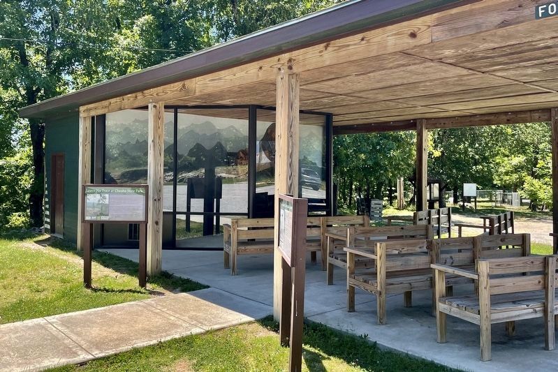
In 1933 the Civilian Conservation Corps began construction of Cheaha State
Park as parks across the nation were built, President Franklin D. Roosevelt
provided jobs and stability as well as parks for future generations. The 2,799
acre Cheaha . . . — — Map (db m175560) HM
Near River Bank Road, on the right when traveling south.
The Civilian Conservation Corps was born during the turmoil of the Great Depression. Hundreds of thousands of young men were out of work, and wasteful exploitation of the environment had devoured millions of acres across America. In 1933, as part of . . . — — Map (db m144813) HM
On Murphy Drive, 0.2 miles east of Wrights Mill Road (County Road 33), on the right when traveling east.
Side 1
Under President Franklin D. Roosevelt's New Deal (1933-1942), the Civilian Conservation Corps (CCC) was established to provide work for single young men. The CCC's Company 4448, Camp Alabama SP-12, began work in September 1935 to . . . — — Map (db m85164) HM
On Monte Sano Blvd Southeast at Highland Plaza Southeast, on the right when traveling north on Monte Sano Blvd Southeast.
This rock entrance is all that remains of Camp Ala. SP-16, 3486 and Camp Ala. TVA-7, 3483 which were built here due to available water. They were part of President Franklin D. Roosevelt's conservation projects. When WW II started the men enlisted . . . — — Map (db m55607) HM
On Main Street at West 4th Street, on the left when traveling north on Main Street.
Natives of Southeast Alaska have made totem poles such as this one for thousands of years.
This pole depicts four Haida clan stories. It was carved in 1940 by master carver John Wallace of Hydaburg. Described as "the last of the professional . . . — — Map (db m181736) HM
On Calhoun Avenue north of West 4th Street, on the left when traveling north.
Built by the Civilian Conservation Corps — 1935
Olaf Torkelson, Juneau Street Commissioner from 1924-1936, was instrumental in the success of this project. The overpass was built to provide safe access for children who attended Capital School . . . — — Map (db m181738) HM
Trans-Canyon Telephone Line,
built in 1935 by CCC workers,
maintained by Mountain Bell,
has been placed on the
National Register of
Historic Places
by the United States
Department of the Interior. — — Map (db m78832) HM
On West Bill Williams Avenue/West Route 66 at South 2nd Street, on the right when traveling east on West Bill Williams Avenue/West Route 66.
Has been placed on the National Register
of Historic Places by the United States
Department of the Interior
Cormick E. Boyce built this large brick structure intending it to be used as a bank, although it served as a grocery store during . . . — — Map (db m33417) HM
Lemmon Rock Lookout Tower was erected in 1928. It is the oldest lookout still in use on the Forest. This general locale has been used as a fire lookout since the Coronado Forest Reserve was established in 1902. The current lookout structure was . . . — — Map (db m55554) HM
Honoring the young men who served in the Civilian Conservation Corps here and across the nation. With shovel and hammer, trowel and chisel, they moved earth, planted trees, crafted stone, and built structures that shape our landscape and remain a . . . — — Map (db m30614) HM
On Petit Jean Mountain Road, on the left when traveling west.
This statue honors Civilian Conservation Corps
Company V-1781. these skilled veterans of World War
One built Arkansas's first state park. — — Map (db m233674) HM WM
Davies Bridge, a sturdy Rustic-style structure, stands today as an emblem of the park's Civilian
Conservation Corps (CCC) heritage and the Davies family's contributions to Arkansas State Parks.
In 1932, Samuel G. Davies, a graduate of . . . — — Map (db m233672) HM
As you explore these unique structures around Petit Jean State Park,
you will find that nature and history are strongly connected here.
Rock House Cave - Explore this sandstone
bluff shelter and look for ancient Native
American . . . — — Map (db m233679) HM
Company V-1781 was the
designation of Petit Jean's CCC.
camp. The "V" indicated the
company employed World War I
veterans. The situation was
relatively unique: only 10 percent
of CCC camps around the United
States were veteran camps. . . . — — Map (db m233675) HM
Following the stock market
crash of 1929, the United States
plunged into the depths of the
Great Depression. By 1932, the
unemployment rate was a
staggering 23%. Over 13 million
Americans had lost their jobs.
In a landslide victory, . . . — — Map (db m233673) HM
Near Arkansas Route 168, 0.6 miles north of Arkansas Route 141, on the right when traveling north.
Crowley's Ridge State Park is here today due to the hard work, dedication, and
ingenuity of the local community and the Civilian Conservation Corps.
Crowley's Ridge State Park is home to log and stone structures
built by the Civilian . . . — — Map (db m170555) HM
On Arkansas Route 168, 0.6 miles north of Arkansas Route 141, on the right when traveling north.
Crowley's Ridge State Park is here today due to the hard work, dedication, and ingenuity of the local community and the Civilian Conservation Corps.
Roosevelt's Tree Army
The men of Civilian Conservation Corps (CCC) companies
1729, 2736, . . . — — Map (db m170556) HM
Near Arkansas Route 155, 0.2 miles north of County Road 92, on the right when traveling north.
With its rugged, scenic beauty and views of the Arkansas River Valley, Mount Nebo has been a popular recreational destination since the late 19th century. In 1928, the 1,350-foot landmark became Arkansas’s second state park. On April 5, 1933, . . . — — Map (db m206938) HM
The large outcrop with the staircase and cables is Sentinel Rock. The Civilian Conservation Corps (CCC) installed the steps and railings on Sentinel Rock sometime berween 1933 and 1942. It is now a popular climbing rock.
One of the responses of . . . — — Map (db m199523) HM
A large flashing light atop this rotunda once guided airplanes flying through the night skies of the Bay Area. Originally held aloft on a 75-foot tower erected by Standard Oil in 1928, it served as a crucial route-finding aid in the days before . . . — — Map (db m93631) HM
Like many other isolated peaks, Mt. Diablo is steeped in lore - much of it involving the mountain's name.
On a 1824 map, "M. del Diablo" signifies a Christian Indian village, not a peak. The reference to "diablo" or devil can be traced back to . . . — — Map (db m93632) HM
Near Newton B. Drury Scenic Parkway, 1.1 miles north of Redwood Highway (U.S. 101), on the left when traveling north.
Company 1903 Comes to the Prairie In October 1933, CCC Company 1903 moved from Hyampom, in Trinity County, to Prairie Creek. Along with the 113 enrollees were seven soldiers — three officers, three sergeants, and a cook — who would . . . — — Map (db m159100) HM
On California Route 190, 0.2 miles east of Emigrant Canyon Road, on the right when traveling east.
Among the first structures greeting visitors entering
the park from the west, these two stone buildings at
Emigrant were built to serve as a ranger station and
are a legacy of the Civilian Conservation Corps
(CCC). Created by President Franklin . . . — — Map (db m159295) HM
On Charcoal Kiln Road, 0.4 miles east of Emigrant Canyon Road, on the right when traveling east.
During the 1930s, Americans struggled with the financial and social turmoil of the Great Depression. The employment rate reached 25 percent, and many men were unable to support their families. Their frustration contributed to the election of . . . — — Map (db m159360) HM
Near Zoo Drive, 0.1 miles east of Forest Lawn Drive.
The CCC had two camps in Griffith Park. Camp Griffith Park, originally located just east of this site, was occupied from May 1934 to May 1936. A statue honoring the CCC was sculpted by John Palo-Kangas as a WPA Federal Art Project and placed in that . . . — — Map (db m137298) HM
On McKinley Avenue, 0.5 miles east of Fairplex Drive.
Julius Caesar's reign over Rome was
approaching its dramatic end (44 BCE),
when this giant sequoia sprouted - the
tree providing this magnificent round.
Until felled in Tulare County by a windstorm
in 1961, this massive tree, nicknamed . . . — — Map (db m218620) HM
On Pacific Coast Highway at Park Lantern, on the right when traveling east on Pacific Coast Highway.
Doheny State Beach was once known as Doheny Beach State
Park (1931). These pictures depict the early years at Doheny, 1934-1938, when much of the work done in the park was performed by
the Civilian Conservation Corps. or CCC. The CCC enrollees . . . — — Map (db m193592) HM
Logging was one of the most significant
impacts on the natural landscape on the
western side of the San Jacinto Mountains.
Beginning in 1875 and lasting through the early 1900s,
a number of logging camps and mills were established
in the . . . — — Map (db m232790) HM
Near Mill Creek Road, 0.1 miles east of Bryant Street, on the right when traveling east.
Commemorating enrollees, CCC Co’s. 541, 1341, 1941, 1943, and Forest Service - Military - Civilian personnel, CCC Camp Mill Creek F150, FD150.
This plaque acknowledges the many
accomplishments of all concerned.
History . . . — — Map (db m197571) HM
Near Arrowhead Avenue, on the left when traveling south.
Honoring Pres. Franklin D. Roosevelt who established the Civilian Conservation Corps 1933-1942.
Commemorating CCC enrollees and all who were in the CCC camps in San Bernardino County. — — Map (db m172178) HM
On March 31, 1933, President Franklin D. Roosevelt signed into law an act creating the Emergency Conservation Work Program, better known as the Civilian Conservation Corps (CCC). This program became one of the most popular and successful of . . . — — Map (db m192107) HM
Across this bridge lies California's eleventh mission and a glimpse of life during the 1820's. The Civilian Conservation Corps restored the buildings and grounds between 1934 - 1941. We hope you enjoy your visit to the past. — — Map (db m11116) HM
At New Almaden
During the Depression (1933-1942) and after most mining activity had ceased, New Almaden once again gave jobs, hope and future to young men through a program created by Franklin D. Roosevelt called the Civilian . . . — — Map (db m52778) HM
[Side-bar on left:]
Once a Bustling
Community
Within view stood English Cam’s Methodist Church, Company Store, Mine Office, School House, Centennial Hall, Helping Hand Hall and a multitude of family cabins. As quicksilver . . . — — Map (db m52775) HM
The Civilian Conservation Corps, established in 1933 by the Federal Government for nine years became one of the most constructive national service programs. CCC Companies: 1917-V, 1235, 3341, 3325, 739, 4500 occupied this camp between 1933 and 1939. . . . — — Map (db m52774) HM
Near Lake Road north of California Highway 89 S, on the right.
The Civilian Conservation Corps (CCC) was established in 1933 under President Franklin D. Roosevelt’s New Deal program.
During the years of the Great Depression, when the stock market crash and ensuing business closures left many Americans . . . — — Map (db m96652) HM
For just six short years Sims was the location of a bustling Civilian Conservation Corps (CCC) camp...
With its wooded valley and beautiful river setting, Sims was a haven to the boys from Company 978 who came from the busy cities of San . . . — — Map (db m69843) HM
It took a bit of grit and determination for the Forest Service and Civilian Conservation Corps (CCC) crew to build this sturdy bridge...
Raymond Huber, who supervised the project remembers... “I was given a pickup and a plan of a 160-foot . . . — — Map (db m69821) HM
On Lassen Peak Highway (Scenic California Route 89) 13 miles north of California Route 36, on the right when traveling north.
Today we take this park road for granted, but in 1916 when Lassen Volcanic National Park was established, the park's scenic features, expansive views, and volcanic landscapes could be reached only by horseback or on foot. In 1925, through the vision . . . — — Map (db m165932) HM
On California Route 44 at Lassen Peak Highway (California Route 89), on the right when traveling north on State Route 44.
This stone monument, built in 1935, stands at the historic north entrance to Lassen Volcanic National Park from Lassen National Forest. Before the highway intersection was rerouted to its current location, visitors drove past this monument into the . . . — — Map (db m58126) HM
President Franklin Delano Roosevelt established the Civilian Conservation Corps on March 31, 1933, to provide employment for America's youth and promote the nation's economic recovery. The CCC's work involved conservation projects on forest, park . . . — — Map (db m547) HM
“When I was a child…I played around Tule Lake where the tules and grass grow thick… We used to go out in the tall grass… and look for chub fish… and shoot at (them) with our arrows.”
Peter Schonchin, last surviving . . . — — Map (db m63249) HM
On Hill Road near East West Rod, on the left when traveling north.
1935-1942
Civilian Conservation Corps
This camp was built and staffed by the CCC, an organization that was established during the Great Depression by President Franklin Roosevelt to reduce unemployment and to preserve the nation's . . . — — Map (db m88000) HM
On Crescent Meadow Road, 1.7 miles south of Generals Hwy, on the left when traveling south.
Shaping a Park
The CCC Boys
Tunnel Log reminds us of the work of young men who struggled to survive the Great Depression in the 1930s. The drive-through hole in the log was carved by the “boys” of the Civilian Conservation Corps . . . — — Map (db m103433) HM
Near Tioga Road (California Route 120), on the right when traveling east.
The CCC began work in Yosemite in May 1933. During the ensuing years, significant projects included the Half Dome cable system, Badger Pass Ski Complex, Henness Ridge Lookout Tower, numerous park structures and many miles of hiking and riding . . . — — Map (db m155198) HM
On Colorado Street (County Route 86), on the right when traveling west.
Trail Under Siege Indians of Colorado’s High Plains
Kiowa and Comanche Indians migrated to these prairies in the 1700s, followed by Cheyennes and Arapahos in the early 1800s. The region’s vast grasslands, thick bison herds, and brisk fur . . . — — Map (db m45756) HM
On 8th Street east of Grand Avenue, on the right when traveling east.
In the 1930's, America was mired in a deep economic depression. As part of his New Deal program, President Franklin Roosevelt implemented government programs designed to create employment and to stabilize the national economy.
One . . . — — Map (db m120550) HM
Principle construction by Civilian Conservation Corps Company 1848, SP-13C, Mt. Morrison, CO.
1936 - 1941
Dedicated as a memorial to all who served at Mt. Morrison and to the 3 million who served in the CCC nation-wide, 1933 - 1942. The CCC . . . — — Map (db m57683) HM
Red Rocks Park is a national Historic District on the National Register of Historic Places. The Trading Post and the Amphitheater are Denver Landmarks. The Trading Post, an example of the Pueblo-style architecture, is made of brick and stucco and . . . — — Map (db m57641) HM
On Fall River Road (U.S. 34) 0.2 miles north of Trail Ridge Road (U.S. 36), on the left when traveling south.
Little Horseshoe Park was the site of the first Civilian Conservation Corps (CCC) camp west of the Mississippi River. In May 1933, CCC workers set up a base in the meadow below to house about 200 men.
This camp’s laborers became known as the . . . — — Map (db m162063) HM
The first people to witness this view were probably Indians who had to scale the steep cliffs and talus slopes. Later, ranchers dug narrow passages up into the canyons to bring their cattle to graze in the rich highland trails below.
Begun during . . . — — Map (db m61910) HM
On West River Road, 1.5 miles north of Route 318, on the right when traveling north.
In this Area in the Past.....
The Austin Hawes Memorial Campground is located in an area once known as the “Greenwoods,” where until the late 1700’s large pine and hemlock trees grew along the Farmington River. From 1800 to 1942 . . . — — Map (db m102111) HM
On Legion Road, 0.1 miles south of West River Road, on the right when traveling south.
To honor the men of
Camp White
Company 106
established 1934
Civilian Conservation Corps
1933-1942
created by
President Franklin D. Roosevelt
renewing the country’s natural resources
and challenging the human spirit
of . . . — — Map (db m102082) HM
On Kent Cornwall Road (U.S. 7) 0.4 miles north of Carter Road, on the right when traveling north.
To Honor The Men Of
Camp Macedonia
Company 1191
Established 1935
Civilian Conservation Corps
1933-1942
Created By
President Franklin D. Roosevelt
Renewing The Country's Natural Resources
And Challenging The Human Spirit
Of A . . . — — Map (db m41092) HM
Near Burr Mountain Road, 0.2 miles north of Winsted Road, on the right when traveling south.
To Honor The Men Of
Camp Wolcott
Company 176
Established 1933
Civilian Conservation Corps
1933-1942
Created By
President Franklin D. Roosevelt
Renewing The Country's Natural Resources
And Chellenging The Human Spirit
Of A Nation . . . — — Map (db m30242) HM
On Colchester Avenue (Connecticut Route 16) at Browns Mill Road, on the right when traveling north on Colchester Avenue.
Comstock Covered Bridge
Built in 1873 by the Towns of Colchester and East Hampton
The Comstock Covered Bridge is one of only three historic covered bridges remaining in Connecticut. With a main span 80 feet in length (measured from the faces of . . . — — Map (db m84109) HM
Camp Hadley was home to "Roosevelt's Tree Army." These young men, 17-25 years old, came from families of unemployed parents during the Great Depression. They joined the Civilian Conservation Corps (CCC) and earned one dollar a day, up to 30 days . . . — — Map (db m243157) HM
To provide employment and vocational training for youthful citizens of the United States…through the performance of useful public work in connection with the conservation and development of the natural resources of the United States and its . . . — — Map (db m4491) HM
On South Cannon Street just north of Jacobs Avenue, on the left when traveling north.
John I. "Jack" Lewis (1912-2012) moved to Delaware in 1936 as an artist with the Civilian Conservation Corps tasked with documenting activities at CCC camps in the state. After serving in the Pacific with the U.S. Army during World War II, he . . . — — Map (db m150089) HM
On Gravel Hill Road (State Road 30), on the right when traveling north.
The origin of this congregation can be traced to the organization of “Johnson’s Society” in the 1830’s. Meetings were held in private homes and the local school. On July 3, 1852, trustees were elected to supervise the building of the first church. A . . . — — Map (db m38635) HM
Near Trap Pond Road at Bald Cypress Lane, on the right when traveling east.
From Ironworks to Gristmills
Many of the ponds in this area, including Trap Pond, were created in the late 1700s. The earliest dams were built to produce waterpower for ironworks. The waterpower ran bellows for furnaces that created iron . . . — — Map (db m198864) HM
On Johnson Avenue just east of Dupont Avenue, on the right when traveling east.
Block House Pond, a natural spring-fed pond, has provided fresh water, ice, and recreation to the City of Lewes for several centuries. The pond was likely named for a nearby blockhouse built to protect Lewes in the 1670s, where the town residents . . . — — Map (db m232744) HM
On 13th Street Northwest at Quakenbos Street Northwest, on the right when traveling north on 13th Street Northwest.
Elizabeth Proctor Thomas (1821-1917), a free Black woman whose image appears on each Brightwood Heritage Trail sign, once owned 11 acres in this area. Known, respectfully in her old age as "Aunt Betty," Thomas and her husband James farmed and . . . — — Map (db m72830) HM
On 13th Street Northwest at Quakenbos Street Northwest, on the right when traveling north on 13th Street Northwest.
Civil War Defenses of Washington 1861-1865 The partial reconstruction of Fort Stevens that you see today was done by the Civilian Conservation Corps in 1937. No visible evidence of the original fort remains. Battle of Fort Stevens July . . . — — Map (db m3028) HM
On Swamp Trail just north of Upland Trail, on the right when traveling north.
"The nation behaves well if it treats its natural resources as assets which it must turn over to the next generation increased and not impaired in value."
—Theodore Roosevelt, 1910
As a young man, Theodore Roosevelt realized . . . — — Map (db m213569) HM
On Ohio Drive Southwest south of West Basin Drive Southwest, on the right when traveling north.
Continuing to combat the Great Depression, President Roosevelt's New Deal created federal programs to stabilize the economy, provide relief, and create jobs for millions of Americans. Most Americans had never heard a president's voice before FDR . . . — — Map (db m197631) HM
Near Millhopper Road (NW 53rd Avenue), 0.2 miles east of NW 52nd Terrace, on the left when traveling east.
Devil’s Millhopper
has been designated a
Registered Natural Landmark
This site possesses exceptional value
as an illustration of the Nation’s natural
heritage and contributes to a better
understanding of man’s environment
. . . — — Map (db m125200) HM
(Left side text) During the Great Depression, President Roosevelt approved a plan to recruit thousands of unemployed young men
into a "Civilian Conservation Corps" (CCC)
From 1933-1942 the CCC employed over 3 million Americans. They . . . — — Map (db m55674) HM
This "CCC Boy" Statue
was erected by
Chapter 143, NACCCA,
Gainsville, Florida
In 2007. Chapter 143 was organized by
CCC veterans of the area on
October 1, 1988.
This statue was donated to Chapter 143 and O'Leno
State Park by . . . — — Map (db m66128) HM
2,876,638 American youth
served in 4500 CCC Camps
restoring ravaged lands of a
depressed America.
Some Accomplishments
2 to 3 billion trees planted, 800
parks built, 3980 historical sites
restored, and 6 million days . . . — — Map (db m65804) HM
Near Hammock Road (County Road 634) 1.1 miles west of County Road 635, on the left when traveling west.
Dedicated to the Memory of Emil Billitz Sr. and countless other C.C.C. enrollees who were injured, disabled or lost their lives in performance of their duty. We especially remember the 228 C.C.C. members who perished September 2, 1935 during a . . . — — Map (db m72742) HM
Near State Highway 19, 3.3 miles north of County Road 42, on the left when traveling north.
This structure was built by the Civilian Conservation Corps (CCC) in 1938. It originally served as a home for the State Game Officer for the Ocala National Forest. It has been used by the Forest Service as an office and laboratory. The interior of . . . — — Map (db m167892) HM
On Fort Clinch Road, 3.1 miles north of Atlantic Avenue, on the right when traveling west.
Reconstruction and construction of roads, buildings and grounds was performed by Civilian Conservation Corps
Company 1420, 1937-1942. — — Map (db m33457) HM
On West John Sims Parkway at Evans Street on West John Sims Parkway.
This statue is dedicated to honor the enrollees of CCC Camp Bigby, established May 19, 1933. Company 1402 Forest-3 served from 1933-1939. Company 1413 Army-1 served from 1940-1942. A temporary camp was set up on the grounds of the old Niceville High . . . — — Map (db m192249) HM
On Ocmulgee National Park Road, on the right when traveling east.
The Civilian Conservation Corps (CCC) 1933-1942
Beginning in 1933, hundreds of people were employed at Ocmulgee by the various "New
Deal" public works agencies created during the Great Depression. They worked on the
archeological . . . — — Map (db m244425) HM
On Meddin Avenue near Robinson Avenue, on the left when traveling north.
Activated just prior to the Spanish-American War and inactivated at the close of World War II, Fort Screven served as a military post for almost 50 years. During that time, Fort Screven was a coast artillery installation, an infantry post, District . . . — — Map (db m13076) HM
Near Fort Pulaski Road, on the right when traveling north. Reported missing.
The Confederates used earth and a “blindage” of timbers as protection against shot and shells falling within the fort. To reduce casualties from flying debris, the “light colonnade” or veranda roof along the gorge was . . . — — Map (db m67782) HM
In the 1930s the Great Depression left 25% of the population of the United States unemployed and another 22 million homeless. Newly elected president Franklin D. Roosevelt's "New Deal" programs sought to provide relief and reform to the American . . . — — Map (db m242587) HM
Near Georgia Route 49, 0.5 miles north of Ellaville Street (Georgia Route 228), on the right when traveling north.
After the Civil War, people wanted to preserve Civil War sites and remember fallen soldiers. At Andersonville, the Ladies of the Grand Army of the Republic (LGAR) and the Women's Relief Corps led these efforts. They encouraged states to place . . . — — Map (db m173064) HM
On Hard Labor Creek State Park Road, 0.2 miles east of Knox Chapel Road, on the right when traveling east.
On the occasion of its Bicentennial, Morgan County placed this marker here to commemorate
Hard Labor Creek State Park
This park was built in 1934 by the Civilian Conservation Corps (CCC), a New Deal program sponsored by President . . . — — Map (db m17574) HM
On Fairplay Street, 0 miles north of West Dixie Highway, on the left when traveling north.
On the occasion of its Bicentennial, Morgan County placed this marker here to commemorate the community of
Rutledge
In the 1840s, the heirs of Hezekiah Rutledge deeded right-of-way to the Georgia Railroad. The farm came to be referred . . . — — Map (db m17303) HM
A building to be used as a print shop was constructed by the Kiwanis Club and the citizens of Toccoa on the site later occupied by Ralls Dormitory. The plan for a print shop never developed, so the building was turned into a broom factory. But . . . — — Map (db m64442) HM
Near Spanish Moss Drive (County Route 133) west of U.S. 441 when traveling west.
CCC enrollees completed Little Ocmulgee's Visitor Center in 1936. Called a combination building by the National Park Service for its multiple uses, it is labeled a casino on this early map of the park’s day use area.
Beginning in December 1935, . . . — — Map (db m125199) HM
Near Crater Rim Drive near Mamalahoa Highway (Hawaii Route 11), on the left when traveling west.
The 'Ōhi'a Wing was built by the Civilian Conservation Corps (CCC) in 1932 (sic), and originally served as "Park Headquarters" for Hawaii National Park. Constructed in the classic Rustic Style, it was one of many projects that employed hundreds . . . — — Map (db m111042) HM
The Civilian Conservation Corps (CCC), established by President Franklin Delano Roosevelt in 1933, was one of many "New Deal" Programs created towards economic recovery from the Great Depression. The goal of the CCC was to create Conservation . . . — — Map (db m94340) HM
On Chatcolet Road, 6.5 miles east of U.S. 95, on the right when traveling west.
The Coeur d’Alene people are the earliest inhabitants of this area.
The natural wealth of the forests, rivers, and lakes sustained their existence for countless generations on five million acres of ancestral land.
Their lifestyle was . . . — — Map (db m110383) HM
On Banks Lowman Road (State Highway 17) near Forest Road 555, on the left when traveling west.
(Three panels make up this marker:)
In the 1930s, Gallagher CCC widened and surfaced this road, built Scott Mountain Road, developed Hot Springs and Pine Flat Campgrounds, erected fences to control livestock grazing, fought fires, and . . . — — Map (db m119235) HM
On State Highway 34 near Tincup Road, on the left when traveling west.
Caribou Mountain rises 9,800 feet with alpine snowfields feeding Tincup Creek, a tributary to the South Fork of the Snake River. Placer gold discoveries high on the mountain in 1871 led to a gold rush that lasted for two decades. In the 1880s sheep . . . — — Map (db m105963) HM
On State Highway 75 near Yankee Fork Road, on the left when traveling west.
This 1937 stonework building remains as a tribute to Civilian Conservation Corps (CCC) craftsmanship. CCC workers from Camp Clayton built the structure. It was originally used as a bathhouse and is now a historic site.
The National Forest System . . . — — Map (db m110038) HM
The log Relic Hall is a fine example of Depression Era rustic architecture. Completed in 1937, it also represents a successful early effort to preserve and interpret community history. The building was designed in 1935 by architect Chris Gunderson . . . — — Map (db m44458) HM
Near North Main Street (U.S. 95) near North Dixon Street, on the right when traveling north.
Before you stands the north tower of the original Manning Crevice Bridge. The original bridge was located approximately 14 miles up on the Big Salmon Road. A new bridge was built and opened in 2018.
HISTORY: The Crevice Bridge was first . . . — — Map (db m119429) HM
On Main Street (U.S. 95) near Well Street, on the right when traveling north.
The Riggins irrigation ditch was built in 1891 by early pioneers, Charlie Clay and brothers Isaac and Johnny Irwin, to supply water to their gold mining operation. By 1894, gold mining waned and the ditch was used for irrigation water. It wasn’t . . . — — Map (db m119354) HM
On North 3rd Street (State Highway 55) 0.1 miles south of Lenora Street, on the left when traveling north.
The McCall City Jail was built for $650 in June, 1930, directly behind the City Hall located on the corner of Lenora and Third Streets.
The City Hall building was later moved 12 miles to Roseberry, ID, leaving the jail as a sole reminder of . . . — — Map (db m109934) HM
On West Lake Street (State Highway 55) at State Street, on the right when traveling south on West Lake Street.
Dedicated to the young men
who served in the
Civilian Conservation Corps
from 1933 – 1942.
Their work in the forests and parks in
Idaho remain for all to enjoy
Dedicated August 5, 2006
NACCCA Chapter 28
city of McCall
. . . — — Map (db m110416) HM
Near State Street near Hewitt Street, on the left when traveling south.
A Rich Tradition Of Land Use
Gathering, Hunting, Trapping, Mining, Logging, Ranching, Farming, Recreation
Around 15 thousand years ago, groups of Native Americans started the long history of land use in this area. Today, the Nez . . . — — Map (db m119494) HM
On Lincoln Highway Road (County Road 1520E) just south of County Road 150N, on the right when traveling south.
Left Panel: “This will certify that the foregoing plot of the town of Farmington laid by me as proprietor is correct.
Witness my hand and seal this 30th day of April 1852.”
J. J. . . . — — Map (db m30979) HM
519 entries matched your criteria. The first 100 are listed above. Next 100 ⊳