English settlers built several plantations on the site in the 18th century. The land, much owned by the Swann and Daingerfield families, became part of Alexandria County, D.C. with the creation of the District of Columbia in 1791, and retroceded . . . — — Map (db m115145) HM
Rosemont began as a streetcar suburb just outside the City of Alexandria. It remains an excellent example of this type of early 20th century development. By 1908, investors from Philadelphia; Washington, D.C.; and northern Virginia — operating as . . . — — Map (db m191970) HM
Known as the "Queen of Lynhaven", Ruby Tucker lived not far from this park on Lynhaven Drive for most of her adult life. She was an ardent advocate for her neighborhood and the City of Alexandria.
Ruby Tucker was a caring mother, grandmother . . . — — Map (db m184533) HM
In September 1900, Alexandria County opened the original Mount Vernon School on this property to educate children up to the 8th grade. In spite of continual expansion, crowding was always a problem. By 1932, it was necessary to rent the bank . . . — — Map (db m115682) HM
The Alexandria Gentleman's Driving Club laid out a track just north of here that was operating by 1894, colloquially known as "the St. Asaph Track." In 1897, however, Virginia banned horse race betting, so the track was never as profitable as . . . — — Map (db m115144) HM
The Alexandria Gentleman's Driving Club laid out a track just north of here that was operating by 1894, colloquially known as "the St. Asaph Track." In 1897, however, Virginia banned horse race betting, so the track was never as profitable as . . . — — Map (db m195769) HM
The Alexandria Almshouse was a publicly-funded poorhouse and workhouse where the needy could find refuge and the courts often sentenced people for vagrancy or indebtedness. Residents worked hard for their sustenance. The Almshouse was built about . . . — — Map (db m133930) HM
The Alexandria, Loudoun & Hampshire Railroad was formed in 1847 to carry the agricultural produce of the Shenandoah Valley and western Virginia coal to the port of Alexandria. Financial difficulties, however, meant that the line never got farther . . . — — Map (db m73579) HM
The interurban streetcar caused a revolution in American life, permitting for the first time a suburban lifestyle. "Streetcar suburbs" became the 20th-century ideal of American middle-class family life with a home, yard and commute to work in the . . . — — Map (db m115680) HM
The Town of Potomac
When the Washington, Alexandria & Mount Vernon Railway announced plans in 1892 that included tracks between Washington, D.C. and Alexandria, the flat, open land north of Alexandria became a logical site for a new community. . . . — — Map (db m115147) HM
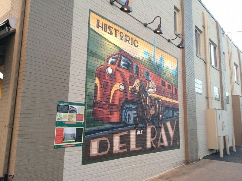
The location of Del Ray Central apartments is often referred to as The Triangle Site. Both the topography of this place and transportation corridors defined the site's shape. The eastern side drops sharply down to the flat plain on which Potomac . . . — — Map (db m115676) HM
In honor of all from the City of Alexandria who served and died during World War I
Robert Adams •
George Anderton •
Stanley Bernard •
Herbert Bernhard •
William Bradley •
Bernard Brock •
William Brown •
Christopher Cloxom • . . . — — Map (db m216132) WM
Potomac Yard was located between Washington D.C. and Alexandria because the site already served as the confluence of many shipping routes; was centrally located on the eastern seaboard; and would alleviate troublesome train congestion from . . . — — Map (db m115669) HM
The Potomac Yard site has historically been an intersection for transportation because of its location between Washington D.C. and Alexandria and the availability of open, level land near the river. Even before Potomac Yard was built, the . . . — — Map (db m115667) HM
Despite its function as a major rail classification yard for many years, Potomac Yard was not immune to the economic pressures and competition from other modes of transportation. Trucks and airplanes eventually reduced the need for goods and . . . — — Map (db m115650) HM
Potomac Yard was once part of a vast, wooded landscape overlooking the Potomac River. The original 6,000-acre tract (about 9 square miles) was passed down through generations of the John Alexander family and divided among surviving spouses and . . . — — Map (db m115672) HM
When Potomac Yard opened in 1906, it employed 1,200 people. At its peak during World War II (1941–1945), yard expansion increased the workforce to almost 1,500 people. Inspectors, brakemen, switch operators, locomotive engineers, mechanics, and . . . — — Map (db m115668) HM
Certain rail classification yards depended on a simple landform called the "hump." Potomac Yard had two humps: one for the northbound trains and one for the southbound trains. Trains first entered a receiving yard where locomotives were detached . . . — — Map (db m115665) HM
When Native Americans moved into the Mid-Atlantic region of the United States they traveled on the waterways created overland routes for hunting, migration, and trade. In essence, they were Virginia's first highways. These routes often followed . . . — — Map (db m115675) HM
This forest has long been a natural playground for children growing up in the area. The woods around the village extended to Quaker Lane and janney's Lane. During World War II, when the Chinquapin Village children took a break from playing ball . . . — — Map (db m150814) HM
African Americans established "The Fort," a community that continued here after the Civil War (1861-1864) for nearly a century into the Civil Rights Era of the 1960s. The place received its name from The Fort's location around the remnants of . . . — — Map (db m149722) HM
The Civil War (1861-1865) opened the door for opportunity and civil rights for African American Virginians, about 90 percent of whom were enslaved in 1860. The upheaval from battles and the federal presence in Alexandria and eastern Fairfax . . . — — Map (db m149734) HM
Former U.S. President Gerald R. Ford and his family lived in Alexandria for 23 years before he became President. The Fords moved to Park Fairfax in 1951, when he was in his second term in Congress (R-Michigan). The family moved into a new house . . . — — Map (db m133935) HM
In 1884, James F. Jackson purchased the largest parcel in "The Fort," a post-Civil War African American community. He paid $300 for his 11.5 acres with the "western slope of a bank of Fort Ward." James and wife Catherine (Katie/Kittie), natives . . . — — Map (db m149737) HM
In 1939, Samuel Javins conveyed the land which was referred to as "Oakland Church lot" nine years earlier, to the Oakland Baptist Church, after the death of his wife, Florence McKnight Javins. She inherited the property from her mother, Harriet . . . — — Map (db m81223) HM
This outlying 6-gun battery was constructed to cover the ravine where Interstate 395 is located today. The remains of a covered-way rifle trench that extended from the Northwest Bastion is visible near the park road. This trench provided protection . . . — — Map (db m149735) HM
Phoenix Mill is the last surviving remnant of Alexandria's once thriving milling industry. William Hartshorne built the four-story mill in 1801. The mill was built at a time when Northern Virginia's economy shifted from tobacco to grain . . . — — Map (db m133936) HM
Ammunition for the fort's guns was kept in underground storage facilities called magazines and filling rooms. Shells were armed and sometimes stored in the filling room, while the magazine was used to hold black powder and crated rounds. Implements . . . — — Map (db m7711) HM
This exterior view of the restored Northwest Bastion illustrates the effectiveness of an earthwork fort. The fort walls were 18-22 feet high, 12-14 feet thick, and slanted at 45 degrees. To gain access to the fort an attacker would have to cross . . . — — Map (db m7714) HM
This rifle trench extended from the North Bastion toward Battery Garesche located beyond Leesburg Turnpike (Route 7). Another rifle trench extended from the tip of the South Bastion near the Fort Gate. The rifle trenches prevented enemy troops from . . . — — Map (db m7715) HM
"Known to his friends as Sky and Shaggy, Schuylker was a gentle, giant, the tall guy (6'5") with shaggy hair. He was a rower on Alexandria's T.C. Williams High School Varsity, 8 and an amazing skateboarder who lived to play the guitar. . . . — — Map (db m216129) HM
The Southwest Bastion was the most heavily fortified area of the fort with emplacements for seven guns, as well as a magazine and a filling room. The largest gun in Fort Ward, a 100-pounder Parrott Rifle, was located in the Southwest Bastion. . . . — — Map (db m7684) HM
Several residents of "The Fort" community were founders of the Oakland Baptist Church, which is located at the intersection of King Street and Braddock Road. The congregation started worshiping in a bush arbor as Oak Hill Baptist Mission in 1888 . . . — — Map (db m81185) HM
Clara Shorts Adams and Robert Adams conveyed a quarter-acre to the Falls Church School District of Fairfax County in 1898 for the purpose of educating African American children. The one-room "Colored School Building at Seminary" was the first . . . — — Map (db m167217) HM
Text, upper half of marker panel:
This house, built by Emmanuel Jones by 1888, stands at the corner of a block that witnessed the extremes of 19th century African American experience. From a slave trading company to significant . . . — — Map (db m46124) HM
John Tucker's small factory at Broomilaw Point was one of several brickyards that operated in the City of Alexandria. Park Agnew and M.B. Harlow bought the brickworks in 1890, expanding and mechanizing Tucker's small operation. By 1890, the . . . — — Map (db m127763) HM
The Contrabands and Freedmen Cemetery Memorial is dedicated to honoring more than 1,700 people of African descent buried here during and following the Civil War, as well as those who may have been laid to rest after the cemetery officially . . . — — Map (db m77244) HM WM
Seeking freedom and a chance to begin a new life thousands of African Americans fleeing slavery flooded Civil War-era Alexandria. The city was quickly overwhelmed, and as living conditions grew dire, many perished from disease and deprivation. In . . . — — Map (db m86652) HM
The bridge is one of the last remnants of Alexandria's first railroad, the Orange & Alexandria. The “O&ARR,” as it was commonly called, opened in 1851 and had 148 miles of track in 1860. The bridge was constructed by the railroad as . . . — — Map (db m99330) HM
A consummate public servant, role model, and leader whose tireless work for the Metropolitan Washington Council of Governments, including planning for the new multimodal Woodrow Wilson Bridge and the promotion of walkable, bikeable communities, is . . . — — Map (db m188808) HM
The area around duke street between Hooff's Run and the base of Shuter's Hill was once known as "West End." Originally subdivided and sold by John and Thomas West in the 1780s, West End became a thriving community well positioned for commerce along . . . — — Map (db m72367) HM
Built in 1941 for World War II workers at the Torpedo Factory on the Potomac River in Alexandria, the Chinquapin Village War Housing Project was designed with a series of courts radiating from the circular road present today. Four to six duplexes . . . — — Map (db m150804) HM
People have lived and worked along Taylor Run for thousands of years. The first Alexandrians probably walked along the stream bank at least 10,000 years ago. These early peoples lived in small, mobile bands and subsisted through hunting and . . . — — Map (db m150807) HM
Travel the Chinquapin Trek
The Chinquapin trek takes you back in time. Interpretive signs discuss the process associated with the formation of Taylor Run and forest succession. Illustration of trees, plants and wildlife assist you in . . . — — Map (db m150802) HM
Numerous creeks, such as Taylor Run, crisscross Alexandria's landscape. Each creek is an important part of the ecology of the woodland through which it flows, providing habitat for small fish, amphibians and aquatic invertebrates. Creeks also . . . — — Map (db m150811) HM
What is Succession?
The forest in this area of the Park is changing from primarily an evergreen (conifer) forest of white pine trees to a younger oak and hickory (deciduous) forest. The white pine forest began about 80 years ago . . . — — Map (db m150809) HM
One of the most familiar inhabitants of the Park's woodlands is the Eastern Chipmunk (Tamias striatus). This small mammal constructs an elaborate underground burrow consisting of several chambers connected by a series of tunnels. As it . . . — — Map (db m150805)
In the early part of the 20th century, the Chinquapin Park area was a wooded place with abundant water. People living along King Street walked to the spring near here to obtain water for use in their homes. Sugar was also grown and processed . . . — — Map (db m150813) HM
The Bloxham Cemetery is the last visible sign of 3,000 years of human occupation in this area near Cameron Run. Flintknappers, farmers, and fruit growers all left their imprints beneath the surface of the ground here. Small groups of American . . . — — Map (db m216713) HM
James and Mary Bloxham, whose descendants are interred within this cemetery, came to Alexandria from England in the late 18th century. By the mid-19th century, two of their sons — William, a miller by trade, and James (II), a farmer — had settled . . . — — Map (db m216714) HM
150 entries matched your criteria. Entries 101 through 150 are listed above. ⊲ Previous 100