On 14th Street Northeast at Perry Street Northeast, on the left when traveling north on 14th Street Northeast.
[Captions:]
Fort Bunker Hill from U.S. Army Corps of Engineers drawing.
Built by the 11th Massachusetts Volunteer Infantry Regiment who named the fort after the Revolutionary War battle in their home state.
Other Civil War fort . . . — — Map (db m111794) HM
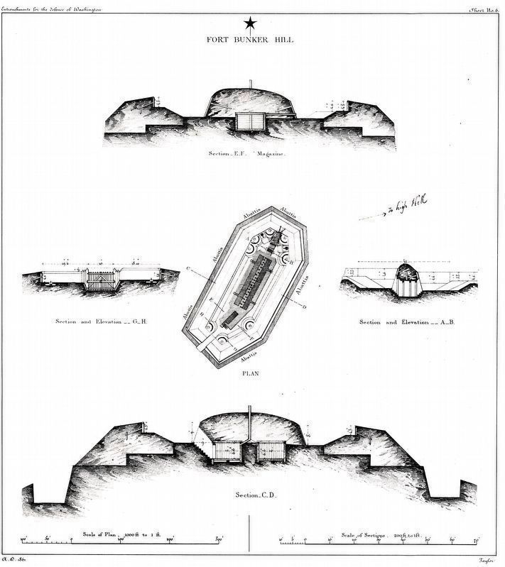
Near Otis Street Northeast near 14th Street Northwest, on the right when traveling west.
One of the Civil War Defenses of Washington erected in the fall of 1861, Fort Bunker Hill occupied an important position between Fort Totten and Fort Lincoln in the defense of the National Capital. Thirteen guns and mortars were mounted in the fort. — — Map (db m111795) HM
On Fort Totten Drive Northeast north of Crittenden Street Northeast, on the right when traveling north.
Earthworks of Fort Totten are visible within the wooded area 50 yards at the top of this hill. Cannon mounted at Fort Totten helped repulse a Confederate attack on Fort Stevens, July 11-12, 1864. — — Map (db m2993) HM
On Fort Totten Drive Northeast north of Allison Street Northeast, on the right when traveling north.
One of the Civil War defenses of Washington construction of Fort Totten was begun in August 1861, named after Gen. Joseph G. Totten the fort contained 20 guns and mortars including eight 32-pounders. — — Map (db m2999) HM
On Minnesota Avenue Northeast at Grant Street Northeast, on the left when traveling south on Minnesota Avenue Northeast.
Formerly known as the Bladensburg Piscataway Road, Minnesota Avenue has long served as an eastern gateway into Washington. Since the original wooden Benning Road Bridge across the Anacostia River was erected nearby in 1800, countless people . . . — — Map (db m136184) HM
On Benning Road Northeast at 41st Street Northeast, on the right when traveling west on Benning Road Northeast.
Fort Mahan
Civil War Defenses of Washington
1861-1865
Earthworks of Fort Mahan are visible; follow path at the top of the hill.
[Illustration:]
Fort Mahan from U.S. Army Corps of Engineers drawing.
- Fort . . . — — Map (db m46083) HM
On River Road Northwest just west of Murdock Mill Road, on the right when traveling west.
Eldbrooke United Methodist Church's roots reach to about 1835, when Methodists gathered at the Loughborough Road home of Philip L. Brooke. Soon they built the simple, wooden Mount Zion Methodist Episcopal Church on land purchased from the . . . — — Map (db m184983) HM
On River Road Northwest at Western Avenue Northwest, on the right when traveling south on River Road Northwest.
Civil War Defenses of Washington 1861-1865. No visible evidence remains of Fort Bayard, which stood at the top of this hill. Named for Brig. Gen. George Bayard, mortally wounded at the Battle of Fredericksburg on December 13, 1862. — — Map (db m124) HM
On Quackenbos Street Northwest east of 13th Street Northwest, on the left when traveling west.
Hearing those words, President Abraham Lincoln ducked down from the Fort Stevens parapet during the Civil War battle that stopped the Confederates from taking Washington. On July 9, 1864, some 15,000 Rebels led by General Jubal A. Early . . . — — Map (db m72829) HM
On 13th Street Northwest at Quakenbos Street Northwest, on the right when traveling north on 13th Street Northwest.
Elizabeth Proctor Thomas (1821-1917), a free Black woman whose image appears on each Brightwood Heritage Trail sign, once owned 11 acres in this area. Known, respectfully in her old age as "Aunt Betty," Thomas and her husband James farmed and . . . — — Map (db m72830) HM
On 13th Street Northwest at Quakenbos Street Northwest, on the right when traveling north on 13th Street Northwest.
Civil War Defenses of Washington 1861-1865 The partial reconstruction of Fort Stevens that you see today was done by the Civilian Conservation Corps in 1937. No visible evidence of the original fort remains. Battle of Fort Stevens July . . . — — Map (db m3028) HM
On Quackenbos Street Northwest near 13th Street Northwest, on the left when traveling east.
Dedicated September 1936 in memory of The Grand Army of the Republic by the Daughters of Union Veterans of the Civil War 1861-1865 — — Map (db m49526) HM
On Chain Bridge Road Northwest north of MacArthur Boulevard Northwest, on the right when traveling north.
Built in the autumn of 1861 and enlarged in 1862, the battery was named for Gouveneur Kemble of Cold Spring, NY, a former superintendent of the West Point Foundry. The battery, which consisted of two 100-pound Parrott guns, was designed to sweep the . . . — — Map (db m142203) HM
On Kansas Avenue Northwest at Nicholson Street Northwest, on the right when traveling south on Kansas Avenue Northwest.
No visible evidence remains of Fort Slocum, which stood here and across Kansas Avenue to your left. Cannon mounted at Fort Totten helped repulse a Confederate attack on Fort Stevens, July 11-12, 1864. — — Map (db m110283) HM
On Oregon Avenue Northwest north of Military Road Northwest, on the right when traveling north.
Earthworks of Fort De Russy are visible; follow path to your right for 200 yards.
[drawing of fort]
Fort De Russy from U.S. Army Corps of Engineers drawing.
Cannon mounted at Fort De Russy helped repulse a Confederate attack on . . . — — Map (db m235916) HM
Near Oregon Avenue Northwest at Military Road Northwest, on the right when traveling north.
One of the Civil War Defenses of Washington. Constructed on the site in 1861 Fort DeRussy commanded the deep valley of Rock Creek. Its armament consisted of 11 guns and mortars including a 100-pounder Parrott Rifle. — — Map (db m20823) HM
Near Oregon Avenue Northwest at Military Road Northwest, on the right when traveling north.
Built in 1861 to protect the Rock Creek Valley during the Civil War, Fort DeRussy's cannon fired a total of 109 projectiles into the northern countryside as 12,000-15,000 Confederate soldiers attacked the city under the command of Confederate . . . — — Map (db m116084) HM
On Georgia Avenue Northwest (U.S. 29) north of Van Buren Street Northwest, on the right when traveling north.
In Memory
of
Our Comrades
Killed and Wounded
in Battle
on This Field
July 11th & 12th 1864
98th Reg't. P.V.
1st Brig., 2nd Div., 6th Corps — — Map (db m76116) WM
Near Georgia Avenue Northwest (U.S. 29) just north of Van Buren Street Northwest, on the right when traveling north.
During the late evening of July 12, 1864, 40 Union soldiers that perished while defending Washington DC from a two day Confederate attack (known as the Battle of Fort Stevens) were laid to rest here in what was once an apple orchard. President . . . — — Map (db m165667) HM
On Georgia Avenue Northwest (U.S. 29) north of Van Buren Street Northwest, on the right when traveling north.
After the rebels were turned back as the Battle of Fort Stevens ended in 1864, scores of Union Soldiers lay cold and silent. Forty-one of them are buried here in this tiny plot dedicated to their sacrifice.
President Abraham Lincoln, who . . . — — Map (db m165669) HM
Near Georgia Avenue Northwest (U.S. 29) north of Van Buren Street Northwest, on the right when traveling north.
As the gallant soldiers that are interred at the cemetery marched onto the battlefield on July 11-12, 1864 during the Battle of Fort Stevens, their regimental flags accompanied then into the fight.
Battleground National Cemetery honors these . . . — — Map (db m64225) HM
Near Georgia Avenue Northwest (U.S. 29) north of Van Buren Street Northwest, on the right when traveling north.
To the gallant sons of Onondaga County, N.Y. who fought on this field July 12, 1864 in defence of Washington and in the presence of Abraham Lincoln
122 N.Y.V. — — Map (db m76093) WM
On Chesapeake Street Northwest west of Nebraska Avenue Northwest, on the left when traveling west.
At an elevation of 410 feet, Fort Reno is located at the highest point in DC. The fort, originally named Fort Pennsylvania, was well situated to provide defense of the Nation's Capital during the Civil War as one of the Circle of Forts (pictured . . . — — Map (db m20628) HM
On Nebraska Avenue Northwest at Chesapeake Street Northwest, on the right when traveling south on Nebraska Avenue Northwest.
No visible evidence remains of Fort Reno, which stood at the top of this hill, the highest elevation in Washington, D.C.
[drawing of Fort Reno]
Fort Reno from U.S. Army Corps of Engineers drawing. Cannon mounted at Fort Reno helped repulse . . . — — Map (db m20629) HM
Near Chesapeake Street Northwest west of Nebraska Avenue Northwest, on the right when traveling west.
At 409 feet above sea level, this site is the highest point in Washington, D.C. It is no coincidence that in 1861, the Union army designed one the largest and most heavily armed Civil War fortifications at this location.
Originally named . . . — — Map (db m133962) HM
At 409 feet above sea level, this site is the highest point in Washington, D.C. It is no coincidence that in 1861, the Union army designed one the largest and most heavily armed Civil War fortifications at this location.
Originally named . . . — — Map (db m136006) HM
On Chesapeake Street Northwest east of 40th Street Northwest, on the left when traveling east.
To your right is "Point Reno," the highest point in Washington — 409 feet above sea level, to be exact.
This unsurpassed vantage brought the Civil War (1861-1865) to Tenleytown. After the Union defeat at Bull Run in July 1861, . . . — — Map (db m130923) HM
On 40th Street Northwest at Chesapeake Street Northwest, on the right when traveling south on 40th Street Northwest.
Before the Civil War (1861-65), the land behind you was part of the 72-acre farm of Giles Dyer. As a Southerner, Dyer depended on enslaved people to work his fields.
Because of its elevation, Dyers land was taken by the Union Army in 1861 . . . — — Map (db m130924) HM
On Chesapeake Street Northwest east of Fort Drive Northwest, on the right when traveling east.
Fort Reno is located at the highest elevation in D.C. A city water reservoir was constructed in the 1890s to serve the city's growing population. The red brick water tower (pictured here) was built in 1903 to provide water pressure to the immediate . . . — — Map (db m112184) HM
On Wisconsin Avenue Northwest, 0.1 miles north of Tenley Circle Northwest, on the right when traveling north.
Top of the Town
Greetings from Tenleytown
altitude 409'
[Pictured on the mural are events and locations significant to Tenleytown's history:]
• Fort Reno Water Towers
• The Tenleytown Streetcar
• Fort Reno and the Civil . . . — — Map (db m150280) HM
On Chesapeake Street, 0.1 miles west of Nebraska Avenue when traveling west.
The site of this fort was selected in August, 1861. First called Fort Pennsylvania, the fort was located at an elevation of 430 feet, commanding three important roads which entered the city from the northwest in the vicinity of what is now Wisconsin . . . — — Map (db m20630) HM
Near Morris Road Southeast west of 16th Street Southeast, on the right when traveling west.
Earthworks of Fort Stanton are visible in the wooded area 200 yards in front of you.
Diagram: Fort Stanton from U.S. Army Corps of Engineers drawing.
Fort Stanton was named for Secretary of War Edwin M. Stanton, was the first fort . . . — — Map (db m46623) HM
On Texas Avenue Southeast at C Street Southeast, on the right when traveling south on Texas Avenue Southeast.
Earthworks of Fort Chaplin are visible through the wooded areas at the top of the hill. Fort Chaplin was named in honor of Col. Daniel Chaplin, who was mortally wounded on August 17, 1864, at Deep Bottom, Virginia. — — Map (db m10628) HM
On Martin Luther King Jr. Avenue Southeast south of Talbert Street Southeast when traveling north.
Across the street is the former Carver Theatre, built in 1948 as the first nonsegregated movie house in Southeast Washington. It closed in 1957 becoming, in turn, a roller rink, a church, and a funeral parlor.
Then a decade later, a . . . — — Map (db m100824) HM
On Martin Luther King, Jr. Avenue Southeast, 0.1 miles north of South Capitol Street Southeast, on the right when traveling west.
Earthworks of Fort Carroll are visible 100 yards to the right at the top of the hill. Fort Carroll was named in honor of Maj. Gen. Samuel Sprigg Carroll, a West Point graduate from the District of Columbia. — — Map (db m10614) HM
On Alabama Avenue Southeast north of Pennsylvania Avenue Southeast, on the left when traveling north.
One of several earthworks commenced late in 1861 to guard the nation’s capital from the ridge east of the Anacostia River. The fort was named in honour of Colonel Benjamin F. Davis of the 8th New York Cavalry, killed at Beverly Ford, Virginia, June . . . — — Map (db m40690) HM
On Alabama Avenue Southeast north of Pennsylvania Avenue Southeast, on the right when traveling south.
Earthworks of Fort Davis are visible behind the wooded area in front of you.
[Captions:]
Fort Davis from the U.S. Army Corps of Engineers drawing.
Fort Davis was named after Col. Benjamin F. "Grimes" Davis, hero at . . . — — Map (db m211965) HM
Near Alabama Avenue Southeast east of Massachusetts Avenue Northeast, on the left when traveling east.
This small work was one of the defenses begun in the fall of 1861 on the ridge east of the Anacostia River. It was named after Admiral Samuel DuPont, a commander of the South Atlantic Blockade Squadron. Eight guns and one mortar comprised its . . . — — Map (db m46425) HM
Near Alabama Avenue Southeast west of Beck Street Southeast, on the right when traveling west.
Earthworks of Fort DuPont are visible; follow path to the entrance of the fort.
[Captions:]
Fort DuPont from U.S. Army Corps of Engineers drawing
Fort DuPont was named after Rear Admiral Samuel Francis DuPont, a Union . . . — — Map (db m206943) HM
On Bruce Place Southeast at Raynolds Place Southeast, on the right when traveling north on Bruce Place Southeast.
Earthworks of Battery Ricketts are visible inside the wooded area in front of you. Battery Ricketts, built to defend an area in front of Fort Stanton, was named for Maj. Gen. James B. Ricketts. — — Map (db m10622) HM
On Elmira Street Southwest at Martin Luther King Jr. Avenue Southwest, on the right when traveling west on Elmira Street Southwest.
Earthworks of Fort Greble are visible beyond this exhibit. Fort Greble was named in honor of Lt. John T. Greble, slain at the Battle of Big Bethel, June 10, 1861, the first U.S. Military Academy graduate killed in the Civil War. — — Map (db m40866) HM
On District Square Southwest just north of Wharf Street Southwest, on the right when traveling south.
During the Civil War, President Lincoln greeted troops upon arriving at the Southwest Waterfront, including Union Soldiers on their way to Fort Stevens to defend Washington from a Confederate Attack. — — Map (db m183749) HM
On Elliott Road, 0.4 miles west of Ashfield Road, on the right when traveling west.
During the Civil War, fortifications were constructed around the perimeter of Washington to defend the city from attack by the Confederate Army. Paramount to survival under siege was protection of the city's water supply. Forts Sumner and Mansfield . . . — — Map (db m17647) HM
On Elliott Road, 0.4 miles west of Ashfield Road, on the right when traveling west.
Born June 4, 1834, in Martinsburg, New York, this 1856 West Point graduate returned to his alma mater as an instructor following a tour of duty in the west and midwest. At the outbreak of the Civil War, Bailey organized the First New York Light . . . — — Map (db m17695) HM
Near Elliott Road, 0.4 miles west of Ashfield Road, on the right when traveling west.
During the Civil War between 1861 and 1865, the Army of the Potomac had a two-fold mission: to defeat the Confederate Army and to defend the City of Washington against enemy attack. To prepare for the possibility of enemy attack, military . . . — — Map (db m174638) HM
On Sangamore Road at Westpath Way, on the left when traveling north on Sangamore Road.
Forts Alexander, Ripley and Franklin, built to protect the Washington water system in 1861, were connected by earthworks in 1863 and renamed Ft. Sumner to honor Maj. Gen. Edwin V. Sumner, A hero of Antietam. The fort’s 28 cannon providea a . . . — — Map (db m3448) HM
Near Elliott Road, 0.4 miles west of Ashfield Road, on the right when traveling west.
Battery - a fortification formed by moving earth or other materials into hill-like formations to protect artillery, having the following components:
Parapet - an elevation of earth that protects soldiers from attack.
Terreplain . . . — — Map (db m174636) HM
Near Bladensburg Road (Maryland Route 450) 0.2 miles west of 38th Avenue, on the left when traveling west.
These earthworks are a portion of the original fortifications which made up Fort Lincoln. This fort was built during the summer of 1861 to serve as an outer defense of the city of Washington. It was named in honor of President Lincoln by General . . . — — Map (db m46714) HM
Near Bladensburg Road (Alternate U.S. 1) east of Eastern Avenue, on the right when traveling north.
These earthworks are a portion of the original fortifications which made up Fort Lincoln. This fort was built during the summer of 1861 to serve as an outer defense of the city of Washington. It was named in honor of President Lincoln by General . . . — — Map (db m206600) HM
Near Bladensburg Road (Alternate U.S. 1) east of Eastern Avenue, on the right when traveling north.
1680 • Original land granted from Lord Baltimore to George Conn
1683 • Old Spring House erected - One of the oldest buildings in the State of Maryland
1800 - 1859 • The Dueling Grounds - Site of the 1820 duel between Steven Decatur and . . . — — Map (db m206605) HM
On Bladensburg Road, 0.2 miles south of 37th Street, on the left when traveling south.
Fort Lincoln Cemetery was chartered in 1912 by an act of the Maryland General Assembly and presently contains 178 acres.
Here, at Fort Lincoln Cemetery, masterworks of marble, granite and bronze stand in solemn dignity and provides a . . . — — Map (db m151234) HM
Near Fort Foote Road at Jessica Drive, on the right when traveling south. Reported permanently removed.
Among the largest cannon used in the Civil War Monumental in size, these two immense guns remain as sentinels ready to repel an attack on the Nation's capital. With their extended range and commanding location above the river, they were the key . . . — — Map (db m7636) HM
Near Fort Foote Road. Reported permanently removed.
High on a bluff, a hundred feet above the Potomac River, twelve heavy guns commanded the approach to the city. Smaller cannon were placed to protect Fort Foote from landward attack. Numerous buildings were constructed to house and support the large . . . — — Map (db m187119) HM
On Fort Washington Road, on the right when traveling west.
Fort Washington Park is the site of the first permanent fort constructed between 1814-1824 to guard the Potomac River approach to our Nation's Capital. Today the park offers many recreational opportunities and programs. Explore the historic sites . . . — — Map (db m4554) HM
Near Fort Foote Road. Reported permanently removed.
Capt. Rufus King, Jr. devised a counterweight system and front-pintle mount that would allow the 49,000 pdr. Rodman Gun to depress during loading. Except for the brief periods of exposure to enemy fire during the aiming and firing of the gun, the . . . — — Map (db m187211) HM
Near Fort Foote Road, on the right when traveling west. Reported permanently removed.
Protecting the fort against land attack Armed with smaller field and siege guns, the landward bastions could deliver a sustained cannonade of 12- and 30-pounder shells. The long central traverse provided protection and contained magazines and . . . — — Map (db m187213) HM
Near Fort Foote Road, on the right when traveling west. Reported permanently removed.
At the start of the Civil War, Washington was protected by only one fort, Fort Washington guarding the Potomac River approach. The capital city was uncomfortably close to Confederate forces operating in Northern Virginia. by 1864, a system of . . . — — Map (db m7635) HM
On South Lee Street at Green Street, on the right on South Lee Street.
Historical Site Defenses of Washington 1861-1865 Battery Rodgers
Here stood Battery Rodgers, built in 1863 to prevent enemy ships from passing up the Potomac River. The battery had a perimeter of 30 yards and mounted five 200 pounder Parrott . . . — — Map (db m41413) HM
On West Braddock Road, 0.2 miles west of Marlboro Drive, on the right when traveling west.
African Americans established "The Fort," a community that continued here after the Civil War (1861-1864) for nearly a century into the Civil Rights Era of the 1960s. The place received its name from The Fort's location around the remnants of . . . — — Map (db m149722) HM
On West Braddock Road, 0.2 miles west of Marlboro Drive, on the right when traveling west.
The Civil War (1861-1865) opened the door for opportunity and civil rights for African American Virginians, about 90 percent of whom were enslaved in 1860. The upheaval from battles and the federal presence in Alexandria and eastern Fairfax . . . — — Map (db m149734) HM
Near West Braddock Road, on the right when traveling west.
Two bombproofs, each measuring 200 feet long by 12.5 feet wide, were located in the center of Fort Ward. During normal operations the bombproofs were used as meeting rooms, storage facilities, and sometimes as a prison. In the event of an attack, . . . — — Map (db m7716) HM
On West Braddock Road, on the right when traveling east.
The Fort Ward entrance gate, completed in May 1865, provided the only access to the interior of the fort. The gate's decorative details include stands of cannonballs and the insignia (castle) of the Army Corps of Engineers which designed and . . . — — Map (db m194339) HM
Near West Braddock Road, on the right when traveling west.
On May 24, 1861, when Virginia's secession from the Union became effective, Federal forces immediately occupied Northern Virginia to protect the City of Washington, D.C. After the Confederate victory at the Battle of First Bull Run (First Manassas) . . . — — Map (db m7676) HM
Near West Braddock Road, on the right when traveling west.
This stairway leads up the west wall of Fort Ward between the Northwest Bastion (to the left) and the Southwest Bastion (to the right). Fort Ward had 14 cannon emplacements along this area of the wall that created overlapping fields of fire. . . . — — Map (db m7709) HM
Historical Site Defenses of Washington 1861-1865 Fort Ward Here stands Fort Ward, constructed in 1861 to protect the approaches to Alexandria by Little River Turnpike and Leesburg Turnpike. In 1864, the fort was enlarged to a perimeter of 818 . . . — — Map (db m41117) HM
On North Quaker Lane at Coventry Lane, on the left when traveling north on North Quaker Lane.
Historical Site
Defenses of Washington
1861 - 1865
100 yards to the west stood Fort Williams, built in 1863 to guard the approaches to Alexandria by Little River Turnpike and Telegraph Road. It had a perimeter of 250 yards and emplacements . . . — — Map (db m80467) HM
On St Stephens Road west of North Garland Street, on the left when traveling west.
Historical Site
Defenses of Washington
1861 - 1865
Here stood Fort Worth, built in 1861. It had a commanding view of the Cameron Valley and guarded the approach to Alexandria by Little River Turnpike. The fort had a perimeter of 463 yards . . . — — Map (db m80466) HM
The plan of Fort Ward consisted of five bastions with positions for 36 guns. The Northwest Bastion illustrates how the entire stronghold appeared in 1864. This bastion is armed with six reproduction weapons based on Fort Ward's original table of . . . — — Map (db m7713) HM
Near West Braddock Road, 0.1 miles west of Marlboro Drive, on the right when traveling west.
This outlying 6-gun battery was constructed to cover the ravine where Interstate 395 is located today. The remains of a covered-way rifle trench that extended from the Northwest Bastion is visible near the park road. This trench provided protection . . . — — Map (db m149735) HM
Near West Braddock Road, on the right when traveling west.
Ammunition for the fort's guns was kept in underground storage facilities called magazines and filling rooms. Shells were armed and sometimes stored in the filling room, while the magazine was used to hold black powder and crated rounds. Implements . . . — — Map (db m7711) HM
Near West Braddock Road, on the right when traveling west.
This exterior view of the restored Northwest Bastion illustrates the effectiveness of an earthwork fort. The fort walls were 18-22 feet high, 12-14 feet thick, and slanted at 45 degrees. To gain access to the fort an attacker would have to cross . . . — — Map (db m7714) HM
Near West Braddock Road, on the right when traveling west.
This rifle trench extended from the North Bastion toward Battery Garesche located beyond Leesburg Turnpike (Route 7). Another rifle trench extended from the tip of the South Bastion near the Fort Gate. The rifle trenches prevented enemy troops from . . . — — Map (db m7715) HM
Near West Braddock Road, 0.2 miles west of Marlboro Drive, on the right when traveling west. Reported damaged.
The Southwest Bastion was the most heavily fortified area of the fort with emplacements for seven guns, as well as a magazine and a filling room. The largest gun in Fort Ward, a 100-pounder Parrott Rifle, was located in the Southwest Bastion. . . . — — Map (db m7684) HM
Near Wilkes Street west of Hamilton Avenue when traveling west.
Securing the Capital
On May 24, 1861, Gen. Winfield Scott ordered eleven regiments of Union troops from Washington, D.C., across the Potomac River, where they captured Arlington and Alexandria.
After their defeat in July at Manassas, . . . — — Map (db m92113) HM
On Roberts Lane, 0.3 miles north of Duke Street (Virginia Route 236), on the left when traveling north.
Fort Ellsworth, one of 68 earthen forts built to protect Washington during the Civil War, was constructed in 1861. When completed, the fort had a perimeter of 618 yards and was an irregular Vauban-type star design of French origin. The fort was . . . — — Map (db m45046) HM
On Fort Scott Drive, on the right when traveling east.
Historical Site Defenses of Washington 1861-1865 Fort Scott Here stood a detached lunette constructed in May, 1861, to guard the south flank of the defenses of Washington and named for General Winfield Scott, then General-in-Chief of the Army. . . . — — Map (db m5257) HM
Here is what is left of Fort Richardson, a detached redoubt constructed in September, 1861, to cover the left flank of the newly built Arlington defense line, It was named for General Israel B. Richardson, whose division was then deployed to defend . . . — — Map (db m39726) HM
On Arlington Boulevard (U.S. 50) at 10th Street North, on the right when traveling east on Arlington Boulevard.
During the Civil War, the Union built a series of forts to defend Washington, D.C. By 1865 there were 33 earthen fortifications in the Arlington Line. Fort Cass (1861) was part of this defensive strategy. Built on top of the rise east of this . . . — — Map (db m5141) HM
On North Courthouse Road at North 14th Street, on the right when traveling south on North Courthouse Road.
During the Civil War, the Union built a series of forts to defend Washington, D.C. By 1865 there were 33 earthen fortifications in the Arlington Line. Fort Woodbury (1861) was part of this defensive strategy. Built east of this marker, this lunette . . . — — Map (db m5138) HM
Near 6th Street South east of Long Bridge Drive, on the right when traveling east.
This point has long been a vital gateway for commerce and travelers. In the early 1800s, the first Long Bridge connected Alexandria traders and Virginia farmers with Washington and Georgetown. Now, cars, trains, and the Metro carry people and goods . . . — — Map (db m134979) HM
On 6th Street South east of Long Bridge Drive, on the right when traveling east.
" … a detail of men with axes was marched … to the place afterwards known as 'Fort Runyon' and proceeded to level the ground of a fine peach orchard of three hundred trees."
Emmons Clark,
History of the Seventh . . . — — Map (db m134984) HM
On 6th Street South east of Long Bridge Drive, on the right when traveling east.
Following the end of the Civil War, Fort Runyon was dismantled, the garrison sent home, and the land returned to its owner, James Roach. Squatters — among them freed blacks — occupied the vacant fort, scavenging its timbers for building . . . — — Map (db m134989) HM
On 6th Street South east of Long Bridge Drive, on the right when traveling east.
Fort Runyon once stood on this site. Built by Union troops at the start of the Civil War, the fort guarded access to the Virginia end of the Long Bridge, which led directly across the Potomac River to the heart of Washington, D.C. The fort . . . — — Map (db m134981) HM
On 6th Street South east of Long Bridge Drive, on the right when traveling east.
7th Regiment New York Militia Infantry ★ May 1861 ★ Construction
2d New Jersey Infantry (three months) ★ May 1861
3d New Jersey Infantry (three months) ★ May 1861
21st New York Infantry ★ May - August 1861 . . . — — Map (db m134988) HM
On 6th Street South east of Long Bridge Drive, on the right when traveling east. Reported damaged.
Fort Runyon was the largest in area of 164 Civil War forts and batteries built in Virginia, Maryland, and the District of Columbia. The Defenses of Washington, as they were known, formed a 37-mile ring around the capital as protection from . . . — — Map (db m134983) HM
On 6th Street South east of Long Bridge Drive, on the right when traveling east.
Virginians voted overwhelmingly for secession form the Union on May 23, 1861. Overnight, Union Army troops stationed in Washington, D.C., moved to occupy what is now Arlington County. The main body of the troops crossed the Potomac River via the . . . — — Map (db m134982) HM
On 6th Street South east of Long Bridge Drive, on the right when traveling east.
The men who built Fort Runyon and were garrisoned there typified the soldiers of the Union Army. Their ranks were drawn from militia and all-volunteer regiments organized by the states and mustered into national service. They arrived in camp . . . — — Map (db m134986) HM
On South Glebe Road (Virginia Route 120) at South Walter Reed Drive, on the right when traveling south on South Glebe Road.
Immediately to the west stood Fort Berry, a redoubt constructed in 1863 at the north flank of the defenses of Alexandria, but also flanking the Columbia Turnpike and the Arlington Line constructed in 1861. It had a perimeter of 215 yards and . . . — — Map (db m5154) HM
On Arlington Boulevard (U.S. 50) at North Pershing Drive, on the right when traveling east on Arlington Boulevard.
On the high ground to the northeast stood Fort Whipple, a bastioned earthwork built early in 1863 to support the Arlington Line built in 1861. It had a perimeter of 640 yards and emplacements for 47 guns. After the War, Fort Whipple was maintained . . . — — Map (db m5140) HM
On South Pollard Street at South Walter Reed Drive, on the left when traveling south on South Pollard Street.
Here stood Fort Barnard, a redoubt constructed late in 1861 to command the approaches to Alexandria by way of Four Mile Run and Glebe Road. It was named for General J. G. Barnard, Chief Engineer of the Defenses of Washington. It had a perimeter of . . . — — Map (db m5158) HM
On Clark Street at Boundary Channel Drive, on the right when traveling north on Clark Street.
A half-mile to the southwest stood Fort Runyon, a large bastioned earthwork constructed in May 1861 to protect the Long Bridge over the Potomac. Its perimeter, 1484 yards, was about the same as that of the Pentagon. After the construction of the . . . — — Map (db m5255) HM
On Arlington Boulevard (U.S. 50) at North 2nd Street, on the right when traveling south on Arlington Boulevard.
Here stood Fort Tillinghast, a lunette in the Arlington Line constructed in August 1861. It had a perimeter of 298 yards and emplacements for 13 guns. A model of this fort, typical of all lunettes in the Arlington Line, can be seen at the Hume . . . — — Map (db m5147) HM
On 22nd Street North, on the right when traveling east.
Historical Site Defenses of Washington 1861-1865 Fort Bennett Here stood Fort Bennett, a small outwork of Fort Corcoran, constructed in May 1861. With a perimeter of 146 yards and emplacements for 5 guns, it was designed to bring under fire the . . . — — Map (db m5104) HM
On Langston Boulevard (U.S. 29) at North Adams Street, on the right when traveling south on Langston Boulevard.
Nearby to the north stood Fort Strong, a lunette marking the north end of the Arlington Line constructed in August 1861. It had a perimeter of 318 yards and emplacements for 15 guns. — — Map (db m5112) HM
146 entries matched your criteria. The first 100 are listed above. The final 46 ⊳