The legendary but true bloody feud between the Hatfield clan of West Virginia and the McCoy clan of Kentucky that began in 1865 and ended in a truce in 1928.
Near Cemetery Road (Local Route 3294) at 36th Street and Radio Park Road (Local Route 3294).
James H. McCoy. Oldest son of Randall and Sarah. Last living McCoy feudist before passing away in 1929. He was a peacemaker in the feud and tried to talk Frank Phillips out of killing Jim Vance & Bill Dempsey. In 1928, James & Tennis Hatfield, . . . — — Map (db m126114) HM
On Kentucky Route 1056 just south of River Street, on the right when traveling north.
This episode is the result of the infamous August 1882 election day fight. Randolph McCoy's son Tolbert engaged in a heated argument with "Devil Anse" Hatfield's brother Ellison. This lead to a fight in which Tolbert, and his brothers Pharmer and . . . — — Map (db m162516) HM
On Kentucky Route 319, 0.7 miles west of Right Turkey Toe Branch, on the left when traveling west.
HARDY, Ky. - What do you get when you combine clear, fresh well water from the original McCoy family log
cabin site with Pauley Hollow Distillery? Real Appalachian moonshine made in Pike County, Kentucky.
The old rustic water well of Randal . . . — — Map (db m162517) HM
On Kentucky Route 312, 0.7 miles west of Right Turkey Toe Branch, on the right when traveling east.
Nestled at Hardy, Kentucky in a spectacular mountain valley, the Randal
McCoy well still stands. The well is 25 to 30 feet deep, and if it could talk it
would say, "I'm now enjoying the scenery, heritage and especially the
friendly people who . . . — — Map (db m162519) HM
On Kentucky Route 319, 0.2 miles east of Compton Road, on the left when traveling east.
House was located on Blackberry Fork of Pond Creek. It burned Jan. 1, 1888, during a Hatfield raid. Two of Randolph's children, Alifair and Calvin, were killed in attack; their mother Sally was badly injured. Randolph and other children escaped. . . . — — Map (db m55887) HM
On State Highway 319, 0.7 miles Right Turkey toe Branch, on the left when traveling west.
Newly Discovered Artifacts at Patriarch Randall McCoy's Home
in Rural Hardy, Kentucky,
Uncover Clues About Infamous
McCoy and Hatfield 1888 Showdown
2013 Marks the 125” Anniversary of the Legendary
Hatfield-McCoy New Year's Day . . . — — Map (db m162521) HM
On Toler Road (Kentucky Route 319) west of Kentucky Route 1056, on the right when traveling west.
(obverse)
In 1873 Randolph McCoy accused Floyd Hatfield of stealing his hog. A trial followed, presided over by Reverend Anderson Hatfield, justice of the peace. To be fair, the jury consisted of six Hatfields and six McCoys. One witness, . . . — — Map (db m50663) HM
On Toler Road (Kentucky Route 319) west of Kentucky Route 1056, on the right when traveling west.
In the fall of 1878, Randolph McCoy brought charges against Floyd Hatfield for stealing one of his hogs. The resulting trial occurred here and was presided over by the local justice of the peace, Preacher Anderson Hatfield. Preacher Anderson was . . . — — Map (db m50667) HM
On Toler Road (Kentucky Route 319) 0.1 miles west of Kentucky Route 1056, on the right when traveling west.
Among the graves in the McCoy Cemetery are those of Randolph McCoy's three sons - Tolbert, Pharmer, and Randolph Jr. - all killed by the Hatfields. Also buried here are Alifair and Calvin McCoy, who were killed by the Hatfields when cabin was . . . — — Map (db m50661) HM
On Kentucky Route 1056 south of River Street, on the right when traveling north.
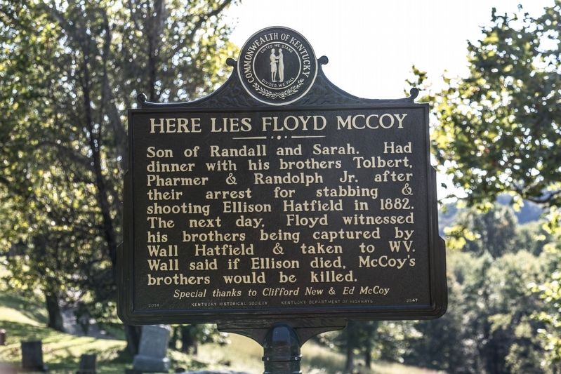
This episode is result of August 1882 election-day fight. Tolbert, a son of Randolph McCoy, exchanged heated words with Ellison Hatfield, which started a fight. Tolbert, Pharmer and Randolph McCoy Jr. stabbed Ellison to death. Later the three . . . — — Map (db m50662) HM
Near Chloe Road (Kentucky Route 1460) east of South Bypass Road (Kentucky Route 1460), on the left when traveling east.
Colonel John Dils purchased the property in 1871 on which this cemetery is located. He was the colonel of the 39th Kentucky Infantry in the Civil War. In addition to Colonel Dils, there are several Civil war veterans buried here with the original . . . — — Map (db m146195) HM
On Kentucky Avenue, on the left when traveling north.
Hanging site of Ellison Mounts, Feb. 18, 1890. Seven other Hatfield supporters indicted for murder of Alifair McCoy were sentenced to life in prison. By the time of his trial, Mounts had confessed. He was also found guilty, but the jury recommended . . . — — Map (db m50815) HM
On Chloe Road (Kentucky Route 1460) east of South Bypass Road (Kentucky Route 1460), on the right when traveling east.
The feud resulted, in part, from
Civil War conflicts, romantic
entanglements, family-oriented
discord, property and election
disputes, mixed with mountain
pride. Violence surrounding clan
leaders Anderson Hatfield and
Randolph McCoy . . . — — Map (db m146181) HM
On Scott Avenue at Main Street, on the right when traveling east on Scott Avenue.
After Hatfields burned the McCoy home, January 1, 1888, Randolph and Sarah McCoy never returned to Blackberry Creek. Governors of Ky. and West Va. urged Hatfields and McCoys to move away from each other. McCoys purchased house near river bank on . . . — — Map (db m50673) HM
On Division Street east of Main Street, on the right when traveling east.
Courthouse erected 1888-89 by McDonald Bros.; later renovated 1932-33. Here was scene of Hatfield clan trials for murders of Tolbert, Randolph, Jr., Pharmer, Alifair, and Calvin McCoy. The defendants lodged in adjacent jail; found guilty and . . . — — Map (db m56342) HM
On Big Blue Springs Road south of State Route 1056, on the left when traveling south.
Asa Harmon McCoy, a Union soldier, was shot in 1865 by the Logan Wildcats. The Wildcats were led by Confederate "Devil Anse" Hatfield. Jim Vance was the suspected leader in the murder, although there was never a conviction. This was the first . . . — — Map (db m50660) HM
On Lower Stringtown Road at Kentucky Route 292, on the right when traveling west on Lower Stringtown Road.
Sarah Elizabeth, “Little Sally,” was the daughter of Roseanna
McCoy and Johnse Hatfield. She was born in the spring of
1881 and died when she was only eight months old. In 1880,
Roseanna met Johnse at an Election Day celebration . . . — — Map (db m146138) HM
Near Lower Stringtown Road at Kentucky Route 292, on the right when traveling west.
Sarah Elizabeth, “Little Sally,” was the daughter of Roseanna
McCoy and Johnse Hatfield. She was born in the spring of
1881 and died when she was only eight months old. In 1880,
Roseanna met Johnse at an Election Day celebration on
Blackberry . . . — — Map (db m146139) HM
On Kentucky Route 292 at Lower Stringtown Road, on the right when traveling south on State Route 292.
Sally McCoy. Sarah Elizabeth (Sally) McCoy was the daughter of Rosanna McCoy and Johnse Hatfield. Her parents’ love affair played a role in the infamous Hatfield-McCoy feud. Although circumstances prohibited the two from marrying, the child . . . — — Map (db m146141) HM
On Jerry West Highway (West Virginia Route 44), on the right when traveling south.
Capt. Anderson "Devil Anse" Hatfield, 1839-1921, is buried here. He was the leader of his clan in the bitter family feud with the McCoys. A life-sized statue, modeled from photographs and imported from Italy, marks his grave. — — Map (db m49912) HM
On Warm Hollow Road at Magnolia Avenue (West Virginia Route 49), on the right when traveling north on Warm Hollow Road.
With roots extending back years, this famous family feud erupted fully after an 1882 election day brawl in Pike County, Kentucky, between 3 sons of Randolph McCoy and Ellison Hatfield, brother of "Devil Anse.” After Ellison died, the McCoys were . . . — — Map (db m164955) HM
On Mate Street (West Virginia Route 49) at Bridge Street, on the left when traveling south on Mate Street.
John W. English. “We had an idea. Build trails for riders from all over the country to come here to enjoy the
beautiful mountains and to interact with the people of West Virginia.
Build the trails on private property with the cooperation of . . . — — Map (db m178367) HM
On State Highway 1056 at Main Street, on the right when traveling south on State Highway 1056.
Matewan and the surrounding area have a rich and sometimes violent history that revolves around coal, the railroad and flooding. In the early 19th century, the Ferrell family settled in the area along the northern edge of Tug Fork and a then-unnamed . . . — — Map (db m87949) HM