On E Street Southwest at 7th Street Southwest on E Street Southwest.
Behind you stands St. Dominic Church, established 1852. It anchors the city's only Dominican parish and is its sixth oldest Catholic church. St. Dominic's survived two upheavals — a fire in 1885 and the threat of urban renewal in the . . . — — Map (db m130907) HM
On 4th Street Southwest south of G Street Southwest.
Al Jolson, star of the first "talking" movie, The Jazz Singer, grew up as Asa Yoelson at 713 4½ Street (once near this sign). The Yoelsons arrived from Lithuania in 1880. Asa's father Rabbi Moses Yoelson served as cantor and . . . — — Map (db m130905) HM
On Water Street Southwest west of 6th Street Southwest, on the right when traveling south. Reported missing.
Before bridges spanned the Potomac, ferry boats took people and goods across the river. You could ride to Alexandria from Greenleaf’s Point (now Fort McNair), or between the landings where today’s 14th Street Bridge touches ground. Sailboats . . . — — Map (db m130910) HM
On L'Enfant Plaza Southwest at Banneker Circle Southwest, in the median on L'Enfant Plaza Southwest.
This high ground serves as a monument to Benjamin Banneker, the free African American who charted the stars for the first survey of Washington, DC. Banneker was 60 years old when he hired on to assist surveyor Andrew Ellicott. A tobacco . . . — — Map (db m130909) HM
On 4th Street Southwest at N Street Southwest, on the right when traveling north on 4th Street Southwest.
When urban renewal threatened to destroy three of Washington's oldest structures, dating from the late 1700's, history-minded citizens organized to stop the bulldozers. As a result, when architect Chloethiel Woodard Smith designed the . . . — — Map (db m130917) HM
On M Street Southwest at 4th Street Southwest, on the right when traveling west on M Street Southwest.
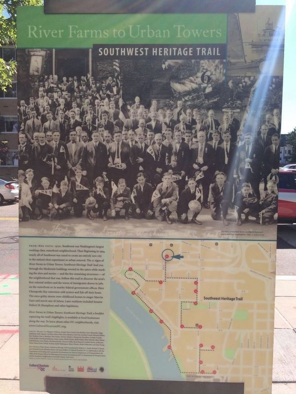
You are standing in the heart of one of Washington, DC's oldest—and newest—neighborhoods. For 150 years Southwest Washington was a working waterfront community. Then urban renewal changed the landscape forever. Today Southwest is . . . — — Map (db m130903) HM
On 7th Street Southwest at G Street Southwest on 7th Street Southwest.
Jefferson Junior High School was built in 1940 after area residents persuaded the city to abandon the original dilapidated building. They hoped the new structure, which included a branch library, would be the beginning of section-wide . . . — — Map (db m130908) HM
On 7th Street Southwest at Maine Avenue Southwest, in the median on 7th Street Southwest. Reported missing.
Before the Civil War, Washington was a slave-holding city. But many of its citizens–especially free blacks and abolitionists–assisted freedom seekers at locations known as stops on the Underground Railroad.
The largest . . . — — Map (db m112455) HM
On P Street Southwest at 3rd Street Southwest, on the right when traveling west on P Street Southwest.
In the 1890s, American cities had a common problem. The working poor lived in deteriorating housing, often no better than wooden shacks. In Washington much of this housing lined the city's hidden alleys. But people needed healthier and safer . . . — — Map (db m130914) HM
On 4th Street Southwest at O Street Southwest, on the right when traveling north on 4th Street Southwest.
A massive, Romanesque style Metropolitan Street Railway car barn once commanded the corner behind you across O Street, with repair shops across Fourth Street. They dated from the 1880s, and were part of Washington's first street railway system. . . . — — Map (db m130915) HM
On P Street Southwest east of 4th Street Southwest, on the right when traveling west.
Fort Leslie J. McNair, to your right, honors the commander, Army Ground Forces during World War II who died in battle. It is the U.S. Army’s third oldest installation (after West Point and Carlisle Barracks).
The fort dates back to 1791. . . . — — Map (db m130912) HM
On 6th Street Southwest north of M Street Southwest, on the right when traveling north.
All that surrounds this sign resulted from the nation's first urban renewal project. To your left is Arena Stage, a leader in the resident company theater movement. Founded as an innovative theater-in-the-round in an old downtown movie . . . — — Map (db m133833) HM
On N Street Southwest east of 4th Street Southwest.
Washington's schools and playgrounds were legally segregated from 1862 until 1954. But that didn't stop kids of all backgrounds from playing together. "We didn't understand racial disharmony," said Southwester Gene Cherrico of his childhood on . . . — — Map (db m130916) HM
On 4th Street Southwest at G Street Southwest, on the right when traveling south on 4th Street Southwest.
Directly across Fourth Street from this sign is the Capitol Park complex of high-rise and townhouse residences. Designed by Chloethiel Woodard Smith of Satterlee and Smith, the high-rise (now Potomac Place) opened in 1959 as the first new . . . — — Map (db m130906) HM
On 6th Street Southwest east of Water Street Southwest, on the right when traveling east.
More than 50 years after it opened in 1964, Tiber Island stands as a tribute to the idealism that marked the new Southwest. Planners hoped the neighborhood's mid-20th-century modern architecture, mix of high- and low-rise structures, balance . . . — — Map (db m130607) HM
On I Street Southwest at 4th Street Southwest on I Street Southwest.
This quiet street was once Washington's answer to New York's Lower East Side. Fourth Street, known until 1934 as a 4½ Street, and nearly Seventh Street were Southwest's shopping centers.
Around 1900 this street was the dividing . . . — — Map (db m130904) HM
On Water Street Southwest south of 6th Street Southwest. Reported missing.
To your left across Water Street is the Thomas Law House, now a community center for the Tiber Island cooperative. The Federal style house was designed by William Lovering in 1794 for businessman Thomas Law and his bride Eliza Parke Custis, . . . — — Map (db m130911) HM