This hostelry originally built in 1855 by J. L. Sperry of Sperry Flour fame and his partner John Perry. Among early guests whose names appear on old register are Mark Twain, Horatio Alger, Thomas H. Lipton, Henry Ward Beecher, the Rothchilds General . . . — — Map (db m143521) HM
Constructed by Peter L. Traver in 1856, this is the oldest stone building in Murphys. Its iron shutters and sand on the roof protected it from the fires of 1859, 1874, and 1893. It served as a general store, a Wells Fargo office, and later a garage. — — Map (db m2611) HM
A thriving mining camp on rich Pennsylvania Gulch in the 1850’s and 1860’s. Named for Alfred Brown, former owner of Table Mountain Ranch. Laws of Brownsville Mining District provided that each miner could own one wet and one dry claim, not to exceed . . . — — Map (db m11501) HM
This historic mining town, elevation 2,600 feet, was founded in 1849 and named after primitive, mule-drawn ore cars used here. The center of rich placer and quartz mining, its largest producer was the Petticoat Mine. As a result of black fever, . . . — — Map (db m239873) HM
Founded February 18, 1850. Became county seat of Calaveras County. Old court house, said to be constructed of lumber brought from China, is still standing but not on the original site. — — Map (db m152282) HM
Located on the Stockton-Murphy Road at the fourth crossing of the Calaveras River, this early mining settlement, once called Foremans, was famous in the 1850's for its rich placer ores. Later, it became an important stage and freighting depot and . . . — — Map (db m11969) HM
Settled by Mexicans in 1848. Named after Catholic Parish of St. Andrew. First newspaper published here Sept. 24, 1856. Destroyed by fire June 4, 1858 and in 1863. County seat of Calaveras County since 1866. Rendezvous of Joaquin Murietta. Black . . . — — Map (db m11503) HM
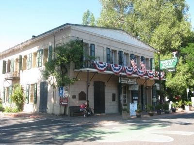
One of California's important early day mining towns named by Mexicans meaning Little Valley. Gold was discovered here by the Murphy Brothers on 1849. It was originally called "Murphys' Old Diggings". This bell was cast at Troy N.Y. in 1853. . . . — — Map (db m6841) HM
Founded February 18, 1850. Became county seat of Calaveras County. Old court house, said to be constructed of lumber brought from China, is still standing but not on the original site. — — Map (db m149318) HM
Gwin Mine, Paloma, and Lower Rich Gulch were mined for placer in 1849. Quartz was discovered by J. Alexander in 1851. Property acquired by Wm. M. Gwin, California's first U.S. Senator, in 1851. The Gwin Mine closed, in 1908, yielded millions. — — Map (db m14449) HM
The original three foot narrow gauge line was built by the San Joaquin & Sierra Nevada Railroad, extending from Brack’s Landing on the Mokelumne River, east to Valley Springs. The depot and turntable were built around the time of completion of the . . . — — Map (db m10635) HM
This site, in 1849, was a trading center for pioneer miners of Northwestern Calaveras County. It was named after the gulch where William and Dan Carsner found large nuggets imbedded in the course sand.
Water for mining was brought from the Middle . . . — — Map (db m11975) HM
Named by famous scout Kit Carson while searching for pass over Sierras. One emigrant road forked at Big Meadows, and north branch came directly to West Point. A thriving trading post prior to gold discovery. Bret Harte, famous author, lived here for . . . — — Map (db m44371) HM
Erected in 1861, this Federal/Classic Revival style building is the oldest remaining courthouse in the Sacramento Valley. The “Southern” style reflects the county’s heritage from the Ante-Bellum South and states-rights sympathies during . . . — — Map (db m57626) HM
This valley was settled in 1855 by Jack and David
Lett. The present lake spillway is the site of a
tunnel built by them to facilitate drainage. Both
brothers were killed in 1877, at the site of the
present camp grounds, in an attempt to . . . — — Map (db m241713) HM
From 1860 to 1906, this area was the largest coal mining district in California. Five towns (Nortonville, Somersville, Stewartville, Judsonville and West Hartley) grew up around twelve major mines. Today the towns are gone. The buildings having been . . . — — Map (db m139449) HM
Erected 1844. Restored 1941 by Contra Costa Horsemans Association.
Fernando Pacheco Adobe. Concord Historical Landmark. Built in 1844-51. Concord Historical Society. — — Map (db m217089) HM
This was the first American home in Crockett. Constructed in 1867 by Thomas Edwards, Sr., on land purchased in 1866 from Judge J.B. Crockett. Located on an earlier Indian village near the Carquinez Straits, its timbers, some of which were brought . . . — — Map (db m12153) HM
Fages, Commandante at Monterey, vainly looked for a way across San Francisco Bay. With Juan Crespi, Franciscan missionary, 14 soldiers, a muleteer and an Indian servant, he trekked along Carquinez Strait, thence eastward nearly to Antioch. Turning . . . — — Map (db m91703) HM
Mount Diablo, sacred to Native Americans who lived and worshipped there for over 5,000 years became a critical reference point for Spanish explorers in the 18th century, and American trappers and early California settlers in the 19th. In 1851 . . . — — Map (db m17541) HM
Four hundred feet west of this plaque Victor Ramon Castro
1817 - 1900 built three adobe dwellings, the south one in
late 1830's the main one or west one in 1840's the
north in late 1840's They with later additions were
destroyed by fire April . . . — — Map (db m144264) HM
Ranch home of John Muir 1838- 1914, explorer, naturalist, author and foremost advocate of forest protection and of national parks. The John Muir Trail through the High Sierra, Muir Woods National Monument and Muir Glacier in Alaska are named for . . . — — Map (db m51132) HM
In 1849, Vicente Martinez built a two-story adobe ranch house on his portion of the Rancho Pinole. This land was inherited from his father, Don Ignacio Martinez, a Spanish officer who became Comandante of the San Francisco Presidio and later Alcade . . . — — Map (db m50821) HM
Built in 1841, the Joaquin Moraga Adobe in Orinda is the oldest surviving building in Contra Costa County. It has been recognized as a California State Historic Landmark since 1954, and was designated as an Orinda City Landmark in 1995.
The . . . — — Map (db m158344) HM
During the World War II Home Front effort, the Richmond Shipyards were an immense facility
covering 880 acres. Constructed for the Henry J. Kaiser Company in 1941 and 1942, these shipyards
became the largest in the world. New methods of ship . . . — — Map (db m146451) HM
Pt. Pinole is the last site of the Giant Powder Company, the first company in America to produce dynamite. Following devastating explosions at their San Francisco and Berkeley sites, the business moved to this isolated location in 1892. . . . — — Map (db m143396) HM
In 1928, San Pablo Ave. (U.S. 40) became part of America's 3,384 mi.
'Lincoln' Transcontinental Highway.
Marker rededicated April 10, 1988. — — Map (db m153013) HM
The Battery Point Lighthouse is one of the first lighthouses on the California Coast.
Rugged mountains and unbridged rivers meant coastal travel was essential for the economic survival of this region.
In 1855 Congress appropriated $15,000 for . . . — — Map (db m101692) HM
A United States military post was established here September 12, 1862 by the men of Company G, 2nd Regiment, Infantry, California Volunteers, to keep peace between the Indians and the miners and settlers of northwestern California. It was abandoned . . . — — Map (db m176820) HM
Constructed in 1858, this was the route of the Crescent City Turnpike. Following the present Elk Valley Road to Old Camp Lincoln, it then crossed the ridge, forded Smith River to low divide, and continued to Jacksonville, Oregon, by way of various . . . — — Map (db m176819) HM
Nearby are portions of the hull of the General Petroleum Corporation tanker S.S. Emidio, which on December 20, 1941 became the first casualty of the Imperial Japanese Navy's submarine force action on California's Pacific Coast. The ship was attacked . . . — — Map (db m143397) HM WM
At the time of white contact the principal villages of the native Tolowa Indians of northern Del Norte County were located at Battery Point in Crescent City (Ta'atun), Pebble Beach (Meslteltun), south of Point St. George (Tatintun), and north of . . . — — Map (db m164583) HM
This memorial is dedicated to those who lost their lives in the wreck of the Pacific Mail Steamer, Brother Jonathan, at point St. George's Reef, July 30, 1865. — — Map (db m76459) HM
Site of Fort Terwer, United States military
post established October 12, 1857, by First
Lieutenant George Crook and men of
Company D to keep peace between the Indians
and whites. The fort was destroyed by a flood.
in December, 1861, and . . . — — Map (db m240409) HM
Erected by the State of California in memory of James W. Marshall, 1810 - 1885, whose discovery of gold January 24, 1848 in the tailrace of Sutter’s Mill at Coloma started the great rush of Argonauts. — — Map (db m146477) HM
This rock monument marks site of John A. Sutter's saw mill in the tailrace of which James W. Marshall discovered gold, January 24, 1848, starting the great rush of argonauts to California. The Society of California Pioneers definitely located and . . . — — Map (db m39015) HM
Here in the Valley of the Cul-lum-mah Indians, James W. Marshall discovered gold on January 24, 1848, in the tailrace of Sutter’s sawmill. The Old Coloma Road, opened in 1847 from Sutter’s Fort to Coloma, was used by Marshall to carry the news of . . . — — Map (db m12272) HM
This town, settled in 1848, derived its name from its crystal clear springs. Among the richest in this vicinity its diggings produced a 25 pound nugget, one of the largest in El Dorado County. Its most thriving period was in 1851. Later it became a . . . — — Map (db m10936) HM
El Dorado, meaning “The Gilded One”, was first known as Mud Springs from the boggy quagmire the cattle and horses made of a nearby watering place.
Originally a important camp along the old Carson Emigrant Trail. By 1849 – 50 it . . . — — Map (db m13148) HM
Trading post, emigrant stop, and mining camp of the 1850’s. This became one of the remount stations of the Central Overland Pony Express. Here at the Nevada House on April 13, 1860, pony rider William (Sam) Hamilton changed horses while carrying . . . — — Map (db m11571) HM
At this site on the old Clarksville-White Rock Emigrant Road was Mormon Tavern. Constructed in 1849, this popular stage stop was enlarged and operated by Franklin Winchell in 1851. It became a remount station of the Central Overland Pony Express and . . . — — Map (db m12056) HM
Founded August 7, 1849 by George Phipps and party. Nicknamed Growlersburg from the heavy nuggets that “growled” in the miners’ pans. Georgetown was the hub of an immensely rich gold area. After the disastrous fire of 1852 the old town . . . — — Map (db m57962) HM
John Greenwood, a trapper and guide who came to California in 1844, established a here a trading post in 1849. The mining town of Greenwood, which developed during the Gold Rush, boasted a theater, 4 hotels, 14 stores, a brewery, and 4 saloons. . . . — — Map (db m10447) HM
Site of the only tea and silk farm established in California. First agricultural settlement of pioneer Japanese immigrants who arrived at Gold Hill on June 8, 1869. Despite the initial success, it failed to prosper. It marked the beginning of . . . — — Map (db m76181) HM
This was the site of a change station of the Pioneer Stage Company in the 1850’s and 1860’s. During 1860-1861, the Central Overland Pony Express maintained here the first pony remount station east of Sportsman’s Hall. — — Map (db m57977) HM
This was the site of Webster's Sugar Loaf House, well-known stopping place during the Comstock rush. Beginning in April 1860, it was used as a remount station of the Central Overland Pony Express. In 1861 it became a horse change station for . . . — — Map (db m14177) HM
This was the site of the most eastern remount station of the Central Overland Pony Express in California. Established as a trading post in 1851 by Martin Smith, it became a popular hostelry and stage-stop operated by Ephraim “Yank” Clement on the . . . — — Map (db m433) HM
Original Marker - Missing
First Replacement Marker - See Photo #2
Pilot Hill Grange No.1, of 29 charter members: Master, F. D. Brown; Secretary, A. J. Bayley; was organized August 10, 1870. The Grange Hall, dedicated at this site . . . — — Map (db m11607) HM
This city in the days of ’49
was called
“Hangtown”
This was the site of Elstner’s Hay Yard on which stood the ‘Hangman’s Tree’ where vigilantes executed many men for various crimes. The stump of the tree is under this . . . — — Map (db m10504) HM
Erected in 1851, Oldest church building in El Dorado County. It originally stood on the corner of Cedar Ravine and Main Street. The Ponderosa Pine beams are hand hewn. First church bell was purchased from the sailing ship . . . — — Map (db m143485) HM
Established on banks of “Hangtown” Creek as rich mining camp in spring of 1848. Millions in gold were taken from its ravines and hills. Supply center for surrounding mining camps and transportation terminus for famous Comstock Lode. John M. . . . — — Map (db m12732) HM
Gold Rush town and Western Terminus of the Placerville – Carson Road to the Comstock. Placerville was a relay station of the Central Overland Pony Express, April 4, 1860 – June 30, 1861. Here on April 4, 1860 the first east-bound pony . . . — — Map (db m57973) HM
This was the site of Sportsman’s Hall, also known as Twelve-Mile House. The hotel operated in the late 1850’s and 1860’s by John and James Blair, a stopping place for stages and teams of the comstock. It became a relay station of the Central . . . — — Map (db m609) HM
Past this point on the Old Coloma Road, running between Sutter’s Fort and his sawmill on the American River, James W. Marshall rode with the first gold discovered at Coloma on Jan. 24, 1848. Traveled by thousands to and from the diggings, this road . . . — — Map (db m11268) HM
On this site the Boston-Newton Joint Stock Association encamped on September 26, 1849. The company left Boston April 16 and arrived at Sutter’s Fort September 27. After a remarkable journey across the continent a rich store of written records . . . — — Map (db m11568) HM
This was the site of a popular roadhouse, where the ponies of the Central Overland Pony Express were changed during July 1, 1860 to June 30, 1861. From here the route of the pony riders continued westward to Folsom and eastward through Rescue, Dry . . . — — Map (db m10442) HM
In 1968, Echo Summit served as a high-altitude training center and site of the U.S. Olympic Men's Track and Field Trials. Four world records were shattered here on the track carved out of the El Dorado National Forest. The U.S. team selected for the . . . — — Map (db m89152) HM
This popular resort and stopping place for stages and teams of the Comstock, established by Swift and Watson in 1856, became a remount station of the Central Overland Pony Express on April 4, 1860. Here on that date division superintendent Bolivar . . . — — Map (db m436) HM
Headquarters of notorious bandit Joaquin Murieta. Killed here July 25, 1853 by posse of state rangers led by Captain Harry Love. Terrorized mining camps and stage operations during his career. — — Map (db m151585) HM
Headquarters of notorious bandit, Joaquin Murieta. Killed here July 25, 1853, by posse of State Rangers, led by Captain Harry Love. Terrorized mining camps and stage operations during his career. — — Map (db m229467) HM
Here, beneath the hot, arid surface of the San Joaquin Valley, Baldasare Forestiere (1879-1946) began in the early 1900's to sculpt a fantastic retreat. Excavating the hardpan by hand, he created a unique complex of underground rooms, passages and . . . — — Map (db m41003) HM
This memorial is dedicated to over 5,000 Americans of Japanese ancestry who were confined at the Fresno Fairgrounds from May to October 1942. This was an early phase of the mass incarceration of over 120,000 Japanese Americans during World War II . . . — — Map (db m165490) HM
Historical landmark
commemorating
Fresno Technical School,
constructed 1895.
Known as the Fresno High School
from 1895 - 1921.
Established as the First Junior College
of California, 1910.
Normal School - forerunner to
Fresno . . . — — Map (db m241689) HM
At the corner of Mariposa and I streets, from
October 1910 to March 1911, the Industrial
Workers of the World fought for the right
of free speech in their efforts to organize
Fresno's unskilled labor force. This was the
first free speech . . . — — Map (db m241573) HM
Five miles southwesterly from this point, on both sides of Fresno
Slough, is the site of Fresno City. Fresno City gradually arose
at the head of navigation of Fresno Slough and existed from
approximately 1855 to 1875. The town served as a . . . — — Map (db m175903) HM
Arrived via Panama route, San Francisco Oct. 10, 1849
Arrived Colusi County, July 6, 1850
Ferry boat captain, mail carrier, surveyor, editor, writer, legislator, Surveyor General of the United States, California State Treasurer, irrigationist, . . . — — Map (db m143420) HM
The first house in Glenn County, built about 1848 by Granville P. Swift, a member of the Bear Flag Party, who came to California from Oregon in 1844. The site is 150 yards east on the banks of Hambright Creek. The house was built of clay by . . . — — Map (db m143522) HM
In Memory of
Co. E & I 2nd. California Volunteer Infantry 1862 - 1863
Co. B 1st. Battalion Mountaineers California Volunteers 1863 - 1864
Co. A. 1st Battalion Native California Volunteer Calvary 1864
and
Marie Brizard Todd, . . . — — Map (db m32567) HM
The basement and first story of the building,
at 8th and H streets (opposite), was constructed
in 1857 for Augustus Jacoby. For many years
it was a principal supply point for the Klamath
Trinity mining camp trade. From 1858 through
1864 it . . . — — Map (db m143579) HM
Incorporated December 15, 1854, as the Union Plank Walk, Rail Track, and Wharf Company, the Arcata and Mad River Rail Road is the oldest line on the north coast. Originally using a horse-drawn car, the railroad served as a link between Humboldt Bay . . . — — Map (db m113364) HM
Eureka was founded as a town in 1850 and incorporated as a city in 1874. Located on the remote northwestern coast of California, Eureka was the region's major port of entry by water in the 19th century before the construction of good access by land, . . . — — Map (db m113509) HM
By the early 1850's, newly arrived white settlers had moved into the Humboldt Bay area, causing conflict with the native inhabitants. To protect both Indians and settlers, Fort Humboldt was established in 1853 and operated until 1866. It became a . . . — — Map (db m19936) HM
Captain Jonathan Winship made the first recorded entry into Humboldt Bay by sea in June 1806. Encountered in 1849 by Josiah Gregg’s party. New word of its existence reached San Francisco. By 1850 the Laura Virginia Association had founded Humboldt . . . — — Map (db m1555) HM
To the memory of the
38 pioneers who lost
their lives in the wreck
of the steamer "Northerner"
on January 6, 1860.
By Ferndale Parlor, NSGW, 1921.
Rebuilt because of
the earthquake of 1992.
Rededicated
February 11, 1995
by . . . — — Map (db m239831) HM
This pioneer agricultural community, settled in 1852, helped feed the booming population of mid-century San Francisco. Long known as “Cream City,” Ferndale made innovative and lasting contributions to the dairy industry. Local creameries, and the . . . — — Map (db m1557) HM
California's first drilled oil wells producing crude to be refined and sold commercially were located on the north fork of the Mattole River approximately three miles east of here. The old Union Mattole Oil Company made its first shipment of oil . . . — — Map (db m51955) HM
Founded April 8, 1850, Trinidad is the oldest town on the Northern California coast. During the 1850s, it served as a vital supply link between ships anchored at Trinidad Bay and miners in the Klamath, Trinity, Salmon River, and Gold Bluff mines. It . . . — — Map (db m1188) HM
The Trinidad Memorial Lighthouse is one of the most iconic landmarks on the North Coast and a beloved, historical symbol of the Trinidad community. The structure was built in 1949 as a replica of the original 1871 Trinidad Lighthouse, which . . . — — Map (db m139525) HM
Directly below was located the ancient Yurok village of Tsurai. A prehistoric, permanent Indian community, it was first located and described by Captains Bodega and Heceta, June 9-19, 1775. The houses were of hand-split redwood planks, designed for . . . — — Map (db m1189) HM
Here on September 23, 1849, Lieut. Cave J. Couts, Escort Commander, International Boundary Commission, established Camp Salvation. From September till the first of December 1849, it served as a refugee center for distressed emigrants attempting to . . . — — Map (db m50586) HM
Known as Santa Rosa De Las Lajas (Flat Rocks), this site was used on March 8, 1774 by the Anza exploring expedition, opening the land route from Sonora, Mexico, to Alta California. On December 11 to 15, 1775 the three divisions of Anza's colonizing . . . — — Map (db m62074) HM
Camp Pilot Knob was a unit of the Desert Training Center, established by General George S. Patton Jr., to prepare American troops for battle during World War II. It was the largest military training ground ever to exist. At the peak of activity here . . . — — Map (db m50590) HM
Prolific author Harold Bell Wright purchased 160 acres here in 1907. While living in a tent he built Rancho El Tecolote, constructing a woven arrow weed studio in 1908 and a ranch house in 1909. From 1907 to 1916 he wrote three best sellers, . . . — — Map (db m62032) HM
In 1774, Spain opened an overland route from Sonora to California but it was closed by Yuma Indians in 1781. In 1822, Mexico attempted to reopen this route. Lt. Romualdo Pacheco and soldiers built an adobe fort at this site in 1825-26, the only . . . — — Map (db m50589) HM
Bert Vaughn of Jacumba built the stone tower in 1922-23 to commemorate the pioneers and road and railroad builders who opened the area. In the 1930s W.T. Ratcliffe carved the stone animal figures which lurk in the rocks surrounding the tower, . . . — — Map (db m149171) HM
From 1862-70, Peter Larkin and Joe Stancliff used a stone house about a mile north of here as a store from which ox teams pulled wagons up a 30% grade. The San Diego and Fort Yuma Turnpike Co. used the site as a toll road station until 1876. The . . . — — Map (db m50232) HM
Originally called Camp Calhoun, the site was first used as a U.S. Military Post in 1849. A fire destroyed the original buildings. By 1855 the barracks had been rebuilt. Called Camp Yuma in 1852 it became Fort Yuma after reconstruction. Transferred . . . — — Map (db m149168) HM
Alarcon's mission was to provide supplies for Francisco Coronado's expedition in search of the fabled Seven Cities of Cibola. The Spaniards led by Hernando De Alarcon ascended the Colorado River by boat from the Gulf of California past this point, . . . — — Map (db m88572) HM
Opened by placer miners after 1852, the gold mines expanded into hard rock quarrying by 1872. Picacho employed 700 miners at its peak from 1895 to 1900. Mill accidents, low ore quality, and the loss of cheap river transport with the building of . . . — — Map (db m50584) HM
This unique plank road seven miles long was the only means early motorists had for crossing the treacherous Imperial Sand Dunes. The eight by twelve foot sections were moved with a team of horses whenever the shifting sands covered portions of the . . . — — Map (db m50682) HM
In October 1780, Father Francisco Garces and companions began Mission La Purisima Concepcion. The mission/pueblo site was inadequately supported, colinists ignored Indian rights, usurped the best lands and destroyed Indian crops. Completely . . . — — Map (db m46896) HM
To protect the Anza Trail where it forded the Colorado River, the Spanish founded a pueblo and mission nearby on January 7, 1781. Threatened with the loss of their land, the Quechans (Yumas) attacked this strategic settlement on July 17, 1781. The . . . — — Map (db m29057) HM
Pete Walters of Ogilby discovered the first gold vien at Gold Rock on January 6, 1884. From his little Mary claim began a gold camp which reached its peak development between 1893 and 1899 as Hedges, with 3200 residents. Nearly closed, 1900-10, it . . . — — Map (db m50581) HM
On April 6, 1862, a battle took place around this site between newly arrived citizens of the Owens River Valley and the Paiute and Shoshone Indians, original inhabitants of the land. The reason for this battle is lost in obscurity, but brave men on . . . — — Map (db m628) HM
In 1883 the Carson & Colorado Railroad was built between Mound House (Near Carson City, Nevada) through Laws to Keeler, California, a distance of 300 miles. Laws Station was named in honor of Mr. R.J. Laws, Assistant Superintendent of the . . . — — Map (db m10333) HM
1048 entries matched your criteria. Entries 101 through 200 are listed above. ⊲ Previous 100 — Next 100 ⊳