Facing the railroad tracks directly in front of you was the Glades Hotel. Deriving its name from the nearby area called “Youghiogheny Glades,” the Glades Hotel was built in the mid-1850’s by Perry Lyle directly across the tracks from . . . — — Map (db m468) HM
Early in the 1870's, the Baltimore and Ohio Railroad realized an asset to its passenger train service would be having a resort hotel in this area. First, it built the Deer Park Hotel in 1873, which proved so successful that in 1875 they started . . . — — Map (db m68876) HM
The flat land beside the little Youghiogheny River on the western edge of Oakland has two items of historic interest. First, it contains a spring, and according to tradition, George Washington stopped at the spring on the morning of September 26, . . . — — Map (db m68806) HM
On April 26, 1863, a detachment of Confederate Capt. John H. McNeill’s partisan rangers attacked the Baltimore and Ohio Railroad facilities here at Altamont. They were part of a larger group that entered Oakland that Sunday as Confederate Gen. . . . — — Map (db m37544) HM
On May 5, 1861, U.S. Gen. Benjamin F. Butler occupied Relay, Maryland, with the 8th New York and 6th Massachusetts Infantry Regiments and Cook's Boston Battery of light artillery. Their mission was to prevent Confederate sympathizers from . . . — — Map (db m5876) HM
Elkridge During the Nineteenth Century
The nineteenth century began with economic decline before years of rapid growth and prosperity transformed Elkridge. During the eighteenth century, the Patapsco River served as the economic lifeblood of . . . — — Map (db m150571) HM
One of the first railroads in the country, constructed in 1830 of wooden rails that carried horse-drawn cars, extended from Baltimore to Ellicott's Mills. This station was built the next year, and soon steel rails replaced wooden ones as the . . . — — Map (db m29961) HM
When the Civil War began, the Baltimore & Ohio Railroad became a vital transportation route for the Federal armies, with men and supplies passing by this station day and night. To protect the line, local businessman Thomas McGowan raised the . . . — — Map (db m144727) HM
The Baltimore & Ohio (B&O) Railroad's Ellicott City complex was the heart and soul of a bustling industrial and agricultural community once known as Ellicott’s Mills. The railroad built several structures on or near the site, including Oliver . . . — — Map (db m112255) HM
The Patapsco Female Institute—served the young ladies of the North and South from 1837 to 1890. Almira Hart Lincoln Phelps, a renowned author and educator was Principal between 1841 and 1856. Concerned with the increasing division of the country . . . — — Map (db m204716) HM
Ellicott City’s Main Street is the National Pike, part of the road system that moved Americans west. Only two decades after the road was constructed, a new transportation rival appeared. In 1831, America’s first railroad, the Baltimore & Ohio, . . . — — Map (db m720) HM
Ellicott City’s Main Street is the National Pike, part of the road system that moved Americans west. Only two decades after the road was constructed, a new transportation rival appeared. In 1831, America’s first railroad, the Baltimore & Ohio, . . . — — Map (db m243568) HM
Designed by noted architect E. Francis Baldwin and constructed in 1885, the Freight House served as a loading platform and storage room for freight. Materials were transferred in and out of the building on Maryland Avenue using a wooden platform. . . . — — Map (db m144728) HM
The single set of tracks outside the museum’s fence was the original right-of-way of the Baltimore & Ohio (B&O) Railroad. Now owned by CSX Transportation, this right-of-way has been in continuous use since 1830. For many years there were two sets . . . — — Map (db m112291) HM
The single set of tracks outside the museum's fence was the original right-of-way for the Baltimore & Ohio (B&O) Railroad. Now owned by CSX Transportation, this right-of-way has been in continuous use since 1830. A second set of tracks was added in . . . — — Map (db m144726) HM
Spanning the Little Patuxent River is the sole surviving example of the bridging system invented, 1850, by Wendel Bollman, Baltimore engineer. It was the first system, entirely of iron, used by the Baltimore and Ohio railroad and the first in . . . — — Map (db m123610) HM
The mill town of Savage served a vital need for the United States Army after the Civil War began in 1861. William Baldwin who had purchased the mills in 1859 manufactured canvas for cannon covers and tents. Although cotton was in short supply, . . . — — Map (db m22462) HM
The Capital Crescent Trail follows the route of an old railroad line called the Georgetown Branch of the Baltimore and Ohio (B&O). It's all that remains of an unrealized attempt by the B&O to construct a major rail link between the . . . — — Map (db m83) HM
The Gaithersburg Railroad Station and freight house were built in 1884 as handsome replacements for the adjacent small frame structure which served as a freight depot when the Metropolitan Branch of the B & O Railroad was extended to Gaithersburg . . . — — Map (db m1039) HM
Martha Meem's 200 Acres, part of the 1793 Zoar Land Grant, was further subdivided as Meem's subdivision in 1896. The district preserves late 19th and 20th century structures, along with the Metropolitan Branch of the B&O Railroad, which drove town . . . — — Map (db m101847) HM
You are standing on the historic site of The Gaithersburg Wye, situated on 2.25 acres adjacent to the Metropolitan Branch of the old Baltimore and Ohio Railroad. This railroad is currently known as the CSX.
The Gaithersburg Wye . . . — — Map (db m141319) HM
In 1989, this passenger waiting room was taken down from its location in Landover, MD., and brought to this site and re-assembled by the Montgomery County Conservation Corps. On behalf of the citizens of Garrett Park, the Mayor and Town Council . . . — — Map (db m219) HM
In 1887, the Metropolitan Investment and Building Company laid out the town, named after Robert W. Garrett, President of the B. & O. Railroad. It was to be primarily residential, a short commuter train ride to Washington, D.C. Now, over one hundred . . . — — Map (db m218) HM
This lane of trees once led to the Madeline Waters House, built by Lloyd Dorsey in 1902 (see historic marker on Wisteria Drive north of Maryland Route 118). This house was typical of villa-style homes built on the outskirts of rural railroad towns . . . — — Map (db m69348) HM
Across Beach Drive, three hundred yards from this recreation building is a stone abutment, all that remains of a Bollman truss bridge, originally 450 feet long and 70 feet high, used by America's first railroad, the Baltimore and Ohio. Chartered . . . — — Map (db m184470) HM
Originally built in 1774 by Thomas Johns, a colonel during the American Revolution, and Thomas Richardson, a prominent Georgetown merchant, large flour mills continued to exist on this site along Rock Creek until the 1870s. Richardson, appointed by . . . — — Map (db m184468) HM
Human habitation in the Potomac River Basin has existed for 9,000 years, according to archeological evidence. The name "Potomac" derives from the Algonquian word "patawomeke," which means "trading place." The first English settlement, St. Mary's . . . — — Map (db m61574) HM
There have been four court houses in Rockville since it was established as the County seat in 1776. Court was originally held at Hungerford Tavern. A frame court house existed in the late 18th century but was sufficiently outgrown by 1810 to . . . — — Map (db m101964) HM
The red brick and sandstone courthouse on this site is believed to be the fourth location of courts since Rockville was selected as the county seat in 1776. Court was originally held at Hungerford Tavern. A frame courthouse existed in the late . . . — — Map (db m174765) HM
Built by the Thomas Family in the early 1800s,this property, formerly known as Woodlawn, has national significance. In 1816, Samuel and Anna Thomas established a Friends Boarding School here. Francis Scott Key frequently visited his daughters who . . . — — Map (db m67596) HM
With a burst of new development in 1927, downtown Silver Spring's commercial center -- originally located around the Baltimore and Ohio Railroad station (8100 Georgia Avenue at Sligo Avenue) -- firmly re-established itself three blocks to the north. . . . — — Map (db m62161) HM
The Establishment of Silver Spring's first bank and Newspaper, traditional institutions required for a community to grow and prosper, occurred on this corner with the opening of the Silver Spring National Bank in 1910 and publication of The . . . — — Map (db m62165) HM
Designed in 1946 by New York City architect Walter Monroe Cory, the Canada Dry Bottling Plant is the most architecturally significant Streamline Moderne industrial structure in Montgomery County and a landmark in downtown Silver Spring. The . . . — — Map (db m75058) HM
One of the most significant reasons for Silver Spring's growth was its location along the Metropolitan Branch of the B&O Railroad. The railroad line stimulated the development of outlying commuter suburbs. It also allowed the County's agriculture . . . — — Map (db m75802) HM
At three stories, this was Silver Springs tallest building. Occupying the prime corner lot at 8435 Georgia Avenue was the Masonic Temple, home of the Silver Spring Lodge No. 215 A.F. & A.M. of Maryland. (Ancient and Free Accepted Mason). About three . . . — — Map (db m62102) HM
In 1888 B. F. Gilbert, the founder of Takoma Park, built a log cabin to celebrate the presidential campaign of Benjamin Harrison. The cabin stood on the east side of Laurel at Carroll Avenue until it burned to the ground on Halloween in 1915. It . . . — — Map (db m64507) HM
Geology
This section of the Metropolitan Branch Trail is on the border of two physiographic provinces, the Coastal Plain and the Piedmont Region, displaying traces of two very different times on Earth.
The Coastal Plain stretches south . . . — — Map (db m174049) HM
Geology
This section of the trail is on the border of two physiographic provinces, the Coastal Plain and the Piedmont Region, display traces of two different times on Earth.
The Coastal Plain stretches south and east from where you are . . . — — Map (db m58425) HM
The Snowden family owned Patuxent Ironworks until 1847 when Andrew and Elias Ellicott purchased land from the Snowdens and erected the Muirkirk Furnace. The Ellicotts operated the Furnace until 1860 when it was purchased by one of Boston’s . . . — — Map (db m18796) HM
Benjamin Charlton (c. 1820-1894) was a prominent member of the Washington, D.C. business and social community. He was director at the Central National Bank and served on the Committee for the Inauguration of President Grover Cleveland. Charlton . . . — — Map (db m52049) HM
Welcome to the Town of Berwyn Heights
Established in 1888 as a commuter suburb on the Baltimore & Ohio Railroad, this approximately 1-square mile, residential community was first named Charlton Heights and became Berwyn Heights when . . . — — Map (db m216722) HM
The Washington Spa Spring & Gretta Railroad (WSSGRR) was a streetcar that served Berwyn Heights, 1912 – 1921. Incorporated in Maryland in 1905, WSSGRR started running from 15th and H Street, NE to Bladensburg in 1910. An extension to Riverdale . . . — — Map (db m95141) HM
On this field, the U.S. Army Signal Corps opened America's first official military flight school in 1911. Congress showed their support of America's fledgling aviation industry by approving funds specifically for new heavier-than-air machines, or . . . — — Map (db m190457) HM
the Rhode Island Avenue Trolley Trail is one of the last remnants of the streetcar line that ran from the Treasury Building in downtown Washington, D.C. all the way to Laurel. Riders can again experience the trip from Hyattsville to Branchville . . . — — Map (db m238369) HM
Built by The Baltimore and Ohio Railroad in 1884, this "American Queen Anne" structure continues in daily use. The architect, Francis H. Baldwin, also designed the rear wing of the State House in Annapolis.
The building was placed on the National . . . — — Map (db m99) HM
The first telegram “WHAT HATH GOD WROUGHT” was sent from the Capitol in Washington to Baltimore May 24, 1844 over wires laid along the right of way of the B&O Railroad adjacent to this highway. The telegraph was invented by Samuel . . . — — Map (db m92328) HM
A key factor in the initial development
of Riverdale Park in 1887 was its proximity
to Washington, D.C. By the end of the
19th century, transportation between
Riverdale Park and Washington was
extremely convenient by either the
Baltimore . . . — — Map (db m984) HM
Welcome to the Town of Riverdale Park
Formally incorporated in 1920, the Town of Riverdale Park derives its name from historic Riversdale Plantation. Riversdale Mansion still stands today, surrounded by the community that grew up around it. . . . — — Map (db m13628) HM
Welcome to the Town of Riverdale Park
Formally incorporated in 1920, the town of Riverdale Park derives its name fom historic Riversdale plantation. Riversdale Mansion still stands today, surrounded by the community that grew up around . . . — — Map (db m2548) HM
Welcome to the Town of Riverdale Park
Formally incorporated in 1920, the Town of Riverdale Park derives its name from historic Riversdale plantation. Riversdale mansion still stands today, surrounded by the community that grew up around it. . . . — — Map (db m187360) HM
1838
Hagerstown appoints Richard Sheaby and Allen Barber as police constables. Two additional posts are filled in 1842.
1841
The Franklin Railroad begins service between Hagerstown and Harrisburg. The Baltimore and Ohio Railroad . . . — — Map (db m146001) HM
1. Big Pool Junction
The Big Pool Train Station was constructed in 1892 to make a connection with the B&O Railroad across the river at Cherry Run, WV. The Western Maryland Railroad was in a boom stage of growth with the 18 miles of rail . . . — — Map (db m96131) HM
Before you, at the top of Church Street, stands St. Thomas Episcopal Church, which became an unintended target of Gen. Thomas J. “Stonewall” Jackson’s artillery on January 5-6, 1862. Jackson had led his force from Winchester, Virginia to destroy as . . . — — Map (db m832) HM
On January 5, 1862, artillery shells screamed overhead from hills across the Potomac River behind you and crashed into an idyllic scene: this snow-covered town on a hilly riverbank. Up the street, Union troops took cover behind St. Thomas Episcopal . . . — — Map (db m199827) HM
The railroad came to Ypsilanti in 1838. The inaugural ride was truly a distinguished party that included the 19 year old "Boy Governor," Stevens T. Mason and John D. Pierce, the first State Superintendent of Education. Their arrival on a cold . . . — — Map (db m103371) HM
Built by General Motors/ General Electric in Erie, Pennsylvania, this 1,800 h.p. locomotive was the first non-articulated, high speed, mainline passenger locomotive on the American railroads. Originally powering the B&O's "Royal Blue" passenger . . . — — Map (db m132949) HM
You are standing over a 423 foot man-made sandstone tunnel built by the railroad between 1864 and 1870. Located on the Pittsburgh-Columbus main line, up to 37 trains a day passed under East Main Street during the railroad’s heyday.
The station, . . . — — Map (db m21012) HM
Cambridge was platted in 1806 and became Guernsey County seat just four years later. The
town flourished with the construction of the National Road, and by 1834 Cambridge was served
daily by four stagecoach lines. Manufacturing boomed after the . . . — — Map (db m98595) HM
James Birkey could clearly see that the importance of the Ohio and Erie Canal was being eclipsed elsewhere by newly-built railroad lines. His foresight led him to recognize that without a railroad connection of its own, Newark would cease to be . . . — — Map (db m206032) HM
Welcome to the Streetscape & History Walk In 1881, Reinhard Scheidler built a new factory building at SS S. 1st Street for his business, the Scheidler Machine Works. Today, that building houses our museum. Scheidler built many types of machinery, . . . — — Map (db m206025) HM
During World War II, forty of Troy's teenage girls, their mothers, and volunteers operated a free canteen service for troops on the platform of the Baltimore & Ohio Railroad station. The group began as a few neighborhood girls providing magazines to . . . — — Map (db m19746) HM
Portsmouth Railroads, 1950's
From the late 1800's through most of the 20th century, the Portsmouth area was served
by the N&W (Norfolk and Western), the B&O (Baltimore and Ohio) and the C&O
(Chesapeake and Ohio).
From the late 1800's . . . — — Map (db m166261) HM WM
Tenth Street Station
The pagoda-style train station at the northwest corner of Tenth and Waller Streets is shown as it appeared in the 1890's. The N&W (Norfolk & Western) and B&O (Baltimore and Ohio) tracks continued west on Tenth St. in . . . — — Map (db m165690) HM
Portsmouth Railroads, 1950's
From the late 1800's through most of the 20th century, the Portsmouth area was served by the N&W (Norfolk & Western), the B&O (Baltimore and Ohio), and the C&O (Chesapeake and Ohio). The N&W's vast train . . . — — Map (db m165695) HM
Tenth Street Station
The pagoda-style train station at the northwest comer of Tenth and Waler Streets is shown as it appeared in the 1890's. The N&W (Norfolk and Western and B40
(Baltimore and Ohio) tracks continued west on Tenth Street in . . . — — Map (db m166252) HM
Built on the existing piers as a covered bridge in 1856, converted to railroad use in 1873, back to foot traffic in 1962, it was rebuilt after floods four times. — — Map (db m210090) HM
History Of The Harmar Bridge
Initially built as a covered bridge in 1856, the Harmar Bridge was converted to a railroad bridge in the 1860s, making it one of the first iron bridges during the Civil War, the oldest swinging railroad bridge . . . — — Map (db m209333) HM
Mail was delivered here on foot over Wills Mtn. from the B&O Railroad in Hyndman, PA. The 4 mile Mail Path was used from 1871 until 1923. Mail was also delivered 4 more miles over Evitts Mtn. to Bean's Cove. After 1923, mail arrived here via Blue . . . — — Map (db m84288) HM
This Baltimore and Ohio Railroad coal hopper is a model W-2A and is the only known survivor of a car that once dominated North America. The car was salvaged from a train wreck that occurred in the 1950s near Sykesville, PA.
Moving Coal . . . — — Map (db m242188) HM
By the 1850s, railroads surpassed waterways as the most efficient mode of transportation and shipping. Trains could haul up to three times as much cargo as boats in a fraction of the time. The many trains that chugged through and around . . . — — Map (db m212821) HM
The ability to quickly and inexpensively transport supplies, finished goods, and food by rail revolutionized life in Philadelphia in the 1800s. Construction of new rail lines also crated jobs, from building train parts to laying the tracks. . . . — — Map (db m192690) HM
A private residence listed in the National Register of Historic Places by the United States Department of the Interior. Registered as a Virginia Historic Landmark by the Virginia Board of Historic Resources.
Thomas Swann House, 1802-1833. . . . — — Map (db m145963) HM
This train station, built in 1883, marked the local terminus of the Baltimore and Ohio (and later the Chesapeake and Ohio) Line. The station was moved from its original site to its current location in 2004, making way for Washington and Lee . . . — — Map (db m172852) HM
Beginning in the 1730s, Waterford's residents developed productive farms, a series of mills, and a transportation network. By the early 1800s, Thomas Phillips, an enterprising Quaker, farmed the land in front of you.
To ensure access to the . . . — — Map (db m143137) HM
The railroad tracks before you follow the route of the Manassas Gap Railroad, which reached Strasburg from Washington, D.C., in 1854. The line was a vital link between the Shenandoah Valley and eastern markets. Strasburg became strategically . . . — — Map (db m2323) HM
On June 2, 1861, Federal troops advanced on Philippi from the Baltimore & Ohio rail hub at Grafton in two columns of about 1500 men each. The left column, under Col. Benjamin Kelley, took the train six miles east to Thornton, and then marched . . . — — Map (db m211560) HM
The roundhouse is the sole surviving cast-iron framed roundhouse and is an important example of mid-19th century industrial building design. Designed by Albert Fink, in collaboration with Benjamin H. Latrobe, it represents an early use of . . . — — Map (db m1199) HM
National Civil Engineering Landmark. The re-construction of the Baltimore and Ohio Railroad Roundhouse and Shop Complex commenced soon after the end of the American Civil War in 1865. This complex included two roundhouses and two significant . . . — — Map (db m167682) HM
In April 1861, as the Civil War erupted, Confederate forces seized the Baltimore and Ohio Railroad from Harpers Ferry west. On May 24, Gen. Joseph
E. Johnston ordered Col. Thomas J. (later “Stonewall”) Jackson to destroy
the rolling . . . — — Map (db m149430) HM
Roundhouses and Shops. The B&O Railroad reached Martinsburg in 1842,
and by 1849, a roundhouse and shops were
built. These first buildings were burned by
Confederate troops in 1862. The present west
roundhouse and the two shops were built . . . — — Map (db m1197) HM
Looking Upstream and Northeast at the Colonnade Bridge, Circa 1860
In 1849, the Baltimore and Ohio established its railroad shops in Martinsburg and erected here two most noteworthy roundhouses and workshop buildings. The B&O erected a . . . — — Map (db m148872) HM
Dr. Allen C. Hammond constructed this Greek Revival-style house about 1838. During the Civil War, both sides used it periodically for a headquarters or a hospital. The war ruined Hammond, a strong Southern sympathizer.
In October 1859, . . . — — Map (db m154839) HM
B&O Railroad Depot. Passenger station completed 1887, freighthouses 1890 with additions 1898, 1911 & 1916. B&O, oldest U.S. line, acquired in 1901. Superior location in business district gave B&O edge over C&O in city.
Heritage Village. . . . — — Map (db m213392) HM
On April 20, 1863, Confederate Gens. William E. "Grumble" Jones and John D. Imboden began a raid on the Baltimore and Ohio Railroad from Virginia through present-day West Virginia. Taking separate routes, they later reported that they . . . — — Map (db m165723) HM
On April 20, 1863, Confederate Gens. William E. "Grumble" Jones and John D. Imboden began a raid on the Baltimore and Ohio Railroad from Virginia through present-day West Virginia. Taking separate routes, they later reported that they . . . — — Map (db m178393) HM
On June 13, 1861, Col. Lew Wallace (11th Indiana Infantry) led a raid against Southern forces occupying Romney. Wallace passed through the Mechanicsburg Gap and took South Branch Bridge. The Rebel retreat from Romney forced Gen. Johnston to abandon . . . — — Map (db m150660) HM
Romney in 1861–1865. Sitting astride the natural invasion route from the Shenandoah Valley to the Potomac and the B. & O. Railroad, Romney was scourged by both armies. No great battles were fought here, but during the War the town . . . — — Map (db m159297) HM
This house was constructed about 1853 for Samuel A. McMechen, merchant, father of five daughters and deacon of Moorefield Presbyterian Church up the street on your right. The attached McMechen Store, on the right, predates the house. A . . . — — Map (db m47831) HM
This house was constructed about 1853 for Samuel A. McMechen, merchant, father of five daughters and deacon of Moorefield Presbyterian Church up the street on your right. The attached McMechen Store, on the right, predates the house. A . . . — — Map (db m153029) HM
Built 1892, following the completion of railroad in 1887. Lost Creek grew to become largest shipping point for cattle in West Virginia in 1915 and on entire B & O system, east of Mississippi in 1923. — — Map (db m35331) HM
The B&O Railroad constructed this 6-sided communications booth at the Ehelen-Solon siding, near the Vincent Lumber Company, as part of its private phone rail
communications system. A booth operator could call from one of 10 sidings between . . . — — Map (db m177416) HM
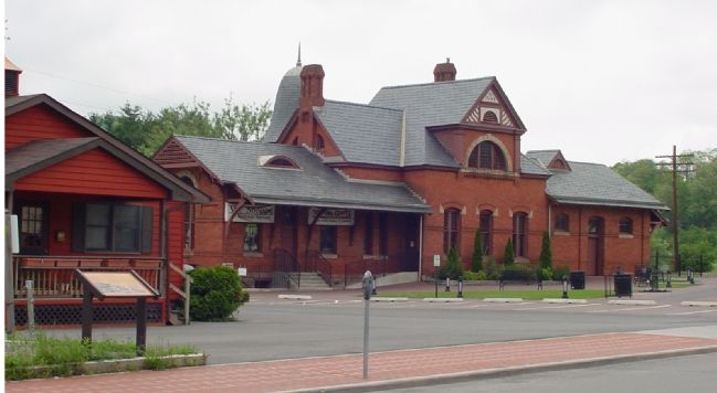
Passengers in the late 1800s would have instantly recognized this building as the Baltimore and Ohio (B&O) Railroad station. Known for their distinctive style and red-and-brown color scheme, the B&O designed their stations to give customers a . . . — — Map (db m70782) HM
The B&O Railroad constructed this embankment in the 1890s, covering a large section of the original armory site and elevating their train tracks above flood levels. — — Map (db m143945) HM
Built in 1826 as a private residence, this Federal style house was acquired by the War Department in 1837 and became U.S. Armory dwelling No. 55. Jefferson Davis signed the deed in 1852 when the government sold the house to Armory worker James . . . — — Map (db m148859) HM
Work on the railroad and canal progressed slowly at first, but by 1834 both companies had completed construction to a point opposite Harpers Ferry. The canal had won the race to this point and it continued up the Maryland side of the Potomac. . . . — — Map (db m12062) HM
Rail transportation in the United States began in Baltimore, Maryland on July 4, 1828, when Charles Carroll, the only living signer of the Declaration of Independence, laid the cornerstone of the Baltimore and Ohio Railroad.
On the same day . . . — — Map (db m12060) HM
Shepherdstown and Smithfield Turnpike Tollhouse/John Fox House
Immediately west of Rellim Farm is a mid-19th century log dwelling, and the only known surviving toll house on the old Shepherdstown and Smithfield Turnpike (previously Leetown . . . — — Map (db m148880) HM
This station structure was erected in 1839 by landowner Richard Duffield, in cooperation with the Baltimore & Ohio Railroad. It is the oldest surviving purpose-built freight/passenger rail station in the United States, and is listed on the . . . — — Map (db m157741) HM
The Federal offensive in the Shenandoah Valley begun in May 1864 faltered in the summer with Confederate victories and Gen. Jubal A. Early's Washington Raid in July. Union Gen. Philip H. Sheridan took command in August, defeated Early at . . . — — Map (db m206976) HM