375 entries match your criteria. The first 100 are listed. Next 100 ⊳
Covered Bridges Historical Markers
Wooden bridges were covered to protect the bridge flooring from the elements. It was more economical to re-roof a bridge than to replace the flooring. Concrete and Steel spans replaced covered bridges when they became cheaper to build.
By cmh2315fl via Flickr (CC BY-NC 2.0), June 12, 2011
Near Recreation Drive east of Mc Cullars Lane, on the left when traveling east.
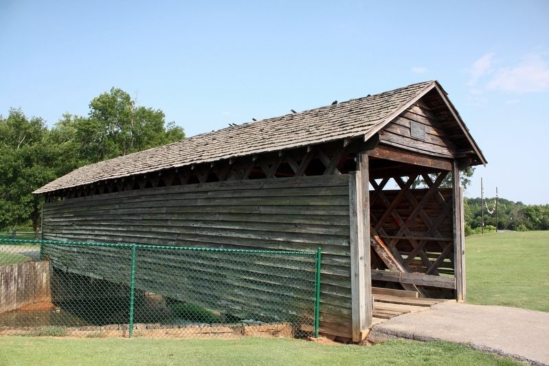
was moved on August 17 , 1990 to Oxford Lake
Leon Smith, Mayor
City of Oxford Councilmembers
Johnny Austin • Johnny Bentley • Bruce Dempsey
Norma Martin • Marshall Shaddix
The bridge was donated to the City of Oxford
by the . . . — — Map (db m198533) HM
This 270 foot bridge was constructed in 1904, destroyed by a flood in 1921 and rebuilt the following year. The only remaining covered bridge in Cullman County, it was restored by the Cullman County Commission in 1975 as an American Revolution . . . — — Map (db m33833) HM
On Park Road, 0.1 miles west of Rocky Brook Road, on the right when traveling west.
obverse
This is the last surviving covered bridge in Lee County. It was constructed about 1900 by Otto Puls over Wacoochee Creek in the Town's lattice truss design. Materials used in the 75 foot long bridge included longleaf heart pine, . . . — — Map (db m85337) HM
On Student Union Drive, 0.5 miles south of University Drive, on the right when traveling south.
1860 Captain W. A. C. Jones of Livingston designed and built the bridge of hand-hewn yellow pine put together with large pegs, clear span 88 feet, overhead clearance 14 feet, and inside width 17 feet, across the Sucarnoochee River on old State . . . — — Map (db m92661) HM
Near Horseshoe Bend Road (Alabama Route 49) 2.1 miles north of Freeman Road, on the left when traveling north.
Completed in 1908, the bridge was the first to span the Tallapoosa River between Dadeville and New Site. It was named in honor of Nora E. Miller, who owned the land upon which the bridge was located. Dadeville builder W. H. Wynn and his son, Will, . . . — — Map (db m223949) HM
(Front):Home Guard Defended Covered Bridge3 April 1865 - Brig Gen John T. Croxton’s Cavalry Brigade departed camp at Johnson’s Ferry (Old Lock 17 area) to the Watermelon Road ending in Northport. As the Union troops entered Northport, the . . . — — Map (db m35679) HM
On Pinedale Road, 0.5 miles south of Arizona Route 260, on the left when traveling south.
In recognition of her unselfish participation and example in community beautification. Serving on the town bicentennial committee, she proposed the covered bridge and the planting of pine trees along the lane north to the highway as being worth . . . — — Map (db m36665) HM
On Honey Run Road at Centerville Road, on the right when traveling north on Honey Run Road. Reported permanently removed.
Honey Run Bridge
Erected
1894
By George Miller
Gold Dredge
The first bucket line gold dredge to operate below the covered bridge used this tumbler – 1898. — — Map (db m29682) HM
Built in 1862 by David Isaac John Wood with lumber from his mill in Sierra County, this bridge was part of the Virginia Turnpike Company toll road which served the northern mines and the busy Nevada Comstock Lode. Utilizing a combination truss and . . . — — Map (db m8540) HM
This covered bridge across the South Fork of the Yuba River at Bridgeport, Nevada Co., Calif. was built by David I. Wood in 1862 with lumber from his mill in Plum Valley, Sierra Co., Calif. Erected by Columbia Parlor No. 70, N.D.G.W., French Corral, . . . — — Map (db m8528) HM
Bridgeport Bridge, or “Wood’s Crossing”, is the longest single span covered bridge in existence. Used since 1862, built by David I. Wood. This plaque is dedicated to those pioneer Americans who came to California in search of a new life . . . — — Map (db m8539) HM
Built in 1862 by David J. Wood with lumber from his mill in Sierra County, the covered bridge was part of the Virginia Turnpike Company toll road that served the northern mines and the Nevada Comstock Lode. The associated ranch and resources for . . . — — Map (db m78339) HM
Near Covered Bridge Road, 0.5 miles south of Graham Hill Road.
Built in 1892-93 and believed to be the tallest covered bridge in the country, it stood as the only entry to Felton for 45 years. In 1937 it was retired from active service to become a pedestrian bridge and figured prominently in many films of that . . . — — Map (db m2348) HM
Dedicated to the pioneer spirit of America
which bridges past, present and future
Designed in 1844 by Thomas Willis Pratt
Constructed 1969 by Roaring Camp & Big Trees
Narrow Guage RR. First Pratt-Truss covered bridge
built in . . . — — Map (db m190688) HM
On State Highway 120 at milepost 16.4 at Kennedy Road, on the left when traveling west on State Highway 120.
Picturesque mining center and trading post, 1849, once called Dentville. Early ferry to the southern mines; county seat 1862-72; rare wooden covered bridge reputedly designed by U. S. Grant, brother-in-law of the Dent brothers, 1854; old flour mill, . . . — — Map (db m178066) HM
Near Covered Bridge Road east of Sonora Road (Main Street), on the right when traveling east.
Knight's Ferry Bridge
has been designated a
National Historic Landmark
This property possesses national significance
in commemorating the history of the
United States of America Knight’s Ferry Bridge is an exceptionally fine . . . — — Map (db m146387) HM
On California Route 120, 0.3 miles east of Sonora Road, on the right when traveling west.
Picturesque mining center and trading post, 1849, once called Dentville. Early ferry to the southern mines; county seat 1862-72; rare wooden covered bridge reputedly designed by U. S. Grant, brother-in-law of the Dent brothers, 1854; old flour mill, . . . — — Map (db m178065) HM
On Roberts Ferry Road, 0.2 miles south of Yosemite Boulevard (California Highway 132).
[A short walk starting on the eastern side of the Roberts Ferry Covered Bridge; walking south, crossing over to the western side and returning north. Interpretive markers are placed along both sides covering the timeline from the first people who . . . — — Map (db m42617) HM
On Alleghany Ridge Road at Highway 49, on the right when traveling north on Alleghany Ridge Road.
In 1859 the rich Comstock Silver Lode was discovered in Washoe Territory, Nevada, causing many miners to quickly pack up and head east. Immediately a company was formed to construct a road connecting this area of California to the Comstock finds. . . . — — Map (db m65968) HM
Built in 1860, the Oregon Creek Covered Bridge was floated from its foundations by the flood waters from the breaking of English Dam in 1883. It was restored to place by using ox teams and log rollers, but turned end for end in the process. — — Map (db m65967) HM
On Colchester Avenue (Connecticut Route 16) at Browns Mill Road, on the right when traveling north on Colchester Avenue.
Comstock Covered Bridge
Built in 1873 by the Towns of Colchester and East Hampton
The Comstock Covered Bridge is one of only three historic covered bridges remaining in Connecticut. With a main span 80 feet in length (measured from the faces of . . . — — Map (db m84109) HM
On Barley Mill Road, on the right when traveling north.
Original Town Lattice Truss Covered Bridge – ca. 1850
Bridge Deck Rehabilitated – 1964
Listed on National Register of Historic Places – 1973
Complete Rehabilitation & Steel Beams Added – 1982
Rehabilitated Stone Foundation and
Replaced . . . — — Map (db m62043) HM
On Northwest 95th Avenue south of Wiles Road, on the left when traveling south.
The Covered Bridge was the first permanent structure built within the City by Coral Ridge Properties, developer of Coral Springs, in 1964. It withstood the eye of Hurricane Cleo that passed over it in August 1964 without sustaining any damage. The . . . — — Map (db m100391) HM
On East Broad Street east of First Street, on the right when traveling east.
You are standing at the historic terminus of Broad St. Through this iron gable - which represents an original wooden covered bridge to Cook & Brother Factory - you can view historic Downtown Athens. — — Map (db m195756) HM
Near East Broad Street east of Wilkerson Street, on the right.
Built around 1885, a wooden covered bridge connected the mill community of Potterytown to the Check Factory textile mill.
On this site the mill bridge brought East Broad Street to the front door of the mill. By 1909, this bridge was replaced . . . — — Map (db m207642) HM
On Hurricane Shoals Park Road, 0.1 miles south of Wheeler Cemetery Road, on the right when traveling south.
On this site in 1882, the original Hurricane Shoals Covered Bridge was completed, spanning some 127 feet at the cost of a mere $1,433. Vandals burned the old bridge in 1972, spoiling a community landmark and transportation corridor that had been in . . . — — Map (db m109855) HM
On Covered Bridge Road SW, 0.1 miles west of Covered Bridge-Stilesboro Road SW, on the right when traveling west.
In 1886 the county contracted with Washington W. King, son of freed slave and noted bridge builder Horace King, and Jonathan H. Burke for the construction of this 138-foot bridge. It was adjacent to a mill owned by Daniel Lowry, of which the . . . — — Map (db m8478) HM
On Bluff Street, 0 miles south of Commerce Street, on the right when traveling south.
Side 1:
The second covered bridge across the Chattahoochee River, connecting Clay County, Georgia and Henry County. Alabama was constructed between 1867-69. Bonner and Walden, a New York construction company, were the original contractors . . . — — Map (db m164123) HM
On Concord Road Southwest, 0.2 miles east of East-West Connector, on the right when traveling west.
The Concord Covered Bridge, constructed with the Queenpost design. was built in 1872 by Daniell and Ruff, who owned land and mills nearby. It replaced a bridge believed to have been built in the 1840's and destroyed during the Civil War. The Concord . . . — — Map (db m197630) HM
"Covered bridges" or "lattice bridges" were
common throughout the Eastern U.S, during the
nineteenth century. This bridge formerly
spanned the North Fork of the Oconee River in
the city of Athens, Ga.. connecting College
Avenue and Hobson . . . — — Map (db m11054) HM
On Columbia Highway (Georgia Route 62) at Old River Road, on the right when traveling west on Columbia Highway.
The covered bridge over Coheelee Creek, two miles north on the Old River Road, was ordered built by the Early County Board of Commissioners in 1883. It was erected by J. M. Baughman. Commissioners were J. S. Moseley, W. C. Sheffield, H. C. Fryer, . . . — — Map (db m48327) HM
On Old River Road at Fanny Askew Williams Park Entrance, on the left when traveling north on Old River Road.
The construction of this 121-foot bridge at McDonald’s Ford was first authorized by the county in 1883, though construction was delayed until 1891. It was completed in four months by J.W. Baughman and thirty-six workers as a modification of the . . . — — Map (db m14850) HM
Coheelee Creek Covered Bridge
According to the May 2, 1883 minutes of the Early County Board of Commissioners, a commission was appointed "to inquire into the practicability of construction a bridge across Coheelee Creek at McDonald Ford." . . . — — Map (db m8503) HM
Near Old Poole's Mill Road, 0.2 miles north of Heardsville Circle, on the right when traveling south.
Cherokee Chief George Welch constructed a grist mill here on his extensive homeplace c. 1820. An uncovered bridge was later added. With the 1838 removal of the Cherokees, the land was sold to Jacob Scudder. Dr. M. L. Pool purchased it from Scudder's . . . — — Map (db m14944) HM
On Baker Road, 0.1 miles north of Athens Road (Georgia Route 106), on the right.
The Cromers settled on Nails Creek in Franklin County in 1845. Prior to the Civil War, the family operated a woolen mill near this site. Subsequently, the area maintained a cotton gin, flour mill and saw mill, though all operations had ceased by . . . — — Map (db m14932) HM
Near Mill Street, 0.3 miles east of Atlanta Street, on the right when traveling south.
Now named Big Creek, this waterway was historically known as Vickery Creek. The creek was named for Charlotte Vickery, a Cherokee woman, who owned a farm along the creek’s headwaters in Forsyth County during the 1830s.
For over 140 years, the . . . — — Map (db m227973) HM
On Covered Bridge Road, 0.2 miles east of Dan Stribling Road, on the right when traveling north.
This bridge was built in the 1840s by freed slave and noted bridge builder Horace King (1807-1885). Constructed on the Town lattice design, the bridge’s web of planks crisscrossing at 45- to 60-degree angles are fastened at each intersection with a . . . — — Map (db m57329) HM
On Chattahoochee Riverwalk, on the left when traveling south.
Horace King Master Builder (1807-1887)Born a slave in Chesterfield District, S.C., Horace King came to Columbus in 1832 with his master, John Godwin, to construct the first bridge between Columbus and Girard, Alabama. After the completion . . . — — Map (db m113940) HM
On Elder Mill Road, 0.3 miles north of Saxon Road, on the right when traveling north.
Built in 1897 by Nathaniel Richardson, this 99-foot-long bridge originally carried the Watkinsville-Athens Road over Calls Creek. It was moved here to
Rose Creek in 1924 and the road was relocated to its present site. The nearby c. 1900 grist mill . . . — — Map (db m14945) HM
On Watson Mill Road at Whitsel Hollow Road, on the left when traveling west on Watson Mill Road.
Built by W.W. King in 1885, Watson Mill Bridge is Georgia’s longest existing covered bridge. Of the Town lattice type it has four spans and is 236 feet long.
Covered primarily to protect the structural timbers, the bridge served local traffic, . . . — — Map (db m47310) HM
Near Chandler Silver Road (County Route 311) at Smithonia Road.
Built in 1904-05 to replace an earlier structure, this bridge bears the name of a pioneer family who settled near Big Cloud’s Creek in the late 1700s. Constructed in the Town lattice design using convict labor, the 164-foot bridge’s web of planks . . . — — Map (db m8989) HM
On West Mulberry Street east of Douglas Street, on the left when traveling west.
Born a slave, Horace King became a master builder who constructed covered bridges over every large river between western Georgia and eastern Mississippi. King gained his freedom in 1846 through the Alabama legislature with the aid of his master, . . . — — Map (db m103136) HM
On Greenville Street at Horace King Street, on the right when traveling east on Greenville Street.
Born a slave September 8, 1807, Horace King became a noted builder of covered bridges and public buildings. His talents developed under the instruction of his master and friend, John Godwin. In 1846, Godwin secured King’s freedom through the Alabama . . . — — Map (db m22254) HM
Near Allen Road, 0.2 miles west of Wilmot Mill Road, on the left when traveling east.
This bridge, 120 ft. long spanning 96 feet, was built in 1892 by the firm of Herring and Alford, using the town lattice construction. Its cost of $1,199 was funded by the Upson County Commission. It is the last remaining covered bridge in Upson . . . — — Map (db m115881) HM
On Georgia Route 255, 3 miles Georgia Route 17, on the right when traveling north.
Fred Dover constructed a bridge and nearby grist, saw and shingle mill complex here in the late 1800s. The original bridge washed away in the early 1890s and Will Pardue replaced it in 1895 with the present 38-foot structure. Dover sold the . . . — — Map (db m8984) HM
On Cumberland Road north of U.S. 40, on the right when traveling east.
[column 1:]
"History of The National Road"
Settlers had been moving west since the early 1700's. By 1802, so many farms and towns had been settled in the Ohio Valley that people living in the territory were calling for . . . — — Map (db m155631) HM
On Cumberland Road north of U.S. 40, on the right when traveling east.
Historic Bridge Re-Created
177 years after the original Jackson Covered Bridge was constructed on this site a new bridge now spans the Embarass River. This structure re-creates as an original covered timber bridge that once stood on this . . . — — Map (db m152477) HM
On Cumberland Road north of U.S. 40, on the right when traveling east.
[column 1:]
1830 - Original Jackson Truss Bridge
Excerpts from inspection report made in 1833:
[Doc. No. 117] 23d Congress, 1st Session, HO. Of Reps. War Dept.
May 14, 1834
"Inspection Cumberland Road and its . . . — — Map (db m155370) HM
On Cumberland Road, 0.9 miles west of Mill Road, on the right when traveling east.
November - December - 1998
Removal of Old Structure
Existing 1920 Concrete Tru-Truss Bridge.
October 26 - 1998 Closing Bridge & Preparing for Removal.
Old Structure is in poor condition. Pier footing is severely undermined. . . . — — Map (db m239838) HM
On Illinois Route 104 north of Dnr Road, on the right when traveling north.
The original covered bridge was built in the fall of 1866 by Jacob Allaman at a total cost of $2,125.00. The bridge carried traffic until 1934. In 1935 the Illinois Division of Highways acquired the bridge from Henderson County, and it became the . . . — — Map (db m181371) HM
Near Illinois Route 150, 0.2 miles south of Briarhill Road.
Built in 1854, in continuous service from 1854-1930. Was originally part of a planked toll road between Breman and Chester. All of the timber in the bridge is the original with the exceptions of the floor, floor joist, roof and siding. Acquired by . . . — — Map (db m161447) HM
On 1790 East west of 1740 East, on the right when traveling south.
The road on which this bridge is located was once an important route between Springfield and Effingham. The bridge was completed in the autumn of 1868 at a cost of $2,500 and named for the owner of the first mill near here. It is the narrowest of . . . — — Map (db m188395) HM
On County Road S75E north of Road E500S, on the left when traveling north.
In 1831 John Adams, Pennsylvania, built a saw mill here. In 1832 he entered land, in 1835-36 added a flouring mill. The present building was erected in 1845, restored by M. & Mrs. Claude Sheets in 1840. Boliver Village was platted around the mill in . . . — — Map (db m42694) HM
Near West North Washington Street just east of Charles Street, on the right when traveling east.
The Bicentennial Garden was created in 2016 as a way for the Carroll
County Wabash & Erie Canal Association to celebrate the two
hundredth anniversary of the founding of the state of Indiana. With
a strong focus on blues and yellows, the . . . — — Map (db m163258) HM
On South 500 West, 0.5 miles north of West 600 South, on the right when traveling north.
Built by the Wheelock Bridge Company of Fort Wayne, Indiana, in the year 1872. The bridge spans 128 feet over the Wildcat Creek and is supported by cast iron abutments. The abutment design was patented by Alpheus Wheelock in 1870. Replicated . . . — — Map (db m159988) HM
Built 1879
Original Design by Archibald M. Kennedy and Sons
Additional Structural Supports added in the early 1900s to sustain heavier loads produced by Guilford's rail commerce
Moved from Yorkridge Rd to park in 1960
Damaged by . . . — — Map (db m87947) HM
On W. Layton Drive north of County Road W1100S, on the right when traveling west.
A Single Span Burr Arch Bridge
Built by A.M. Kennedy & Sons in 1880
Clear Span 111 ft. 6 in. Overall Length 130 ft.
Entered on the
National Register of Historic Places
June 25, 1982 — — Map (db m73979) HM
On County Road 68 west of County Road 57, on the right when traveling west.
Built 1873, by John A. McKay, spanning Saint Joseph River; a Smith Truss, Variant Four, by Smith Bridge Company, Toledo, Ohio; has remained in use with regular maintenance, repairs, and extensive 1981 restoration. Listed in National Register of . . . — — Map (db m52971) HM
Near Park Road (Indiana Route 1) just south of East 28th Street, on the right when traveling north.
The Kennedy Family
Emmett Loren Kennedy was born July 5, 1848. I 1870, he worked for his father, Archibald M. Kennedy, on the first bridge built by the Kennedy family. Upon completion of this bridge at Dunlapsville, in Union County, Indiana, . . . — — Map (db m152015) HM
On Pennington Road at Whitewater Canal Trail, on the right when traveling east on Pennington Road.
The Whitewater Canal Trail follows
a 2.6 mile "water level route" so it is
basically level. It has a solid surface
made of crushed stone, and it is
suitable for walking or bicycling. The
route travels along farm fields and
through a . . . — — Map (db m163370) HM
On Snow Hill Road, 0.1 miles west of Johnson Fork Road, on the right when traveling west.
(Front Side)
Built 1894-1895 over Johnson's Fork Creek by John H. Horn and William H. Butts to a Howe truss design by John Burkhart. All men were local residents. Bridge was important passageway to Cincinnati markets. Rests on stone . . . — — Map (db m66868) HM
On 4th Street south of High Street, on the right when traveling east.
Built at New Cumberland in 1877 by William Parks of Marion at a cost of $722. The 1913 flood floated the bridge a half mile downstream. It was returned to its foundations by rollers and horsepower. New Cumberland was the second community in Grant . . . — — Map (db m7479) HM
Near 3rd Street at Front Street, on the right when traveling north.
The Cumberland Covered Bridge was built in 1877. During the Great Flood of 1913, it was washed downstream.
On March 26th 1913, the Mississinewa River floodwaters rose high enough (Fig. 2, 3) to push the Cumberland Covered Bridge from its . . . — — Map (db m71494) HM
On North 3rd Street (County Road 1000E) at Front Street, on the left when traveling north on North 3rd Street.
This covered bridge
built 1877 – 181 ft. long
called Cumberland Bridge
for Old Town.
The 1913 flood carried the bridge
downstream. It was returned
on rollers to the old foundation
and raised 3 feet.
The 1958 flood . . . — — Map (db m214996) HM
On S. Baseline Road (County Road 25 E) 1.2 miles north of County Road 300 S, on the left when traveling north.
Built 1883 by A.M. Kennedy and Sons to Burr arch truss design on stone abutments. Closed 1957; opened 1967 after foundation and roof rehabilitation; closed 1990. Bridge reopened 1998 following extensive structural renovation and replacement of . . . — — Map (db m98962) HM
On Allisonville Road, on the right when traveling west.
First bridge spanning White River at Potter's Ford was commissioned 1860 and named after the landowner, William Potter. In 1870, Hamilton County Commissioners voted for construction of this "Howe Truss" bridge. It was finished 1871 and . . . — — Map (db m8165) HM
On Allisonville Avenue at Covered Bridge Way, on the right when traveling west on Allisonville Avenue.
Potter's Bridge was built in 1871 by Josiah Durfee of Noblesville for a mere $13,000. It connects the land called "Potter's Ford,” named for William A. Potter (1838-1883) who owned and farmed the surrounding land.
Why Were Bridges . . . — — Map (db m163077) HM
The Medora Bridge
The Medora Covered Bridge was built in 1875 by noted timber bridge builder J.J. Daniels. It was built to carry local traffic across the East Fork of the White River forty years before there was a state highway system. . . . — — Map (db m74047) HM
Built in 1876 by J.J. Daniels
Burr Arch
Length 331 Ft. + 12 Ft. overhang/ends.
Width 16 ft. height 12ft.6in.
Cut stone abutments and pier. — — Map (db m39335) HM
Near North Blackford Street north of Indianapolis Cultural Trail, on the right when traveling north.
Parke County has preserved the majority of its covered bridges, many of them dating back to the 1800s, and boasts more than any other county in the nation. Life in the early communities centered around the mills established along Sugar Creek, Big . . . — — Map (db m238843) HM
On County Road E 500N at County Road N 575E, on the right when traveling east on County Road E 500N. Reported missing.
Local donations helped build this important transportation link. Completed 1868; closed to vehicular traffic, 1976. Listed in National Register of Historic Places, 1990. Approximately 166 feet long; Howe Truss design; built of oak and poplar with . . . — — Map (db m69392) HM
Near N. Cataract Road at Owen Park Road, on the right when traveling west.
(Side One)
An 1838 state law gave county commissioners power to build bridges for “public convenience” and to raise taxes to pay for them. Owen County Commissioners contracted 1875 for a “Smith’s High Double Wood . . . — — Map (db m74181) HM
The Cataract Covered Bridge is one of Owen County’s historic treasures. It is the only remaining covered bridge in the county. It is also only one of six Smith Truss covered bridges in the state, and one of the finest remaining examples of this . . . — — Map (db m74182) HM
On Cox Ford Road, 0.2 miles U.S. 41, on the left when traveling east.
Burr Arch construction by Wm. Hendricks. 102' in length, crosses Sugar Mill Creek and was named for a mill that formerly stood nearby. — — Map (db m159708) HM
On County Road 100 N east of Adams Road (County Road 349), on the right when traveling east.
The State Sanatorium Covered Bridge is a single-span Kingpost Truss Burr Arch structure with a span length of 154 feet. It was constructed in 1913 by Joseph A. Britton. The bridge is listed on both the National Register of Historic . . . — — Map (db m164851) HM
On East Ohio Street (U.S. 36) at Constitution Street on East Ohio Street.
This 1883 Railroad Depot serves as Parke County's Tourist Information Center. All covered bridge tours begin here.
Indiana's Historic Parke County The Covered Bridge Capital — — Map (db m3675) HM
On County Road S325W north of County Road S550W, on the right when traveling north.
The first business in Parke County was a grist mill built near here by Chauncey Rose and associates in 1819.
This was the first flatboat landing in the county; territorial court was held here and this was a stop for stagecoaches. — — Map (db m164853) HM
On County Road E 650N at Saddle Club Road, on the right when traveling east on County Road E 650N.
Built 1856 by Henry Wolfe to Burr arch truss design. Moved here 1961 to replace Dooley Station Bridge. Restored and reopened 1996. Horizontal yellow poplar siding replaced with pine; oak arches; new cedar shingles; concrete abutments. Listed in . . . — — Map (db m69399) HM
This bridge is also known as the Baker's Camp Covered Bridge. It was constructed in 1901 by J.J. Daniels over Big Walnut Creek. It is a single span and measures 128 feet long, 14 feet wide and stands 13 feet high. A short distance to the north is . . . — — Map (db m6428) HM
Huffman Mill Bridge 1864-65 William T. Washer was contracted with Spencer & Perry Counties, July 1864 to build a 148 foot yellow poplar Burr Arch-Trust Bridge. (Patented by Theodore Burr 1771-1882). Contract payment called for Ten Thousand . . . — — Map (db m56774) HM
County commissioners ordered (1873) to replace unsafe bridge over Big Vermillion River at Eugene. Built 1873 by Joseph J. Daniels, Rockville: Burr truss design, 180 foot span, using existing abutments. Closed to vehicle traffic, 1974. Listed in . . . — — Map (db m3701) HM
On County Road 50 (AKA: Hopkins Street), 0.6 miles State Road 63, on the right when traveling west.
County commissioners ordered (1885) as link across Little Vermillion River at Newport & Quaker Point Free Gravel Road. Built 1885 by Joseph J. Daniels, Rockville: Burr truss design, 180 foot span, sandstone abutments. Floor replaced, 1984. Listed in . . . — — Map (db m3699) HM
On Cedar Bridge Road, 1.8 miles north of Iowa Highway 92, on the left when traveling north.
Original Built: 1883
By: H.P. Jones
Replica Built: 2004
By: Herberger Construction Company
Type: Covered Timber Town Lattice Truss
Overlaid by a Queenpost Frame
Size: 130 feet (66 ft truss with an 42.5 ft approach to the south
and a . . . — — Map (db m78220) HM
On South 9th Street, on the right when traveling south.
Designed and built by Eli Cox.
Length: 79 feet Weight: 40 ton.
Covered timber superstructure, towne lattice truss
with overlay queenpost frame, fastened with round
wooden pins and iron bolts.
Originally located 18 miles N.E. of . . . — — Map (db m23170) HM
On Hogback Bridge Road, on the left when traveling north.
Built: 1884
By: Benton Jones
Type: Covered Timber Town Lattice Truss
overlaid by a Queenpost Frame
Size: 160 feet (98 ft truss with two 62 ft
approaches) x 15 feet wide
Jones was responsible for the last all-timber truss built in the . . . — — Map (db m72410) HM
On Holliwell Bridge Road, on the right when traveling east.
[Historical excerpts from marker]
The Middle River has its origin in south-central Guthrie County. However, the navigable section of Middle River begins in east-central Adair County near Middle River Forest County Park. Middle River is a . . . — — Map (db m72408) HM
On Elderberry Avenue south of Roseman Bridge Road, on the right when traveling south.
[Historical excerpts from marker]
The Middle River has its origin in south-central Guthrie County. However, the navigable section of Middle River begins in east-central Adair County near Middle River Forest County Park. Middle River is a . . . — — Map (db m72439) HM
On Elderberry Avenue south of Roseman Bridge Road, on the right when traveling south.
Built: 1883
By: Benton Jones & G.K. Foster
Type: Covered Timber Town Lattice Truss
overlaid by a Queenpost Frame
Size: 225 feet (104 ft truss with an 88 ft
approach to the south and a 33 ft approach
to the north) x 15.4 feet wide . . . — — Map (db m72438) HM
The Owen's Covered Bridge was built around 1875 to span the North River, a tributary of the Des Moines River. This Howe Truss style bridge originally sat about 2.5 miles northeast of Carlisle where it formed part of a road from Martins Ferry to . . . — — Map (db m236539) HM
On Colville Road (Kentucky Route 3118) north of Endicott Lane, on the right when traveling north.
Colville Covered Bridge Built in 1877, this bridge spans Hinkston Creek. It is of Burr truss construction, which is the multiple king post type. The single span is 124 feet long and 18 feet wide. It was restored by Louis Bower in 1913 and by . . . — — Map (db m171786) HM
On Woolcott Road, 0.1 miles east of Wellsburg Walcott Road (Kentucky Route 1159) when traveling east.
Walcott Covered Bridge This scenic bridge, also known as The White Bridge, is a 75-foot span over Locust Creek and has served Walcott community from 1824-1954. It is of King and Queen type, timber truss construction with hand-hewn joints and . . . — — Map (db m217818) HM
On Kentucky Route 111 at City Road, on the left when traveling north on State Route 111.
Built circa 1868-70, this bridge is a single 86 ft. span and a good example of Theodore Burr’s truss employing multiple king posts. The yellow pine timbers have double-shouldered braces. Abutments are of “red stone”; corrugated sheet . . . — — Map (db m146743) HM
On Ringos Mills Road (Kentucky Route 158) at Rawlings Road, on the left when traveling east on Ringos Mills Road.
This bridge and the surrounding
community developed because of a
grist mill operating on Fox Creek
in the mid 1800s. The single span
structure is 86 ft. long and built,
1867, on popular Burr truss design.
The original yellow pine . . . — — Map (db m146825) HM
On Morehead Road (Kentucky Route 32) at Covered Bridge Road on Morehead Road.
Goddard “White” Bridge
This covered bridge is the only surviving example of Ithiel Town Lattice design in Ky. The timbers are joined with wooden pegs (tree-nails); its date of construction and original builder are unknown. The . . . — — Map (db m83626) HM
On Wilkinson Boulevard, on the right when traveling south.
Look across the river toward
Benson Creek and you will see
two bridges. Both are steel span
bridges, and both share one
common aspect - they are
supported by dry-laid
abutments.
Many bridges across Kentucky,
including covered bridges . . . — — Map (db m194222) HM
375 entries matched your criteria. The first 100 are listed above. Next 100 ⊳