On Blairfield Drive, on the right when traveling east.
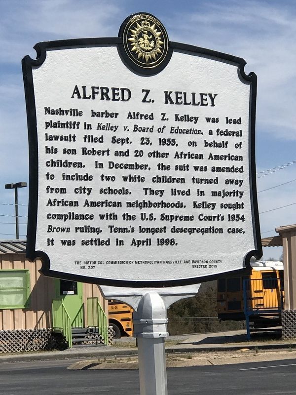
Nashville barber Alfred Z. Kelley was lead
plaintiff in Kelley v. Board of Education, a federal lawsuit filed Sept. 23. 1955, on behalf of his son Robert and 20 other African American
children. In December, the suit was amended
to include two . . . — — Map (db m146420) HM
On Antioch Pike, 0.1 miles north of Goodwin Road, on the right when traveling north. Reported missing.
The Mill Creek Valley Turnpike Company was incorporated by the Tenn. Gen. Assembly on Jan. 21, 1846. Starting near the four mile mark of Nolensville Pike, the road went through Mill Creek valley, "crossing main Mill creek at or near Rains' mills, . . . — — Map (db m220577) HM
On Old Hickory Boulevard, 0.1 miles east of Cane Ridge Road, on the right when traveling west.
Cane Ridge Cumberland Presbyterian Church, built in 1859, replaced a log building which occupied land donated by Edwin Austin & Thomas Boaz in 1826. One of the best known pastors was Hugh Bone Hill who also preached at the Jerusalem Church in . . . — — Map (db m146619) HM
On Reeves Road, 0.1 miles east of McBride Road, on the left when traveling east.
Located near Mill Creek, Locust Hill is one of the earliest brick homes in Middle Tennessee. Built c. 1805, it was home to the Charles Hays family until after the Civil War. The Federal-style house features intricately carved mantles and millwork, . . . — — Map (db m147404) HM
On Cane Ridge Road, 0.4 miles north of Old Hickory Boulevard, on the right when traveling north.
In 1871, District 6 school commissioners John Briley, Benjiah Gray and Jason Austin bought one acre of land from James Thompson for an African American school. In 1873, African American members of the Benevolent Society of Olive Branch No. 38 . . . — — Map (db m147704) HM
On McGavock Pike at Stones River Road, on the left when traveling north on McGavock Pike.
Built in 1859 by David H. McGavock, this mansion stands on land inherited by McGavock's wife, Willie, from her father, William Harding. The smaller house to the left was built in 1802. Dr. James Priestley's Academy, established about 1816, was . . . — — Map (db m147569) HM
Built in 1858 by Dr. James Hoggatt on land inherited from his father, Capt. John Hoggatt, a Revolutionary War soldier, this fine Italian villa style home is centered in an area of local historical significance. John Donelson settled early in this . . . — — Map (db m147571) HM
On 5th Avenue North at Madison Street, on the right when traveling north on 5th Avenue North.
Germantown was home to many 19th-cen. European immigrants who brought their trade skills to Nashville, including brewing. By 1865 Germantown was home to 4 breweries: North Nashville Brewery (C. Kreig); Rock City Brewery (F. Kuhn); Cumberland Brewery . . . — — Map (db m163414) HM
On Long Hollow Pike (Tennessee Route 174), on the right when traveling east.
Here on west bank of the creek that he discovered in 1772, Kasper Mansker and other first settlers built a log fort in 1779. John Donelson’s family fled here in 1780 for safety from Indians. Mansker abandoned the fort in 1781 and moved to Fort . . . — — Map (db m2586) HM
On Nella Drive, 0.1 miles west of Green Acres Drive, on the left when traveling west.
This is the "dream house" of country music icon Patsy Cline, born Virginia Patterson Hensley in 1932. Roy Acuff offered her a job by the age of 16, but she opted to sing with a local group back home in Winchester, Va. She changed her name in 1953 . . . — — Map (db m146002) HM
On Shute Lane at Lebanon Pike (U.S. 70), on the left when traveling north on Shute Lane.
In 1921 the State rented land west of Shute Lane and erected two hangars here for the 105th Observation Squadron, Tennessee National Guard. The airfield of about 100 acres was named for H. O. Blackwood, who gave $1,000 to aid the project. The first . . . — — Map (db m147683) HM
On Chandler Road, 0.1 miles north of Summit Run Place, on the right when traveling north.
As early as 1815, school was held nearby at Stoner's Lick Methodist Church. In 1843, early settler Timothy Dodson granted land for a dedicated schoolhouse that was built c. 1855. After it burned, classes were held at the Hermitage railroad station . . . — — Map (db m147673) HM
On Morgan Road, 0.6 miles east of Whites Creek Pike (U.S. 431), on the left when traveling east.
Named for the Paradise brothers, early settlers from North Carolina, this ridge was home to the Joelton Air Force Station from 1956-61, when the 799th Aircraft Control and Warning Squadron operated here as a part of the integrated continental . . . — — Map (db m147786) HM
On Hospital Drive, 0.1 miles north of Neelys Bend Road, on the left when traveling north.
Madison College was founded in 1904 as Nashville Agricultural Normal Institute by Seventh-day Adventists on a farm of 412 acres. A sanitarium and campus industries were integral to the plan of work and study for students training for careers in . . . — — Map (db m147701) HM
On Gallatin Pike North (U.S. 31E) at Rivergate Parkway, on the right when traveling south on Gallatin Pike North.
After Col. John Donelson was killed in 1785, his widow and family continued to live here in a log house. In 1789 lawyers Andrew Jackson and John Overton boarded with the Donelsons. Here Jackson met Rachel, the Donelson's youngest daughter. They . . . — — Map (db m147702) HM
On Neelys Bend Road just north of Nix Pass, on the right when traveling north.
In 1943, with a $1000 loan from a friend, Douglas G. Odom, Sr., his wife Louise, and their children - Doug Jr., Richard, Judy, and June - started a four-hog a day sausage business. Before selling the company in 2012, the three generation . . . — — Map (db m147698) HM
On Gibson Drive, 0.2 miles north of Due West Avenue, on the left when traveling north.
This stone, Monterey-style house was built in 1925 and purchased in 1952 by “Mr. Country,” Carl Smith, just weeks before his marriage to June Carter, of the famed Carter Family. The farm remained home to June and daughter Carlene . . . — — Map (db m147478) HM
On Tyne Boulevard, on the right when traveling east.
After the withdrawal from the main Confederate line at Peach Orchard Hill, Lt. Gen. Stephen D. Lee formed a battle line across Franklin Pike 400 yards east of here with 200 men from the remnants of Brig. Gen. Henry Clayton's division and two cannons . . . — — Map (db m53394) HM
On Elm Hill Pike west of Massman Drive, on the right when traveling east.
Arthur Redmond, a European brewer who immigrated to Nashville in 1815, established a brewery and bakery on Chicken Pike, now Elm Hill Pike. Situated along the east side of Mill Creek near Foster's and Buchanan's mills, he brewed porter and ale and . . . — — Map (db m151769) HM
On Centennial Boulevard at Bomar Boulevard, on the right when traveling north on Centennial Boulevard.
In 1786, the State of N.C. granted Gen. James Robertson several large tracts of land in this area. Robertson's Bend was renamed after the Cockrill family who established several farms and a mill here before the Civil War. The Romanesque-style third . . . — — Map (db m147820) HM
On Donelson Pike (State Highway 255) at Ezell Road, on the right when traveling north on Donelson Pike.
In 1805 Jeremiah Ezell (1775-1838) moved here from Virginia and purchased 17 acres of land on Mill Creek. In 1816 he served on the Court of Pleas for Davidson County. In 1888, his grandson, Henry Clay Ezell, built this brick vernacular Queen Anne . . . — — Map (db m147166) HM
On Post Road at Davidson Road, on the right when traveling south on Post Road.
In 1910, Horace Greeley Hill, Sr. and wife Mamie began buying land around their West Nashville home Cliff Lawn. After Hill Sr., an entrepreneur and philanthropist, died in 1942, H.G. Hill, Jr. took over the family business and began developing that . . . — — Map (db m147414) HM
On Nolensville Pike (Alternate U.S. 31) at Winston Avenue West, on the right when traveling south on Nolensville Pike.
Soon after the Civil War, freed slave families established farms and dairies in this community named for Lake Providence Missionary Baptist Church. The church was
founded in 1868 by Rev. Larry A. Thompson, a traveling missionary. The first church . . . — — Map (db m147128) HM
Luke Lea (1879-1945) envisioned this park, gave to the city in 1927 the original 868 acres, and asked that the land be named for his father-in-law, Percy Warner. Founder of the Nashville Tennessean, Lea was a key developer of Belle Meade, a U.S. . . . — — Map (db m68993) HM WM
On Hill Road at Granbery Park Drive, on the left when traveling west on Hill Road.
Revolutionary War Pvt. John Alford built a two-room house on this land c. 1810, expanding it in 1812 and 1820. The Alford cemetery retains three markers that were placed as early as 1822. The c. 1830 brick two-story Federal dwelling was home to . . . — — Map (db m147408) HM
Percy Warner (1861-1927) was a pioneer in electric utilities and hydroelectric development in the South. As chairman of the Park Board, he expanded Nashville’s park system. Preservation of this natural area was one of his greatest civic projects. . . . — — Map (db m68992) HM
On Murfreesboro Pike (U.S. 41) at Dell Parkway, on the right when traveling south on Murfreesboro Pike.
In 1832, the Tenn. legislature approved the state's first asylum, established in 1840 southwest of Nashville. The State bought this land in 1848, after activist-reformer Dorothea Dix and asylum staff called for improved facilities. Prominent . . . — — Map (db m147132) HM
On Air Freight Boulevard at Vultee Boulevard, on the right when traveling north on Air Freight Boulevard.
In 1858 P. & N. Harsh built a small brewery near Franklin College on Stones River Pike. E.D. Crossman & M.J. Drucker took over in 1860, renaming it the Tennessee Brewery. After fire destroyed it in 1860 and again in 1864, Drucker rebuilt it as . . . — — Map (db m194919) HM
On Crossings Boulevard west of Mt. View Road, on the right when traveling west.
Alice Thompson (1777-1828) married Revolutionary War veteran Edward Collinsworth (1759-1816) in Dec. 1795, after spending two years as a captive at the Muscogee (Creek) tribal town Kialegee, in present-day Alabama. Alice and Edward reared seven . . . — — Map (db m207153) HM
On Union Street at 5th Avenue, on the left when traveling north on Union Street.
On October 7, 1915, Dr. George Curtis, Albert F. Ganier, Judge H.Y. Hughes, Dr. George R. Mayfield, Dixon Merritt, and A.C. Webb met at Faucon's Restaurant, 419 Union Street, approximately 50 feet east of here, to found the Tennessee Ornithological . . . — — Map (db m61939) HM
On Windsor Drive at Blackburn Avenue, on the left when traveling west on Windsor Drive.
Platted in 1915 by developer Johnson Bransford. Belle Meade Golf Links is one of the early subdivisions that arose from the dissolution of the world-famous Belle Meade Plantation. This small residential district represents early 20th century . . . — — Map (db m147106) HM
On Leake Avenue at Park Hill Drive, on the right when traveling west on Leake Avenue.
In 1927 8.25 acres of the Belle Meade Plantation were acquired from its owner Walter O. Parmer to use for a new school. Parmer School opened that fall as a one-room school with grades 1-3. In 1928 the school was transformed into a modern brick . . . — — Map (db m147103) HM
On Gower Road, 0.1 miles north of Hickory Trail Drive, on the right when traveling north.
Centenary United Methodist Church
Rev. William Gower built the first Gower's Chapel on his farm in 1805. A larger chapel, erected in 1850 on Gower land, also served as the local schoolhouse. On Oct. 5, 1884, the newly named Centenary Methodist . . . — — Map (db m147425) HM
Near Tennessee Route 100, 0.4 miles west of Old Hickory Road (Tennessee Highway 254), on the left when traveling west.
Edwin Warner (1870-1945) succeeded his brother Percy on the Park Board in 1927 and served for eighteen years. He personally directed the acquisition of most of the Warner Park acreage and supervised WPA development of the property. Warner organized . . . — — Map (db m147109) HM
On U.S. 70S at Brookmont Terrace, on the right when traveling west on U.S. 70S.
In 1910, H.G. Hill, Sr. purchased this 324 acres including an old-growth forest west of downtown Nashville. He refused to allow the trees to be sold for timber and fenced the forest to keep his cattle from damaging the centuries-old trees. Hill . . . — — Map (db m147416) HM
On Myhr Green at Bradford Green, on the right when traveling south on Myhr Green.
In 1906, Norwegian-born Andres Ivarson Myhr and wife Minnie Bolton Myhr acquired land from Tabitha DeMoss and built "Maple Row," named for trees planted along the driveway. Part of Myhr Farm, this was the first house in Bellevue to have indoor . . . — — Map (db m147420) HM
Home of Mary Benton, widow of Jesse Benton who left Nashville after a famous feud with Andrew Jackson in 1813. The Greek Revival house was built c. 1852 and stood between Union and Confederate lines during the Battle of Nashville in 1864. Prominent . . . — — Map (db m52851) HM
On Benton Smith Road, on the right when traveling south.
On this hill was fought the decisive encounter of the Battle of Nashville December 16, 1864. At 4:15 P.M. a Federal assault at the angle on top of the hill broke the Confederate line. Col. W. M. Shy 20th Tenn. Inf. was killed and Gen. T. B. Smith . . . — — Map (db m53393) HM
On Harding Road (U.S. 70S) at Cherokee Road, on the right when traveling east on Harding Road.
Formally established in 1867 with a bequest of $20,000 by ironmaster Montgomery Bell, the roots of M.B.A. actually go back to 1785, with the University of Nashville, Cumberland College, and Davidson Academy. The boy's preparatory school has been . . . — — Map (db m147170) HM
On 3rd Avenue South south of Chestnut Street, on the right when traveling south.
Originally known as Chestnut Street Park, land
for this South Nashville park was purchased in
1913. That same year, two daughters of Parks
Commission chairman Robert M. Dudley — Louise
and Rebecca — died in a train accident in . . . — — Map (db m171873) HM
Erected in 1890 and named for Ireland's patron saint, this Second Empire style church was built to serve South Nashville's growing Irish Catholic population. Until 1954, the Sisters of Mercy taught a grade school here. Since the 1890s, the Irish . . . — — Map (db m74367) HM
On Hogan Road, 0.1 miles east of Trousdale Drive, on the left when traveling east.
The Crieve Hall neighborhood was part of the over 2,000-acre estate of John Overton, on which he built Travellers Rest in 1799. Jesse M. Overton built an English Tudor-style house called Overton Hall near here in 1900. Mr. and Mrs. Herbert Farrell . . . — — Map (db m147409) HM
On Elm Hill Pike at Hurt Drive, on the right when traveling west on Elm Hill Pike.
James Buchanan (1763-1841) built this two-story single pen log house with hall and parlor plan c1807. The single pen log addition was added c1820 to accommodate the Buchanan family's sixteen children. The house displays a high level of craftsmanship . . . — — Map (db m147565) HM
On Lebanon Road (U.S. 70) at Cottage Lane, on the right when traveling west on Lebanon Road.
In 1786, the State of North Carolina deeded this land as part of a 640 acre grant to Revolutionary War Private and land surveyor James Mulherin. The c. 1920 stone American Foursquare dwelling was home to Gilbert Stroud Logue and Emma McEwan Logue. . . . — — Map (db m147568) HM
On U.S. 431 just north of Commerce Street, on the right when traveling north.
Berger Building
In 1926, Samuel W. Berger hired local architect
Ozrow J. Billis to design this stylish building
outfitted with colorful glazed terra cotta
tiles. Berger was a Hungarian immigrant
and one of the city's leading retail . . . — — Map (db m183243) HM
On Charlotte Avenue at McLemore Avenue, on the right when traveling west on Charlotte Avenue.
1. First Baptist Church, Capitol Hill (1848) 2. Gay Street Christian Church (1859) 3. Mount Olive Missionary Baptist Church (1887) 4. St. Andrews Presbyterian Church (1898) 5. St. John AME Church (1863) 6. Spruce Street Baptist Church (1848) These . . . — — Map (db m147484) HM
On Church Street at Anne Dallas Dudley Boulevard, on the left when traveling east on Church Street.
The Nashville Equal Suffrage League was formed nearby in 1911 at the former Tulane
Hotel. In coordination with the Tennessee Equal Suffrage Association the energetic
efforts of women leaders influenced public opinion in the decade ahead. . . . — — Map (db m163927) HM
Front Organized in 1829, Christ Church was Nashville's first Episcopal parish. The present Victorian Gothic church designed by Francis Hatch Kimball of New York, opened for service on Dec. 16, 1894; the tower , by local architect Russell E. . . . — — Map (db m220816) HM
On Union Street at 2nd Avenue North, on the right when traveling west on Union Street.
William J. Gerst opened Gerst House restaurant in 1955, a year after the Wm. Gerst
Brewing Co. closed. Serving German-American food, it was a gathering place for attorneys, journalists and politicians due to its proximity to the courthouse. Bill . . . — — Map (db m193678) HM
On Commerce Street just west of St. Cloud Alley, on the left when traveling west.
John Robert Lewis was born on Feb. 21, 1940 to sharecropper parents in Troy, Ala. He
entered Nashville's American Baptist Theological Seminary in 1957 and soon began attending non-violence workshops at Clark Memorial Methodist Church with the . . . — — Map (db m177650) HM
On Rosa Parks Blvd at Charlotte Avenue on Rosa Parks Blvd.
Formerly located at his site was First Baptist Church, Capitol Hill, headquarters of the 1960s Sit-In Movement, led by Rev. Kelly Miller Smith. Strategy sessions, non-violence workshops, mass meetings, victory celebrations, and administrative . . . — — Map (db m74333) HM
On Church Street at YMCA Way, on the right when traveling west on Church Street.
On May 18, 1875, members of several Nashville churches gathered at the Christian Church (138 Vine Street) after a religious revival meeting and organized the Nashville Young Men's Christian Association. Its first building, erected in 1886 on Church . . . — — Map (db m147487) HM
Nashville's first public school, Hume School, opened here Feb. 26, 1855. A three story brick building, the school employed 12 teachers and served all grades. In 1874 high school classes were moved to Fogg School built on adjoining corner lot. Named . . . — — Map (db m28468) HM
Distinguished poet, critic, novelist, and teacher. Born in Nashville; Hume~Fogg graduate 1931; Vanderbilt bachelor's and master's degrees.
Served in U.S. Army Air Corps in WWII. Wrote about losses of war and childhood innocence.
Poet Laureate . . . — — Map (db m147724) HM
On Nelson Merry Street at 10th Avenue North, on the right when traveling east on Nelson Merry Street.
The Reverend Nelson G. Merry, born enslaved in 1824 in Kentucky, was brought to Tennessee by his master. At age 16, Merry's widowed mistress willed him to the First Baptist Church. He was freed in 1845. Merry preached to the "colored" mission of . . . — — Map (db m147482) HM
On 2nd Avenue North, on the right when traveling north. Reported permanently removed.
Lardner Clark came from Philadelphia in the early 1780's with ten horses packed with piece goods, needles and pins. He established Nashville's first drygoods store by 1786, on a site 30 yards east. The building, which served as store, tavern and . . . — — Map (db m188934) HM
On Commerce Street just east of Rosa L. Parks Boulevard (U.S. 31), on the right when traveling east.
Warren Jett opened The Jungle, a restaurant and cocktail bar, at 715 Commerce Street in 1952. Next door, Juanita Brazier opened Juanita's Place, a beer bar, in 1956. By the early 1960s, both were known as the first gay bars in Nashville. Jett sold . . . — — Map (db m147731) HM
On 3rd Avenue North, on the right when traveling north.
The Seeing Eye, the world-famous dog guide training school, was incorporated in Nashville January 29, 1929, with headquarters in the Fourth and First National Bank Building at 315 Union St. Morris Frank, a 20-year-old blind man from Nashville, and . . . — — Map (db m61940) HM
On Deaderick Street at 3rd Avenue North, on the left when traveling east on Deaderick Street.
Site of electric street railway transfer station 1902-1940. Electric streetcar service began formally on April 30, 1889, replacing mule~drawn streetcars which had served the city since 1866. Final run for electric streetcars was February 2, 1941 on . . . — — Map (db m145827) HM
On Broadway at 10th Avenue, on the right when traveling east on Broadway.
Erected by Louisville and Nashville Terminal Company and dedicated Oct. 9, 1900, the Romanesque style building of Bowling Green limestone and Tennessee marble was designed by L&N Chief Engineer Richard Monfort. A monument to the grand days of rail . . . — — Map (db m127271) HM
On Commerce Street at 7th Avenue North, on the left when traveling east on Commerce Street.
Nashville's Jewish community began in the 1840s. Many early families were immigrants fleeing oppression in Germany, Russia, and Poland. Completed in 1876, the Vine Street Temple, with nine Byzantine domes was Nashville's first synagogue, for 80 . . . — — Map (db m147730) HM
On Capitol Boulevard at Union Street on Capitol Boulevard.
On August 18, 1920, Tennessee became the 36th state to ratify the 19th Amendment to the U.S. Constitution, thereby giving all American women the right to vote. After weeks of intense lobbying by national leaders, Tennessee passed the measure by one . . . — — Map (db m52369) HM
On Rosa L. Parks Boulevard (U.S. 31) south of Church Street, on the right when traveling south.
Ward's Seminary for Young Ladies, founded in 1865 by Dr. William E. Ward, stood at this
site many years. Ward, a graduate of Cumberland University in both law and divinity, died in 1887. The school was sold, but continued to operate as Ward's . . . — — Map (db m166495) HM
On North 1st Street north of Oldham Street, on the right when traveling north.
Nashville's worst disaster by fire occurred Wednesday, March 22, 1916. It began at 11:47 a.m. in the rear of Seagraves Planing Mill, 80 yards west, and was swept eastwardly by 44 to 51 mph gales. It was brought under control at 4:30 p.m. near So. . . . — — Map (db m147761) HM
On Titans Way at Victory Avenue, on the right when traveling south on Titans Way.
On Feb. 25, 1862, Nashville became the first Confederate state capital to fall to Federal forces. Two days prior, the 4th Ohio Vol. Cavalry arrived from Bowling Green, KY and set up pickets along the east bank of the river. Gen. D.C. Buell arrived . . . — — Map (db m147722) HM
On Shadow Lane, 0.1 miles north of Airpark Drive, on the right when traveling north.
Cornelia Fort (1919-43), Nashville's first woman flying instructor volunteer, Army's WAFS, WWII, was the first woman pilot to die on war duty in American history. "I am grateful that my one talent, flying, was useful to my country," she wrote . . . — — Map (db m147711) HM
On Main Street just east of North 6th Street, on the left when traveling east.
Founded in 1866 under the direction of Rev. Randall B. Vandavall, First Baptist Church East Nashville built this Classical Revival building between 1928 and 1931, during the height of Rev. W.S. Ellingson's career. Nashville artist Francis Euphemia . . . — — Map (db m145790) HM
On Ann Street at Rock City Street, on the right when traveling west on Ann Street.
Rock City was an African American community established c. 1881, which was soon followed by the founding of First Baptist Church Rock City. Named for a rock quarry in the area, the approx. boundaries were Cahal Ave. to the south, Branch St. to the . . . — — Map (db m147714) HM
On Greenwood Avenue, 0.1 miles west of Scott Avenue, on the right when traveling west.
Eastland
The Eastwood area, a suburb originally named Eastland in 1901, was laid out as the Brownsville plan in 1855, the land carved from the Weakley tract. Their c. 1855 house remains at the northeast corner of Chapel and Greenwood. . . . — — Map (db m204724) HM
On 14th Avenue South north of Wade Avenue, on the right.
Will Edmondson, born about 1883 of former slave parents in the Hillsboro area of Davidson County, worked as a railroad and hospital laborer until 1931, when he began his primitive limestone carvings. Working without formal training, he produced . . . — — Map (db m147165) HM
On 8th Avenue South (U.S. 31) at Chestnut Street, on the right when traveling north on 8th Avenue South.
Fall School, built in 1898, is the oldest public school building remaining in Nashville. Named after Mr. P.S. Fall, a prominent Nashville businessman and member of the Board of Education from 1865-1867, it served as an elementary school until 1970. . . . — — Map (db m147507) HM
On Edgehill Avenue at 15th Avenue South, on the left when traveling east on Edgehill Avenue.
Reverend William L. 'Bill' Barnes, a pastor, civil rights leader and teacher, was often called the 'conscience of Nashville.' Rev. Barnes passionately agitated for legislation that would help those marginalized by race, social class, sexual . . . — — Map (db m147529) HM
On 14th Avenue North at Phillips Street, on the right when traveling north on 14th Avenue North.
Founded in South Nashville in 1865, Clark Memorial moved to North Nashville in 1936 and to this location in 1945. The church was central to the Civil Rights movement in Nashville, with activist James M. Lawson conducting classes here in 1959 on . . . — — Map (db m147778) HM
On Doctor DB Todd Junior Boulevard north of Albion Street, on the right when traveling south.
Josie Wells came to Nashville in 1900 to attend Meharry Medical College of Walden
University. One of three women graduates in 1904, she specialized in caring for women and
children. She held free clinics for needy families, regardless of race. . . . — — Map (db m198730) HM
On Jefferson Street at 14th Avenue North, on the left when traveling west on Jefferson Street.
Matthew Walker was born December 7, 1906 in Waterproof, La. After attending school in New Orleans, he graduated from Meharry Medical College in 1934 and began teaching at Hubbard Hospital. Walker served as Chairman of the Department of Surgery from . . . — — Map (db m147775) HM
On Dr. D. B. Todd, Jr. Blvd. at Meharry Blvd, on the right when traveling south on Dr. D. B. Todd, Jr. Blvd..
Meharry Medical College, established in 1876 through the efforts of Dr. George W. Hubbard, Dr. Willliam J. Sneed, and Samuel Meharry, is the only AMA accredited, privately endowed, predominantly Negro medical school in the world. During its first 90 . . . — — Map (db m5506) HM
On Lealand Lane north of Stonewall Drive, on the right when traveling north. Reported missing.
Loring's division of Stewart's Corps, Hood's Confederate Army of Tennessee, fought behind this stone wall Dec. 16, 1864. All Federal Attacks were beaten back until the Confederate line was broken a mile to the west. The division retreated south . . . — — Map (db m236947) HM
On Granny White Pike, on the right when traveling north.
Dry-stack stone walls, a Scots-Irish building tradition adapted by slaves in the early 19th century, were common throughout middle Tennessee. During the 1864 Battle of Nashville, Brigadier General Henry Jackson was captured at this wall on the . . . — — Map (db m53354) HM
Assumption Church
Nashville’s second oldest Catholic church, dedicated Aug. 14, 1859, its rectory on right was added in 1874, school on left in 1879. The present altar, windows, and steeple were added later. The Germantown neighborhood grew . . . — — Map (db m4517) HM
On Monroe Street east of 7th Avenue North, on the left when traveling east.
Women from the Methodist Training School founded Warioto Settlement House in 1908. Renamed Centenary Methodist Institute, CMI moved to this location by 1921. CMI worked with rural migrant families in the North Nashville area called Kalb Hollow, . . . — — Map (db m147773) HM
On Jefferson Steet near 6th Avenue North, on the right when traveling west.
European immigrants established Germantown, the first suburb in North Nashville, in the 1850s. Large brick townhouses stood next to modest workers' cottages, illustrating the area's economic and social diversity. World War I and changes in public . . . — — Map (db m4518) HM
On 7th Avenue North, 0.1 miles north of Madison Street, on the right when traveling north.
Nashville native Mary Catherine Strobel was the first female employee of the Nashville Fire Department, serving from 1948 to 1977. She also devoted her life to helping the poor. She lived in the family home, 1212 7th Avenue North, from 1938 to 1971. . . . — — Map (db m147771) HM
On Nolensville Pike (Alternate U.S. 31) south of Timmons Street, on the right when traveling south.
By 1800 Whitsett's Chapel became this area's first school. In Jan. 1899 Flat Rock native, philanthropist and real estate developer R.W. Turner and wife Sallie W. Turner gave 2 acres for a new 9th dist. public school. The first Turner School was . . . — — Map (db m147124) HM
On Woodmont Boulevard at Hopkins Street, on the right when traveling west on Woodmont Boulevard.
Trenches about 20 ft. N of this point, held by Loring's Division, were the center of the Confederate main line before the Battle of Nashville. On Dec. 15, 1864, Redoubt No. 1, a key artillery salient 200 yds. NW, fired on Federal forces until . . . — — Map (db m52850) HM
On Hampton Avenue west of 23rd Avenue, on the right when traveling east. Reported missing.
E. L. Hampton's pasture became “Hampton Field” when transient airplanes began landing here during the first World War. About 2,000 feet long from here west, bounded north and south by Golf Club Lane and Woodmont Boulevard, it continued in use as . . . — — Map (db m53379) HM
On Lealand Lane at Tower Place, on the right when traveling north on Lealand Lane.
Here, near the center of a 64 acre woodland amusement park owned by the Nashville Railway & Light Co., the Glendale streetcar line turned back toward town. The park opened in 1888 to attract passengers for the railway - originally steam, electric . . . — — Map (db m147097) HM
On Harding Pike (U.S. 70S) at Vine Court, on the right when traveling west on Harding Pike.
A double log house and a few log cabins, partially picketed, stood here about 1790. On May 9, 1793, 4 children on their way to the spring were attacked by Indians. Three were scalped and killed. One escaped. The home of Charles Bosley, wealthy . . . — — Map (db m53362) HM
On Hobbs Road east of Wallace Lane, on the right when traveling west.
Dedicated educator who served Davidson County public schools 57 years as a teacher, the first Supervisor of Elementary Education 1911-1944, and Director of Character Education, Miss Julia oversaw schools countywide. A progressive, she pioneered . . . — — Map (db m53385) HM
On Woodmont Circle at Kenner Avenue, in the median on Woodmont Circle.
Originally part of the Woodlawn estate, this property was subdivided in 1916 by Duncan Kenner and the Kenner Manor Land Company. Many houses on Kenner Avenue and Woodmont Circle were built in the 1920s, and in 1929 the Clearview Subdivision was . . . — — Map (db m147411) HM
On Hobbs Road west of Estes Road, on the right when traveling east.
On Sept. 17, 1951, Harpeth Hall opened as an independent girls' college preparatory school on the former P.M. Estes estate. Susan Souby headed the first school of 161 girls. Originating with Ward Seminary (1865-1913); Belmont College for Young Women . . . — — Map (db m81471) HM
On Harding Pike (U.S. 70S) west of Vine Court, on the right when traveling west.
Vine Street Christian Church (Disciples of Christ) traces its beginning to 1820 and the Baptist Church of Nashville. Formally founded in 1828, the congregation met downtown on North Vine Street (now Seventh Avenue North) until moving here in 1957. . . . — — Map (db m185889) HM
On Valley Brook Road at Bear Road, in the median on Valley Brook Road.
Created in 1937 from the G. A. Puryear farm, it was once part of Samuel Watkin's country estate. Olmsted Bros. Landscape Architects designed the roads and lots to flow naturally with the hills, valleys, and brook. Residential development was made . . . — — Map (db m53380) HM
On West Greenwood Avenue west of Bailey Street, on the right when traveling west.
School Desegregation in Nashville. "Nashville Plan" Schools. In Brown v. Topeka (1954) and Brown II (1955) the U.S. Supreme Court ordered public schools nationwide to end racial segregation "with all deliberate speed." Nashville . . . — — Map (db m242725) HM
On Jefferson Street, 0.1 miles west of 26th Avenue North, on the right when traveling west.
Jefferson Street developed as a vibrant African-American commercial district in the late-19th and early-20th century. As Fisk University, Tenn. A&I (Tenn. State Univ.) and Meharry Medical College grew, more restaurants, shops and music venues . . . — — Map (db m147885) HM
On Old Harding Pike, 0.1 miles east of Harpeth Parkway West, on the left when traveling east.
Belle Vue was the name Abraham Louis DeMoss gave the land he bought overlooking the Harpeth River in 1800. His gristmill and sawmill stood nearby. When the Nashville-Northwestern Railroad cut its line to Kingston Springs in 1855, Bellevue became the . . . — — Map (db m147112) HM
On Lock Road at Baptist World Center Drive, on the left when traveling south on Lock Road.
Heaton's Station (also called Old Heaton Station, Eaton Station, and Heatonsburg) was founded by Amos Heaton after arriving here with James Robertson in Dec. 1779. Stations founded by others in the surrounding area included: Fort Union, Freelands, . . . — — Map (db m147765) HM
On Youngs Lane, 0.2 miles west of Baptist World Center Drive, on the left when traveling west.
Riverside Sanitarium and Hospital. Opened in 1927, Riverside Sanitarium and Hospital provided African-Americans in Nashville with modern healthcare and drew patients & medical professionals from across the country. The mid-century modern Pagoda . . . — — Map (db m147764) HM
On #802 Alley at 21st Avenue S (Tennessee Highway 106), on the right when traveling east on #802 Alley.
Owen and Harold Bradley operated a one-story,
concrete block film and recording studio located
behind this Hillsboro Village storefront from
1953-1955. "Queen of Country Music” Kitty Wells, bluegrass legends Bill Monroe and the Stanley . . . — — Map (db m163031) HM
On Fairfax Avenue at 25th Avenue South, on the right when traveling west on Fairfax Avenue.
Elizabeth Rhodes Atchison, born in Nashville on Feb. 26, 1858, married prominent banker John H. Eakin in 1882. Active in many civic causes, in 1917 she became the first woman to join the Nashville City School Board. After her death in 1936, a new . . . — — Map (db m147450) HM
213 entries matched your criteria. The first 100 are listed above. Next 100 ⊳