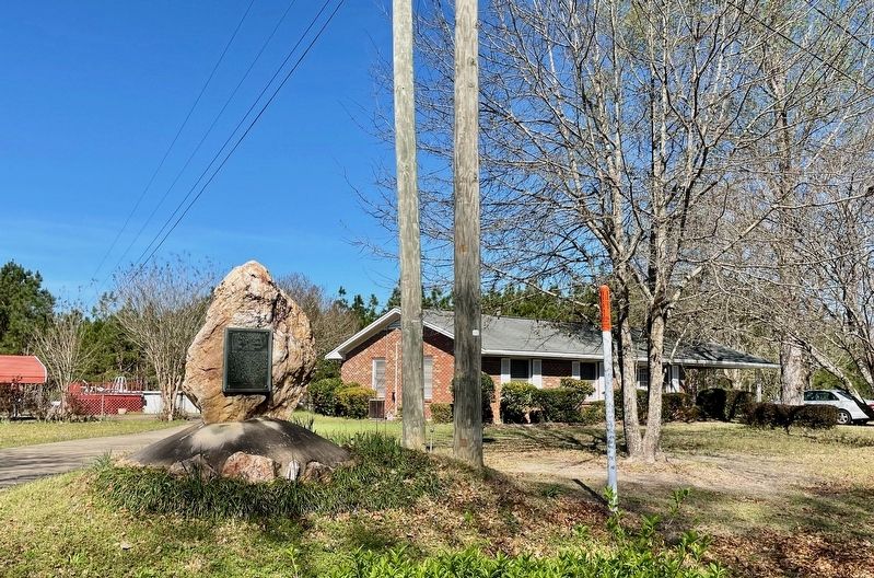
On Weoka Road (County Road 211) south of Grier Road, on the right when traveling south.
Here lived Lachlan Mc Gillivray,
a Scotch trader among the Indians.
His wife, Sehoy, was the daughter of
the French Captain, Marchand and
Sehoy of the Creek Tribe of the Wind.
Here was born their son, General
Alexander McGillivray, who went . . . — — Map (db m242547) HM
On North Bainbridge Street at Dexter Avenue on North Bainbridge Street.
Presented to the citizens of the State of Alabama honoring our brother George Washington our first Masonic President and in commemoration of 200 years of freedom under our constitutional form of government. — — Map (db m36644) HM
Near Montevallo Road (Alabama Route 119) 0.3 miles south of Alex Mill Road, on the right when traveling south.
(side 1)
The Lucille Ryals Thompson Colonial Chapel
Inspired by Bruton Parish Church of Williamsburg, Virginia, it was named to honor Lucille Ryals Thompson. The Chapel was built in thanksgiving for God’s blessings on America, and . . . — — Map (db m101505) HM
Near Montevallo Road (Alabama Route 119) 0.3 miles south of Alex Mill Road, on the right when traveling south.
(side 1)
The President's Oval Office
In this building is a full-scale replica of the White House Oval Office.
When John and Abigail Adams first moved into The White House in 1800, it contained three oval rooms, inspired by . . . — — Map (db m101531) HM
The American Revolution was a conflict between England and thirteen of her colonies in North America. Following years of taxation, suppression, and subjugation by the British, fighting began at Lexington and Concord, Massachusetts in 1775. A scant . . . — — Map (db m91470) HM
Our Constitution names the President of the United States the Commander in Chief of all the Armed Forces. Presidents who have served in our military are displayed on the following plaques. Each has served either on Active Duty, in the National . . . — — Map (db m92382) HM WM
On Memory Lane just east of Memorial Drive, on the right when traveling east.
Washington wears the uniform of the army
he had led through six bitter years of
war. In the midst of battle his fearless example
inspired his men; when hunger stalked his weary
troops, he shared their lot; when his own officers
betrayed him . . . — — Map (db m212621) HM WM
Near Ocean Avenue near Alta Avenue, on the right when traveling south.
In commemoration of the two-hundredth birthday of George Washington, first President of the United States, whose wisdom, foresight, and patriotism are an inspiration to all true Americans. — — Map (db m119721) HM
On Main Street, 0.1 miles north of South Street, on the right when traveling north.
French General Jean Baptiste Donatien de Vimeur, comte de Rochambeau, and thousands of French ground and naval forces arrived in Newport in July of 1780 to assist the Americans in the War for Independence. After wintering in Newport, Rochambeau’s . . . — — Map (db m243483) HM
On East Putnam Avenue (U.S. 1) at Maple Avenue, on the left when traveling north on East Putnam Avenue.
George Washington
Paused here on the Post Road near this church, on October 16, 1789 and afterward wrote in his diary, "the superb landscape which is to be seen from the meeting house is a rich regalia".
In Commemoration
Of this . . . — — Map (db m38428) HM
On Church Hill Road (U.S. 6) at Queen Street, on the right when traveling east on Church Hill Road.
1732 ---- 1932
In Commemoration Of
The Two Hundredth Birthday Of
George Washington
----
Rochambeau
Established a Camp Here
June 28 To July 1, 1781
----
Soldiers Commanded By
Lafayette
Camped At This Spot
Placed by Mary . . . — — Map (db m26914) HM
On Church Hill Road (U.S. 6) at Queen Street, on the right when traveling west on Church Hill Road.
French General Jean Baptiste Donatien de Vimeur, comte de Rochambeau, and thousands of French ground and naval forces arrived in Newport in July of 1780 to assist the Americans in the War for Independence. After wintering in Newport, Rochambeau’s . . . — — Map (db m26915) HM
Near Putnam Park Road (Connecticut Route 58) at Connecticut Route 107, on the right when traveling south.
The stone dam which makes this pond was installed at the time of the park’s creation. But the stream was in existence during the 1778-79 army encampment. It is one of two main streams, one at either end of the camp, which provided water for the . . . — — Map (db m26910) HM
On Ridgebury Road at George Washington Highway, on the right when traveling south on Ridgebury Road.
Ridgebury, "The New Patent," was one of the last land purchases made by the Proprietors. Tradition says that the First Congregational Church in Ridgebury had its beginnings in the "New Patent Meeting House" as early as 1738. In 1768 the . . . — — Map (db m32052) HM
On Ridgebury Road at George Washington Hwy., on the right when traveling south on Ridgebury Road.
Gathered Built 1760 1851 This property is listed in the National Register of Historic Places by the United States Department of the Interior < Second Plaque: > Connecticut Washington – Rochambeau Revolutionary . . . — — Map (db m23423) HM
On Ridgebury Road at Old Stagecoach Road, on the left when traveling south on Ridgebury Road.
French General Jean-Baptiste Donatien de Vimeur, Comte de Rochambeau, and thousands of French ground and naval forces arrived in Newport in July of 1780 to assist the Americans in the War for Independence. After wintering in Newport, Rochambeau’s . . . — — Map (db m23416) HM
On Atlantic Street at Main Street, on the right when traveling north on Atlantic Street.
Freedom Shrine
Created by the National Exchange Club
to strengthen citizen appreciation
of our American heritage
Presented by the Exchange Club of Stamford
Dedicated June 14, 1979
[ Reproductions of historic American documents are . . . — — Map (db m38610) HM
On Farmington Avenue (Connecticut Route 4) at Main Street (Connecticut Route 10), on the left when traveling east on Farmington Avenue.
Lest We Forget
In honor and grateful remembrance of our French Allies in the Revolution, whose army, under the command of General Count de Rochambeau, marched past this spot enroute from Newport and Providence, R.I., to join General Washington on . . . — — Map (db m190186) HM
Near Main Street near Central Row, on the right when traveling north.
Where You Are Standing
On September 20, 1780
Waits General George Washington,
Commander-in-Chief of the American Armies
During the American Colonies' Revolution
Against Great Britain.
He has come with Governor Trumbull and . . . — — Map (db m52783) HM
On Main Street at Gold Street, on the right when traveling north on Main Street.
George Washington
was entertained by
Colonel Jeremiah Wadsworth in his home on this site on June 30, 1775 when on his way to Cambridge to assume command of the Army.
On September 21, 22, 23, 1780 with Lafayette, General Knox and Governor . . . — — Map (db m151930) HM
Near Main Street near Central Row, on the right when traveling north.
Jonathan Trumbull
Where You Are Standing
From 1768 to 1784
Jonathan Trumbull guides the people of Connecticut
to independence as the colony's Royal Governor.
Governor Trumbull is the only colonial governor
to stand with the patriots . . . — — Map (db m52782) HM
Near Main Street at Central Row, on the right when traveling north.
This tablet commemorates the historic first meeting of General George Washington and General Comte de Rochambeau, commander-in-chief of the French army in America, which took place September 20, 1780.
On that occasion and in a subsequent meeting . . . — — Map (db m52914) HM
On Tower Square just west of Prospect Street, on the right when traveling west.
Jeremiah Wadsworth was Commissary-General in the Continental Army. His house which stood at the present site of the Wadsworth Atheneum was the meeting place for many leaders of the American Revolution, among them Washington, Lafayette, and . . . — — Map (db m151929) HM
On American Row at Main Street, on the right when traveling west on American Row.
Washington – Rochambeau Revolutionary Route
Hartford
French General Jean Baptiste Donatien de Vimeur, comte de Rochambeau, and thousands of French ground and naval forces arrived in Newport in July of 1780 to assist the Americans . . . — — Map (db m43739) HM
On Eddy Glover Boulevard at Commonwealth Avenue, on the right when traveling north on Eddy Glover Boulevard.
In Commemoration Of The
Bi-Centennial Anniversary Of The Birth Of
George Washington
These Trees Are Dedicated
Thanksgiving Day, November 24, 1932
Participating Organizations
American Legion, Eddy Glover Post No. 6 • American Legion . . . — — Map (db m221828) HM
On Main Street (Connecticut Route 10) at Grove Street, on the left when traveling north on Main Street.
Southington
French General Jean Baptiste Donatien de Vimeur, comte de Rochambeau, and thousands of French ground and naval forces arrived in Newport in July of 1780 to assist the Americans in the War for Independence. After wintering in . . . — — Map (db m165804) HM
On Hopmeadow Street (Connecticut Route 10) at Pent Road, on the left when traveling north on Hopmeadow Street.
This Elm Tree
Dedicated in Honor of the
Bicentennial of the Birth of
George Washington
Abigail Phelps Chapter D.A.R.
February 22, 1932 — — Map (db m87951) HM
On Marion Avenue at Burritt Street, on the right when traveling north on Marion Avenue.
Rochambeau
Lieut. General
Commanding
The Auxiliary French Armies
Under
Washington
July 10, 1780 Jan 11, 1783
Rochambeau's letter to Congress
"We are your brothers. We shall
conduct ourselves as such with you.
We shall fight . . . — — Map (db m33706) HM
On Main Street near Marsh Street, on the right when traveling north.
Washington – Rochambeau Revolutionary Route
Wethersfield
French General Jean Baptiste Donatien de Vimeur, comte de Rochambeau, and thousands of French ground and naval forces arrived in Newport in July of 1780 to assist the . . . — — Map (db m46299) HM
On Aspetuck Avenue at Elm Street, on the right when traveling north on Aspetuck Avenue.
This beautiful valley known to the Potatuck Indians as Weantinock, was purchased from them in 1703 by a company of individuals chiefly from Milford, Connecticut, hence the name New Milford. Its earliest white inhabitant, Zachariah . . . — — Map (db m22750) HM
On Bryan Hall Plaza at Calhoun Street (Connecticut Route 109), on the right when traveling west on Bryan Hall Plaza.
Side A
This township includes the villages of Woodville, New Preston, Marbledale, Washington, and Washington Depot. The eastern section, first settled by Joseph Hurlbut in 1734, was known as the Parish of Judea and belonged to Woodbury. The . . . — — Map (db m17437) HM
On Main Street South (U.S. 6) at Sherman Hill Road (Connecticut Route 64), on the right when traveling north on Main Street South.
In Memory Of
George Washington
1732 – 1799
These Trees Were Planted By The
Daughters Of The Cincinnati
To Commemorate The Bi-Centennial
1932 — — Map (db m29501) HM
On Main Street (Connecticut Route 17) at Fowler Road, on the left when traveling north on Main Street.
Durham
Coginchaug or “Long Swamp” was purchased from the Indians in 1673. A town plot was laid out in 1699, named Durham five years later, under a patent from King Charles II, and was confirmed by the General Assembly in 1708. It was . . . — — Map (db m94697) HM
On Foxon Road (Connecticut Route 80) at Forest Road (Connecticut Route 22), on the left when traveling west on Foxon Road.
This region was opened for settlement in the 1690's as the Third Division of the Town of Branford, originally called by the Indian name Totoket. The North or Second Ecclesiastical Society (1725) and the Third Society (1745), later named . . . — — Map (db m35313) HM
On Derby Avenue at Broad Street (Connecticut Route 313), on the right on Derby Avenue.
High hills and deep valley – broad river and rocky falls.
In 1650 “Nawcatock”, an Indian village. Today the river bears the name.
In 1678, “Amaugsuck”, the fishing place where the waters pour down.
From 1738, . . . — — Map (db m19991) HM
On North Main Street at Dutton Street, on the left when traveling north on North Main Street.
Nehemiah Royce House – 1672
Oldest Wallingford home built two years after the town was settled, overlooking "Dog's Misery." When General Washington came to Wallingford in 1775 he said farewell to the villagers in front of this house. . . . — — Map (db m27689) HM
Near East Main Street, on the left when traveling west.
This memorial was erected by Patriotic Citizens and Statesmen to commemorate two French Soldiers of Rochambeau's Army who volunteered to fight for American Independence under Washington, enroute from Newport to Yorktown, died and were buried here, . . . — — Map (db m36024) HM
On West Main Street at Church Street, on the right when traveling east on West Main Street.
Washington – Rochambeau Revolutionary Route
Waterbury, Middlebury, Southbury
French General Jean Baptiste Donatien de Vimeur, comte de Rochambeau, and thousands of French ground and naval forces arrived in Newport in July of 1780 to . . . — — Map (db m190232) HM
On Main Street at Norwich Avenue, on the right when traveling north on Main Street.
Colchester
The eighth town in the Colony incorporated before 17OO, Colchester received its charter in 1698. Among the early settlers from Wethersfield was Nathaniel Foote, whose ancestors came from Colchester, England. He obtained a deed for the . . . — — Map (db m98960) HM
On West Town Street at Exeter Road (Connecticut Route 207), on the left when traveling north on West Town Street.
Lebanon, Connecticut
Governor Jonathan Trumbull’s War Office
Headquarters of the
Connecticut Council of Safety During
The War of the American Revolution
Erected by the
Connecticut George Washington Bi-Centennial Commission
October 8, . . . — — Map (db m189612) HM
On West Town Street at Exeter Road (Connecticut Route 207), on the left when traveling north on West Town Street.
Winter Encampment in Lebanon
French General Jean Baptiste Donatien de Vimeur, comte de Rochambeau, and thousands of French ground and naval forces arrived in Newport in July of 1780 to assist the Americans in the War for Independence. After . . . — — Map (db m242004) WM
On Water Street at State Street, on the left when traveling north on Water Street.
A Yale graduate, Hale began teaching here in the Union School House in 1774. He taught all ages and levels of boys at the same time. A progressive teacher for his day, Hale openly rewarded success in the classroom. He also believed in teaching . . . — — Map (db m48320) HM
On Washington Street at Veterans of Foreign Wars Highway (Route 2), on the right when traveling south on Washington Street.
Leffingwell Inn
In 1675, Steven Backus built a simple two-room, side-chimney house. Over two centuries, it would be modified many times. Thomas Leffingwell, a founder of Norwich and friend of the Great Sachem, Uncas, bought the house in 1700 and . . . — — Map (db m101942) HM
On Bolton Center Rd at Hebron Rd, on the right when traveling east on Bolton Center Rd.
Formally known as Hanover or Hartford Mountains, this town was incorporated in 1720, having been settled by a group of “good Christian men” desiring more open farmland.
In 1781 the French army of General Rochambeau, on their way to aid the army . . . — — Map (db m140602) HM
On Bolton Center Rd at Hebron Rd, on the right when traveling east on Bolton Center Rd.
Bolton
French General Jean Baptiste Donatien de Vimeur, comte de Rochambeau, and thousands of French ground and naval forces Arrived in Newport in July of 1780 to assist the Americans in the War for Independence. After wintering in Newport, . . . — — Map (db m190090) HM WM
On Huntington Road (Connecticut Route 14) at Pinch Street, on the left when traveling east on Huntington Road.
Eastern Connecticut
French General Jean Baptiste Donatien de Vimeur, comte de Rochambeau, and thousands of French ground and naval forces arrived in Newport in July of 1780 to assist the Americans in the War for Independence. After wintering in . . . — — Map (db m190106) HM
A native of Virginia's Eastern Shore, Mifflin came to Delaware as a young man. Born into a slaveholding Quaker family, he manumitted his own slaves in 1774-75 and later became one of America's foremost abolitionists of the 18th century. As an elder . . . — — Map (db m39456) HM
Colonel John Haslet-A native of Ulster, Ireland, John Haslet was born circa 1728 and emigrated to America about 1757. After playing an active role in the Pennsylvania militia during the French and Indian War, Haslet eventually settled in the Milford . . . — — Map (db m142542) HM
For many years this home was the property of Colonel Allen McLane, statesman and hero of the American Revolution.
Born in Philadelphia August 8, 1746, McLane had moved to Delaware by 1769. His military career began when he was commissioned . . . — — Map (db m39028) HM
The federal government recognized the need for a militia. It is mentioned in the Constitution and the Bill of Rights. The 2nd Amendment states “A well-regulated Militia, being necessary to the security of a free State, the right of the people to . . . — — Map (db m140181) WM
The great debt we owe the French people was repaid 136 years later during the First World War when the American Expeditionary Force arrived in France. On July 4, 1917, American troops marched through Paris, ending at the grave of Lafayette. At . . . — — Map (db m168721) HM
On Sunset Lake Road (Delaware Route 72). Reported damaged.
The federal government recognized the need for a militia. It is mentioned in the Constitution and the Bill of Rights. The 2nd Amendment states “A well-regulated Militia, being necessary to the security of a free State, the right of the people to . . . — — Map (db m140138) HM
On Stanton-Ogletown Road, 0.3 miles north of Ogletown-Stanton Road, on the right when traveling north.
George Washington's "General Staff Headquarters" on September 6, 1777. Here Generals Washington, Lafayette, Wayne, Maxwell, Sullivan, and Greene planned defense of Wilmington. House built circa 1750 by Samuel Hale. Owner 1776 - Daniel Byrnes - a . . . — — Map (db m13555) HM
On Sunset Lake Road (Delaware Route 72) south of Old Baltimore Pike, on the right when traveling south.
The great debt we owe the French people was repaid 136 years later during the First World War when the American Expeditionary Force arrived in France. On July 4, 1917, American troops marched through Paris, ending at the grave of Lafayette. At . . . — — Map (db m156795) HM
A Victorious Allied Army Passed Here
1781 was a momentous year for the United States. A French Army, led by General Rochambeau, had arrived in Rhode Island in July 1780. By June 1781, it was ready to join the U.S. Continental Army against . . . — — Map (db m189558) HM
On South Old Baltimore Pike at (south) Old Cooches Bridge Road, on the right when traveling west on South Old Baltimore Pike.
American light infantry and cavalry under General William Maxwell encountered advance guard of British and Hessian troops under Generals Howe, Cornwallis and Knyphausen in this vicinity September 3, 1777. American troops were expert marksmen drafted . . . — — Map (db m147686) HM
On South Old Baltimore Pike, on the right when traveling west.
Generals Washington, Greene and Lafayette came to Iron Hill, August 26, 1777 in hope of viewing British army then landing along Elk River. Only a few tents could be seen. A heavy storm coming up, they spent the night in a nearby farm house. — — Map (db m9778) HM
On September 4-7, 1781, residents of Brandywine Village watched as thousands of American and French troops marched through their community along the King’s Highway on their way to Yorktown, Virginia. The combined forces, under the commands of . . . — — Map (db m140593) HM WM
Built about 1760. Anthony Wayne's Headquarters 1777. Generals Washington, Lafayette, Wayne, and other officers met here to hold council and hear reports prior to the Battle of Brandywine. Later occupied by British. Joseph Tatnall owned and operated . . . — — Map (db m185987) HM
On Concord Pike, 0.2 miles north of Delaware Route 261, on the right when traveling north.
1747-1812. Member of Continental Congress and of Annapolis Convention. A framer of United States Constitution, which Delaware was first to ratify. Appointed First District Judge of Delaware by President Washington. Purchased this property 1793 as . . . — — Map (db m14706) HM
On North Market Street south of East 9th Street, on the left when traveling south.
During the American Revolution Lauzun's Legion spent the winter and spring of 1782-1783 in Wilmington to help guard Philadelphia and Baltimore from British attack. The troops were housed in the Wilmington Academy, located where the Grand Opera . . . — — Map (db m166673) HM
Near New Jersey Avenue Northwest just south of C Street Northwest, on the right when traveling north.
Here were the lots acquired on October 3, 1798 by General George Washington and on which he built two brick dwellings from designs by Dr. William Thornton. A dwelling remodeled from the two dwellings was owned and occupied by Admiral Charles Wilkes . . . — — Map (db m181817) HM
On Pennsylvania Avenue Northwest at Jackson Place Northwest, on the right when traveling west on Pennsylvania Avenue Northwest.
[front, south face:]
Rochambeau
[back, north face:]
"We have been contemporaries and fellow labourers in the cause of liberty, and we have lived together as brothers should do, in harmonious friendship," . . . — — Map (db m32973) HM
On Massachusetts Avenue Northwest at 22nd Street Northwest on Massachusetts Avenue Northwest.
“He had the mind of a scholar, the figure of a sportsman, the bearing of an aristocrat, the position of a king. But he had the heart of a democrat. ...”
Dorothy Thompson, NBC broadcast, September 24, 1957. . . . — — Map (db m30417) HM
On H Street Northwest east of 21st Street Northwest, on the right when traveling east.
An authorized cast bronze by the Gorham Foundry from the original by Jean Antoine Houdon (1741-1828) which stands in the State Capitol at Richmond, Virginia. It was purchased by The George Washington University in 1932 on the occasion of the George . . . — — Map (db m47315) HM
On 21st Street Northwest at I Street Northwest, on the right when traveling south on 21st Street Northwest.
"George Washington" is a bronze sculpture by Avard T. Fairbanks, Ph.D. (1897-1987). This bronze was donated by Sylvia West Fairbanks and David N.F. Fairbanks, M.D. and Family and was dedicated on this spot on February 16, 1993.
"George . . . — — Map (db m111546) HM
On G Street Northwest at 20th Street Northwest on G Street Northwest.
A photo-collage celebrating The George Washington University's Permanent Collection incorporates a selection of outdoor sculpture and paintings. GW has enhanced the pedestrian environment in and around the Foggy Bottom campus.
Artists: . . . — — Map (db m111948)
On 21st Street Northwest at H Street Northwest, on the right when traveling south on 21st Street Northwest.
Legend has it that the Potomac was once home to these wondrous beasts.
George and Martha Washington are even said to have watched them cavort in
the river shallows from the porch of their beloved Mount Vernon on summer evenings. . . . — — Map (db m46980) HM
On I Street Northwest west of 21st Street Northwest, on the right when traveling east.
Dedicated in honor of the Marquis de Lafayette (1757-1834), a hero of the American Revolution, defender of liberty, statesman, and good friend of George Washington.
In 1777 the 20-year old Marie-Joseph-Paul-Yves-Roch-Gilbert du Motier, Marquis . . . — — Map (db m95180) HM
On M Street Northwest east of 34th Street Northwest, on the right when traveling east.
• Site of a dinner hosted by General Uriah Forrest for his old friend and former commander, President George Washington, on March 29, 1791. Landowners of Carrollsburg and George town attended. An agreement was reached for the sale of half of . . . — — Map (db m82654) HM
On Wisconsin Avenue Northwest at N Street Northwest, on the right when traveling south on Wisconsin Avenue Northwest.
Among the first businesses in historic Georgetown were its inns and taverns. They not only offered food, drink and lodging, but were focal points of community life where political debate and civic meetings took place and business deals were made. . . . — — Map (db m121195) HM
On Q Street Northwest just west of 27th Street Northwest, on the right when traveling west.
Erected by
The National Society of the Colonial Dames of America
In Grateful Commemoration of the Signing of the Constitution
by the following delegates in Philadelphia September 17, 1787
Attest: William Jackson, Secretary . . . — — Map (db m189261) HM
The Residence Act of 1790 established a 10-mile square along the Potomac River as the permanent seat of the United States government. President George Washington was authorized to select the site and appoint a commission to oversee the planning . . . — — Map (db m211191) HM
On Florida Avenue Northwest at Massachusetts Ave Northwest, on the right when traveling south on Florida Avenue Northwest.
Here is an elegant George Washington trotting on his handsome horse. Our first president never lived in the city that bears his name, but in the late 1700s you might have glimpsed Washington riding along the Post Road, a highway that connected . . . — — Map (db m112624) HM
On 1st Street Northwest at New Jersey Avenue Northwest, on the right when traveling north on 1st Street Northwest.
"No nation perhaps had ever before the opportunity offer'd them of deliberately deciding on the spot where their Capital city should be fixed..." - Peter C. L'Enfant to George Washington, September 11, 1789
A new nation . . . — — Map (db m60127) HM
On 15th Street Northwest at Madison Drive Northwest, on the left when traveling north on 15th Street Northwest.
The Washington Monument honors George Washington, hero of the American Revolution and first president of the United States. When this stunning stone obelisk was completed in 1884, it was the tallest building in the world. Today the monument . . . — — Map (db m194663) HM
Near 17th Street Northwest south of Constitution Avenue Northwest (U.S. 50), on the right when traveling north.
The Washington Monument honors George Washington, hero of the American Revolution and first president of the United States. When this stunning stone obelisk was completed in 1884, it was the tallest building in the world. Today the monument . . . — — Map (db m211345) HM
Near 15th Street Northwest south of Madison Drive Northwest, on the right when traveling south.
George Washington shaped many aspects of the nation's capital. He championed placing the capital along the Potomac River then personally selected the site. He chose architect Pierre L'Enfant to design the city. L'Enfant envisioned a capital with . . . — — Map (db m194169) HM
Near 15th Street Southwest north of Jefferson Drive Southwest, on the right when traveling south.
The Washington Monument honors George Washington, hero of the American Revolution and the first president of the United States. When this stunning stone obelisk was completed in 1884, it was the tallest building in the world. Today the monument . . . — — Map (db m109322) HM
On South Carolina Avenue Southeast just east of 6th Street Southeast, on the right when traveling east.
Since 1936 Friendship House, across the street, has operated an array of social service programs from this grand Federal style house, also known as "The Maples." Friendship House is the city's oldest such agency. It was founded in 1904 by . . . — — Map (db m166999) HM
On 8th Street Southeast at L Street Southeast, on the right when traveling south on 8th Street Southeast.
Most of the land that is now Capitol Hill—including portions of the Navy Yard – once belonged to William Prout, who lived in a large house on this block. In 1799 and 1801 he sold and traded land to the U.S. government for both the . . . — — Map (db m130742) HM
Near 17th Street Southwest north of Independence Avenue Southwest, on the right when traveling north. Reported missing.
The Washington Monument honors George Washington, hero of the American Revolution and first president of the United States. When this stunning stone obelisk was completed in 1884, it was the tallest building in the world. Today the monument . . . — — Map (db m194688) HM
On Raoul Wallenberg Place Southwest at Jefferson Drive Southwest, on the right when traveling south on Raoul Wallenberg Place Southwest.
The Washington Monument honors George Washington, hero of the American Revolution and first president of the United States. When this stunning stone obelisk was completed in 1884, it was the tallest building in the world. Today the monument . . . — — Map (db m211343) HM
On 17th Street Southwest just north of Independence Avenue Southwest, on the right when traveling north.
George Washington shaped many aspects of the nation's capital. He championed placing the capital along the Potomac River then personally selected the site. He chose architect Pierre L'Enfant to design the city. L'Enfant envisioned a capital with . . . — — Map (db m211376) HM
On 17th Street Southwest just north of Independence Avenue Southwest, on the right when traveling north.
The Washington Monument honors George Washington, hero of the American Revolution and the first president of the United States. When this stunning stone obelisk was completed in 1884, it was the tallest building in the world. Today the monument . . . — — Map (db m211377) HM
In the late 1700s, the British government under King George III imposed harsh taxes and laws on the residents of its American colonies. The Continental Congress was formed as a response to this in 1774 by men who would become the founders of United . . . — — Map (db m173862) HM
On Myrtle Avenue just south of West 6th Street, on the left when traveling north.
1 • Martin Luther King, Jr. Sycamore Planted on March 4, 2000 by family in memory of Ethel Mae Monroe. The Martin Luther King, Jr. Sycamore stands in front of Brown Chapel AME, a church in Selma, Alabama, where the dedicated young . . . — — Map (db m214872) HM
Near West 7th Street just west of Myrtle Avenue, on the right when traveling west.
1 • Mount Vernon Red Maple Planted in honor of the Founders of the City of Sanford, Florida on February 10, 1992. This red maple has been grown from seeds collected at Mount Vernon, President George Washington's beloved home on the . . . — — Map (db m214875) HM
On Waleska Highway (Georgia Route 140) 0.1 miles west of Deer Lodge Road, on the left when traveling east.
Pine Log Town, located on Pine Log Creek in the flat fields slightly over a half mile east of Oak Hill Church north of GA 140, (in Pine Log, Georgia), extended almost a mile along the creek. The lots were 293, 294, 295,296, 317, 318, 284,and 283, in . . . — — Map (db m13190) HM
On South Liberty Street (U.S. 25) 0 miles south of West 6th Street (Georgia Route 80), on the right when traveling south.
The game is yet in our own hands; to play it well is all we have to do – nothing but harmony, honesty, industry and frugality are necessary to make us a great and happy people.
George Washington — — Map (db m59851) HM
On North Liberty Street (U.S. 25) near Sixth / Peace Street (Georgia Route 56).
Traveling from Savannah to Augusta on his Southern tour of 1791, President George Washington stopped in Waynesboro on May 17. Departing from Savannah two days earlier, Washington lodged at "one Spencers " in Effingham County, fifteen miles north of . . . — — Map (db m7800) HM
On E. 6th Street at N. Liberty Street, on the right when traveling west on E. 6th Street.
On July 31, 1783, an Act was passed by the General Assembly meeting in Augusta to lay out a town, Waynesborough, on reserved or private land. Commissioners named (Thomas Lewis, Sr., Thomas Lewis, Jr., John Duhart, Edward Telfair, John Jones) were . . . — — Map (db m7868) HM
On Okefenokee Parkway (Georgia Route 40) 1 mile west of Ga. Hwy 110, on the left when traveling south.
On June 29, 1796, this Treaty was signed ¼ mile south of here near Indian Agent James Seagrove’s home, a trading post and garrison of Federal troops on the St. Marys River. The meeting included representatives of the United States and the State of . . . — — Map (db m60207) HM
1028 entries matched your criteria. The first 100 are listed above. Next 100 ⊳