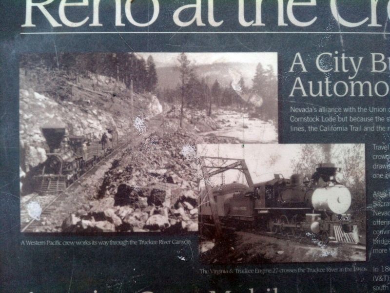
A City Built on Trains and Automobiles
Nevada's alliance with the Union during the Civil War was important not only for the mineral resources of the Comstock Lode but because the state held portion of the transcontinental transportation and . . . — — Map (db m113036) HM
The Henness Pass Road was a major immigrant trail from the Truckee Meadows to the California gold fields. In the 1850's it was improved and became a toll road. In 1860 Felix O'Neil built a bridge over the Truckee River, east of this place and near . . . — — Map (db m94297) HM
These are the first Lincoln Highway bridge rails ever built on the nation's first transcontinental highway. The Abraham Lincoln Highway ran from Times Square, New York, to Lincoln Park in San Francisco, during 1913-1927.
Towns all across the . . . — — Map (db m67269) HM
James H. Simpson put the future site of Ely on the map during his 1859 exploration through the Great Basin. In the 1860's, silver and gold deposits were discovered nearby in what became the Robinson Mining District. Ely developed as a regional . . . — — Map (db m69490) HM
The Visionary: Carl Fisher was a dreamer with an entrepreneurial spirit. After amassing a large fortune and building a reputation in the auto-parts industry, Fisher began to dream of building a paved hard-surface, coast-to-coast highway. He . . . — — Map (db m67131) HM
This historical bridge was built on this site in 1927 by the Allen County Engineers office. When opened, it carried the Delphos-Upper Sandusky Road, U.S. Route 30, commonly referred to as the Lincoln Highway, over the Ottawa River and served as an . . . — — Map (db m78696) HM
The Lincoln Highway, America's first trans-continental route, was officially opened in June, 1915, amid widespread local celebrations.
The highway (US Route 30) originally entered the city's East End, but later alterations caused it to cross into . . . — — Map (db m44172) HM
This monument, erected by lodge members and friends, is affectionately dedicated
to the memory of John Edward Hopley, 1850 - 1927, pioneer in Lincoln Highway development. First state consul for Ohio of the Lincoln Highway Association. In 1887 he . . . — — Map (db m135375) HM
Replica marker
commemorating the
Lincoln Highway
which passed through
Galion from 1913 to
1921. Known here at
that time as Lincoln
Way West and East.
The Galion Area
Betterment Commission — — Map (db m181450) HM
Founded In 1834. Birthplace and home of Civil War Congressional Medal of Honor Winner William Haliday Williams, Company C, 82nd Volunteer Infantry.
Founded in 1834 by John W. Williams. A popular stop for travelers and truckers on the . . . — — Map (db m159684) HM WM
From 1947 to 1956 Mark and Betty Lutz owned a diner called Mark's Dairy Bar on this site on historic Lincoln Highway. Mark's Dairy Bar was operated by Betty. She was quite the multi-tasker; preparing food, serving, washing dishes, socializing with . . . — — Map (db m164101) HM
Here Lies Robert Nesbitt. This is the grave site of Robert Nesbitt, an immigrant from Convoy, Ireland who named Convoy, Ohio after his home town. In 2010, the Convoy Community Foundation, Convoy Lions Club, Convoy Business Association, and . . . — — Map (db m178428) HM
Conceived by leaders of the automobile industry to encourage the building of "good roads," the Lincoln Highway was established in 1913 as the first transcontinental automobile route in the United States. It traversed twelve states and 3,389 . . . — — Map (db m93866) HM
The Lincoln Highway was the first coast-to-coast highway built in 1913. A group of visionary businessmen from the automotive industry, led by Henry B. Joy and Carl Fisher, formed the Lincoln Highway Association. The Association successfully . . . — — Map (db m167234) HM
Charles W. Johnson was the proprietor of the general store in McKnightstown for 62 years. This store is now the site of the post office. Johnson began working at the General Store under Calvin T. Lower and then later purchased the store. Oil, . . . — — Map (db m150317) HM
Pennsylvania is well known for its beautiful farming country, fruit belts and unique barns. Many are located along the historic Lincoln Highway route. The Round Barn is one of the more unique examples.
Considered an "endangered species," . . . — — Map (db m167237) HM
The historic Cashtown Inn has been offering lodging and dining to weary travelers since the turn of the 19th Century. Roads were important to town development, just as the automobile was important to their prosperity. As roads brought travelers . . . — — Map (db m167235) HM
General Robert E. Lee and his staff planned one of America's greatest battles at this site. Almost a century later the site began offering overnight accommodations to travelers coming to pay homage to their heroes. Gutted by fire in 1896, the . . . — — Map (db m94496) HM
By the end of the 1920s the federal highway system changed names of early routes to a system of standardized numbering. In Pennsylvania and across other states, the Lincoln Highway was renamed U.S. Route 30. This was also the time that the Lincoln . . . — — Map (db m130305) HM
Traveling the Lincoln Highway gave people a sense of freedom and spontaneity. However, there came a new responsibility — taking care of the vehicle. Livery stables and blacksmith shops were replaced by gasoline and service stations. As a result, . . . — — Map (db m130306) HM
During the 19th century, railroads had become primary arteries transporting the public over long distances. The honk of automobile horns, however, sounded the death knell for many passenger railroads. With advances in road building, technology and . . . — — Map (db m105532) HM
The increased number of automobiles during the Lincoln Highway era (1912-1940) led to the development of programmatic architecture. Proprietors took daring approaches to appeal to the new motoring public.
All across the country, oversized . . . — — Map (db m13998) HM
Nearly three centuries of transportation history can be found in Pennsylvania: native American paths to wagon trails, early canals and railroads, the Forbes and Burd Roads, and a string of ten other turnpikes. However, none were more important in . . . — — Map (db m166856) HM
Nearby water gaps have made this an important transporation corridor for thousands of years. Native American trails, 18th century military roads, the Pennsylvania Road, the Chambersburg and Bedford Turnpike, the Lincoln Highway, US 30, and the . . . — — Map (db m52667) HM
During World War II, the Gateway was considered to be a major stop-off for many servicemen and women who were on their way to Maryland, Virginia, the Carolinas and westward. This prime location near the turnpike interchange in Breezewood and along . . . — — Map (db m337) HM
Shortly after the Pennsylvania Turnpike opened in 1941, Snyder's Gateway Inn was one of the first businesses to appear. Merle and Marian Snyder opened the restaurant shortly before World War II began and eventually supplied fuel to the military . . . — — Map (db m167357) HM
Located just a stone's throw from the Forbes Road (later the Lincoln Highway), the Everett Foundry and Machine Shop was the place to go for machine parts, welded pieces, molds or bells. The business was started in 1854 by Josiah and Jeremiah . . . — — Map (db m134810) HM
In the early 1900s two local boys made a name for themselves in the automobile world. Chester (Chet) and Clayton Karns of Everett were pioneers in the automobile industry. The American Automobile Association (AAA) recognized the brothers as the . . . — — Map (db m134815) HM
The village of Bloody Run, later named Everett, was planned by Michael Barndollar in 1785. Barndollar also built the Union Hotel at this site in 1808. It was known as one of the finest hotels in existence at that time. During the flood of 1936 . . . — — Map (db m134813) HM
At the end of the 1800s, most people lived less than 20 miles from a railroad station. By the early 1900s new paving techniques created opportunities for improved roads, like the Lincoln Highway. With automobile travel there were new levels of . . . — — Map (db m134812) HM
Travel reached its peak with the birth of automobiles. For the sake of convenience and price, motor camping was soon the latest trend. However, it wasn't long that travelers wanted heat, water, food and gas. As a result, entrepreneurs had the . . . — — Map (db m166739) HM
Even when blessed with good roads and good weather, crossing the Alleghenies on the Lincoln Highway was a challenge for the early motorist. Steep grades and winding roads resulted in overheated engines and severe cases of vertigo. Entrepreneurs . . . — — Map (db m61117) HM
By 1923, motor camping was the number one national pastime. Automobiles provided average Americans a new type of freedom and a way to escape their daily routine by touring the countryside on short weekend trips or cross-country treks. But it . . . — — Map (db m120992) HM
In the early days of the automobile, owning a car was considered a novelty. It was also considered a major expense. People had to buy cars outright in cash. As a result it was not surprising that owners wanted to protect their investment by parking . . . — — Map (db m122137) HM
The French and Indian War (1754-1760) marked the entrance of Pennsylvania into world history and into the road system. General John Forbes selected the best Indian paths that would serve his military objectives of reclaiming western Pennsylvania . . . — — Map (db m166787) HM
This was the nations first major toll road, built by a private company incorporated 1792 by the state legislature. Completed two years later and praised as the finest highway of its day, the stone-and-gravel turnpike stretched 62 miles. The 35th . . . — — Map (db m8262) HM
Arches were a common site across the Lincoln Highway route. A Gateway Arch, now removed, spanned Lincoln Way East. The wooden arch greeted travelers as they passed through downtown. It was at this very intersection (Lincoln Highway and U. S. . . . — — Map (db m35181) HM
Lincoln Highway travelers were not unlike today's travelers – wanting good roads, reasonably priced food and overnight accommodations, and quality entertainment. The Capitol Theatre, which celebrated its grand opening on the night of February 3, . . . — — Map (db m242173) HM
The boom of the automobile industry led to another explosion — the restaurant industry. Americans were experiencing two new forces — the urge to ride in the car, and the urge to eat out. The restaurant could serve the hungry motorist and . . . — — Map (db m152350) HM
Dodie's Restaurant holds an important place in the history of Franklin County dining establishments. In 1949, Kenny Hoover started a frozen custard stand in a remodeled Atlantic gas station near the Route 81 intersection. Once business prospered, he . . . — — Map (db m167239) HM
The stone walls of this old building have withstood the adversities of time and people to stand in mute testament of historical events that helped shape a nation. Built in 1837, partners John Paxton and Thaddeus Stevens erected a blacksmith . . . — — Map (db m201760) HM
(Left Side): The Good Roads Jubilee One of the largest celebrations for the opening of a paved section of the Lincoln Highway was held here, at the Caledonia Forest Reserve Park, on October 4, 1921. The new paved section of the Lincoln . . . — — Map (db m11702) HM
Family-owned businesses on Main Street have evolved to meet changes in demand for products. Stoner's Novelty Store is a good example. Albert Stoner built this structure in 1899 as a tinsmith workshop and store. In the 1920s, his son Frank expanded . . . — — Map (db m19566) HM
Over the course of the last century, the facades and functions of Main Street businesses across America have evolved. In the 1920s and '30s, Linn Motor Sales, a car dealership and service station, occupied this site. Since that time, the building . . . — — Map (db m167240) HM
Located at the fork of Route 16 and “The Lincoln Way -the Road Without Toll,” Johnnie's Motel was built in the 1940s to serve the many motorists passing through McConnellsburg. The motel's neon sign advertises “rooms with private showers!” Business . . . — — Map (db m167241) HM
Carved out of a remote wilderness, McConnellsburg served the flood of travelers heading west in the late 18th century. Taverns, like the Fulton House, sprang up all along the packhorse trail from Philadelphia to Pittsburgh.
Whether by . . . — — Map (db m167242) HM
The country's first coast-to-coast highway was established in 1913 by the Lincoln Highway Association, largely by improving and linking existing roads between New York and San Francisco. The highway changed the way people traveled and the landscape . . . — — Map (db m5761) HM
Lancaster Walk aligns with the original Philadelphia and Lancaster Turnpike, the nation's first major toll road, opened in 1794. The Turnpike originated just east of this location, at Lancaster Walk's intersection with Market Street, and extended 62 . . . — — Map (db m223995) HM
Built in 1853 by John H. Hite, this building has served as the principle (sic) hotel for thousands of stagecoach, railroad, and later automobile travelers between Bedford and Greensburg. In the 1870s it was enlarged from two to three stories, and . . . — — Map (db m52756) HM
The 1924 Complete Official Road Guide of the Lincoln Highway reports that Stoystown (population, 400) had a speed limit of 15 mph, enforced! Located about a block east from this location is one of the original Lincoln Highway cement . . . — — Map (db m232914) HM
Lincoln Highway hotels possessed a mystique lacked by the more basic tourist cabins. Doormen carried the visitors' bags, and dinner was served by a waiter rather than from a tin can at a campsite. Seven hotels were located in the City of Greensburg . . . — — Map (db m155795) HM
Road versus Rail—The Lincoln Highway stretches from New York City to San Francisco. In Western Pennsylvania, the Highway converges with the Pennsylvania Railroad Main Line at one location: Greensburg.
The train station at Greensburg, . . . — — Map (db m166714) HM
The Lincoln Highway was the first coast-to-coast highway built in 1913. A group of visionary businessmen from the automotive industry, led by Henry B. Joy and Carl Fisher, formed the Lincoln Highway Association.
The Association successfully . . . — — Map (db m166861) HM
A residence and farm, a stagecoach stop, a tavern, an office building and a museum!
In 1812, Scotch-Irish immigrant Alexander Johnston (who lived to be almost 100 yrs.) began erecting this landmark structure. The stone for the building and . . . — — Map (db m167362) HM
This cement marker is one of 3,000 markers that were erected along the Lincoln Highway from New York City to San Francisco, approximately one per mile.
On September 1, 1928, cement posts with bronze medallions bearing President Lincoln's profile . . . — — Map (db m49264) HM
In 1895, people from Pittsburgh could find refuge from the hustle and bustle of the city in Ligonier. At this time, Mr. Wiliam J. Potts, Ligonier's first Mayor, built a Victorian residence on this site for his wife Jessamine. It was the first home . . . — — Map (db m49265) HM
Pleasure driving along the Lincoln Highway has long been a popular pastime. Motorists sought and continue to seek scenic beauty and amusements, such as Idlewild Park.
For most of its history, the Lincoln Highway was lined with attractions, . . . — — Map (db m167244) HM
The rise and fall of the railroad corresponded to the continuing increase of roads, like the Lincoln Highway. Railroads were needed for transportation because roads were virtually impassable. But once new paving techniques made road surfaces . . . — — Map (db m49218) HM
As the Lincoln Highway prospered, many towns saw the introduction of automobile dealerships onto Main Street. In 1920, A.J. McColly purchased this site, tore down two frame houses, along with a blacksmith shop, and erected this building for his . . . — — Map (db m167245) HM
This small pine tree that seems to be growing out of solid rock has fascinated travelers since the first train rolled past on the Union Pacific Railroad. It is said that the builders of the original railroad diverted the tracks slightly to pass by . . . — — Map (db m62159) HM
"That there should be a Lincoln Highway across this country is the most important thing"
In memory of Henry B. Joy
The first president of the Lincoln Highway Association
Who saw realized the dream of a continuous improved highway from the . . . — — Map (db m84887) HM
This monument commemorates the Lincoln Highway, America's first transcontinental automobile road, and Henry Bourne Joy, the first president of the Lincoln Highway Association (1913). Joy, also president of the Packard Motor Car Company, is sometimes . . . — — Map (db m47145) HM
Officially abandoned in 1886, the fort came under the jurisdiction of the Department of the Interior in 1887. In 1892 and 1893 most of the buildings were sold a public auction. In 1897 the land, opened to homesteading, was patented by the Union . . . — — Map (db m89913) HM
plus other lines of transportation and communication - train, telegraph and telephone - bisected America while linking its east and west coasts during one of our nation's most remarkable eras of development. Those lifelines also sustained the . . . — — Map (db m89924) HM
The Lincoln Highway was America's first transcontinental highway, conceived in 1912 specifically with the automobile in mind. Although parts of the Lincoln Highway were first used in 1908 for the famous New York to Paris automobile "Great Race", it . . . — — Map (db m95580) HM
This was the original location of the Henry B. Joy Lincoln Highway Monument placed in 1938 following Joy's death. Henry Bourne Joy was president of the Packard Motor Car Company and the first president of the Lincoln Highway Association. The Lincoln . . . — — Map (db m67960) HM
The Lincoln Highway was established in 1913 as the nation's first coast-to-coast automobile route. It consisted of existing roads that were marked with the distinctive Lincoln Highway logo. Perhaps the most famous means of identification was . . . — — Map (db m67739) HM
In 1928, the Boy Scouts erected 2,400 of these monuments to commemorate the first Coast to Coast Highway from New York to San Francisco.
We dedicate this monument to the memory of Mr. Albino Fillin of Fort Bridger who though to save it for . . . — — Map (db m90689) HM
174 entries matched your criteria. Entries 101 through 174 are listed above. ⊲ Previous 100