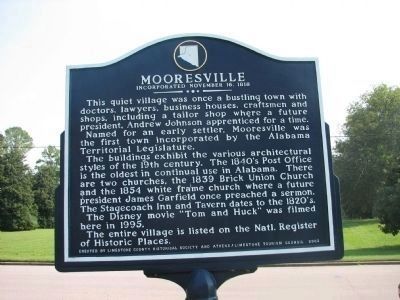
On Old Highway 20 at Mooresville Road on Old Highway 20.
Front The town of Cottonport flourished in the early years of Limestone County. It was settled in 1818 and chartered in 1824. It was located approx. 1½ miles S.E. near the point where Limestone Creek flowed into the Tennessee River and . . . — — Map (db m85455) HM
On Old Highway 20 at Mooresville Road on Old Highway 20.
Post office contains original call boxes
Old tavern, 1817 used as stagecoach stop
Red Brick Methodist church 1817
U.S. Gen. James A Garfield was stationed here 1862
White frame church is more than a century old
Andrew Johnson was . . . — — Map (db m28154) HM
[Written on the initial marker, provided for context]
Our Constitution names the President of the United States the Commander in Chief of all the Armed Forces. Presidents who have served in our military are displayed on the following . . . — — Map (db m92389) HM WM
The Fort Smith Council was held in this building in September 1865. To establish relations following the Civil War, delegates of twelve Indian nations met with President Andrew Johnson’s representatives. Bitterly divided, Indians had fought for both . . . — — Map (db m59025) HM
Near Cabrillo Highway (California Route 1), on the right when traveling south.
Spanish explorers and later New England hide and tallow traders found the Big Sur coastline a great hazard. Heavy fogs and extreme winds caused the wreck of many vessels on this coast. The Gold Rush of 1849 dramatically increased coastal shipping. A . . . — — Map (db m68643) HM
Near Washington Street near Yount Street, on the left when traveling north.
In 1870, the year in which the Groezinger Winery (now Vintage 1870) was built, these flags: the California Bear flag (note how much more primitive in design it is in contrast with the present day version) and the American flag (then with 37 stars) . . . — — Map (db m103540) HM
Near Stanton Road near Big Creek Road, on the left when traveling north.
Indian Days
Most of the Indian activity of the Central California Ohlone Tribe took place in the canyon or valley to the north, Waddell Creek. which runs east and west and has a greater beach area. Some evidence such as shell piles and . . . — — Map (db m106636) HM
On Capitol Street near Napa Street, on the right when traveling east.
This Greco-Italianate residence was constructed by Thomas B. Elder in the 1870s on this site which John B. Frisbie obtained by patent from President Andrew Johnson. The home was restored in the 1970s by John and Ruth Derry.
Plaque . . . — — Map (db m100467) HM
On Louisiana Avenue Northwest west of North Capitol Street Northwest, on the right when traveling west.
On March 3, 1869, President Andrew Johnson signed the Congressional Act chartering The Masonic Mutual Relief Association that became Acacia Life Insurance Company
Built as its headquarters and occupied by Acacia until 1997, the building . . . — — Map (db m186817) HM
Near Pennsylvania Avenue Northwest west of 15th Street Northwest, on the left when traveling west.
Declared a National Historic Landmark in 1972, the US Treasury Building is the oldest departmental building in Washington. The building serves as the headquarters of the Treasury Department. Treasury's responsibilities encompass revenue collection, . . . — — Map (db m100443) HM
On P Street Northwest at 17th Street Northwest, on the left when traveling west on P Street Northwest. Reported unreadable.
Fire Fact, November 28, 1911
DC's first motorized fire engine was placed in service at Engine Company 24. Its engine house was the first to be built without a stable and manure pit.
Caption: Fire Department information and images . . . — — Map (db m112658) HM
On 30th Street Northwest north of N Street Northwest, on the right when traveling north.
Long a Georgetown landmark, this building was occupied from 1826 by Miss Lydia English's Georgetown Female Seminary, whose patrons and frequent visitors included Martin Van Buren, James Buchanan, Daniel Webster, Henry Clay, Andrew Johnson, . . . — — Map (db m97727) HM
“...upon occasion of the prevalence of the yellow fever...Samuel A. Mudd devoted himself to the care and cure of the sick and interposed his courage and skill to protect the garrison...from peril and alarm, and thus...saved many valuable lives . . . — — Map (db m9305) HM
On Centre Street near N 5th Street, on the right when traveling west.
This Classical Revival style residence, built by Dr. John F. Lesesne circa 1860, is one of the oldest homes in Fernandina Beach. Lesesene left Fernandina during the Civil War and did not return. In 1868 the house became the property of the family of . . . — — Map (db m58467) HM
On South Clarke Street (Business U.S. 441) south of East Hancock Street, on the left when traveling south.
Construction of this Executive Mansion was authorized in 1835 and completed in 1839. The governor's earlier residence, Government House, just to the south on the corner of Clarke and Greene Streets, had fallen into disrepair. The Mansion is . . . — — Map (db m103230) HM
On Bull Street at Harris Street, on the left when traveling south on Bull Street.
On January 12, 1865, U.S. Secretary of War Edwin Stanton and General Wm. T. Sherman met here at the home of Charles Green with 20 leaders from Savannah’s African-American churches, including Garrison Frazier, Ulysses L. Houston, and William . . . — — Map (db m40696) HM
On Hampshire Street at 7th Street, on the right when traveling east on Hampshire Street.
On this site stood the house of Orville Hickman Browning (1806-1881)
Illinois State Senator and Representative
Senator, Secretary of the Interior, and Attorney General of the United States
Friend and adviser of Presidents Abraham . . . — — Map (db m150022) HM
On Esplanade Street at Delaware Street, on the right when traveling south on Esplanade Street.
William Tecumseh Sherman
Thomas Ewing Jr.
Hugh Boyle Ewing
Daniel McCook Jr.
All four members of the law firm served with distinction as general officers in the Union Army in the Civil War.
Thomas Ewing Jr. was the first Chief Justice . . . — — Map (db m42111) HM WM
On North Fort Thomas Avenue, 0.1 miles south of Stanbery Ridge, on the left when traveling south. Reported unreadable.
Site of his home, 1857 to 1881. Attorney-General of U.S., 1866-68. Resigned to become one of counsel for President Andrew Johnson in impeachment trial by U.S. Senate, 1868. Johnson reappointed him, but Senate refused to confirm. Resumed practice of . . . — — Map (db m175081) HM
On Daniel Boone Drive (State Highway 11) at Cumberland Avenue (State Highway 2421), on the right when traveling west on Daniel Boone Drive.
(First Panel): Camp Andy Johnson Established August 1861 Camp Andy Johnson was named for Senator Andrew Johnson of Greenville, Tennessee, the only senator from a seceding state who remained loyal. The camp was a refuge for the loyal men . . . — — Map (db m35810) HM
On Winthrop Street at Wyman Street, on the right on Winthrop Street.
Charlotte Holand Vance Morrill could hold a grudge. When in 1869, her husband Lot lost his seat in the U.S. Senate to Hannibal Hamlin, she blamed James G. Blaine, who from then on she refused to allow in her house. Lot Morrill served . . . — — Map (db m186078) HM
On Summer Street (Maine Route 9A/35) just west of Durrell's Bridge Road, on the left when traveling west.
The Hugh McCulloch home was actually built in 1787 for Tomas Wiswell. The home ha a massive center chimney and three upstairs bedrooms have hinged walls which can be swung upward and secured to the ceiling to create a large ballroom. . . . — — Map (db m186345) HM
Near Commerce Street west of Chapel Point Road when traveling west.
Port Tobacco was the home and place of business of George Atzerodt. Although he failed to murder Vice President Andrew Johnson, he was convicted and executed for his role in the plot to assassinate President Abraham Lincoln.
Part . . . — — Map (db m128954) HM
On Dr. Samuel Mudd Road (Maryland Route 232) near Poplar Hill Road (Maryland Route 382).
This house was the home of Dr. Samuel Alexander Mudd and his wife, Sarah Frances Dyer. Early on the morning of April 15, 1865, John Wilkes Booth arrived here with a companion, David E. Herold, and asked Mudd to set Booth’s broken leg. Afterward, as . . . — — Map (db m921) HM
Near High Street (Maryland Route 20) 0.2 miles west of Flatland Road (Maryland Route 514).
At the outbreak of the Civil War in 1861, George Vickers opposed secession and used his influence to keep Maryland in the Union. He became a major general of the 2nd Division, Maryland Militia, and helped form the 2nd Regiment Eastern Shore . . . — — Map (db m156850) HM
On Washington Street (Business Maryland Route 5) near Leonardtown Road (Business Maryland Route 5), on the right when traveling north.
The mural scene depicts various time periods in Leonardtown’s history.
In general, the left side of the painting presents an older time period,
around the turn of the century. As you move to the right, the chronology
advances to a point in the . . . — — Map (db m957) HM
On East Main Street (Maryland Route 34) 0.1 miles east of Truman Lane, on the right when traveling east.
After the battle over 4,000 bodies were buried in mass graves, along rock outcroppings, and in farmers' fields. Many more soldiers died of wounds or disease. The peaceful village of Sharpsburg was turned into a huge hospital and burial ground, an . . . — — Map (db m157772) HM
On North Main Street at Jackson Street, on the right when traveling north on North Main Street.
John Brooks Henderson was born in Virginia and moved with his family to Lincoln County, Missouri when he was six years old. By age 10, he was an orphan.
Henderson overcame what could have been a life of obscurity to be a Pike County teacher, . . . — — Map (db m141281) HM
On Old Route 191 at Fort Ellis Road when traveling east on Old Route 191.
Established as a military post August 27, 1867 by order of
President Andrew Johnson and General U.S. Grant
the post was abandoned in December 1886
Captain Wm. Clark
of the Lewis and Clark Expedition
encamped here July 14, 1806 with his . . . — — Map (db m98279) HM
On South Street (New York State Route 34) at Grover Street, on the right when traveling south on South Street.
William H. Seward Born 1801 — Died 1872 Resided in This House 1824-1872 New York Governor, United States Senator, Secretary of State in Cabinets of Presidents Abraham Lincoln and Andrew Johnson. The leading figure in the purchase of . . . — — Map (db m88368) HM
On Hertel Avenue, 0.3 miles west of Niagara Street (New York State Route 266), on the right when traveling west.
The Fenian Brotherhood was a group of Irish Nationalists founded in the United States in 1858 with the goal of creating an Irish Republic. In this vicinity, from the docks of the Pratt Iron Works, on the night of June 1st, 1866, the Fenians . . . — — Map (db m140705) HM
On South Avenue, 0.2 miles north of Rockingham Street, on the left when traveling north.
Underground Railroad Sites
Rochester's proximity to Lake Ontario afforded runaway slaves a direct route to freedom in Canada. Hundreds of runaway slaves were "conducted" from one "station" to another along this secret network of escape routes . . . — — Map (db m65156) HM
On Morningside Drive at West 116th Street, on the left when traveling south on Morningside Drive.
Carl Schurz (1829-1906) was born in Liblar, Prussia (near what is now Cologne, Germany). In 1848, while a doctoral candidate at the University of Bonn, he joined the democratic revolt opposing the autocratic German government. After participating in . . . — — Map (db m98463) HM
On Bennett Memorial Road, on the right when traveling east.
One hundred feet east of this spot in the Bennett House General Joseph E. Johnston and Major General William T. Sherman met at noon, April 17, 1865, to discuss terms of a proposed surrender. They met in this house again on April 18 and wrote and . . . — — Map (db m58396) HM
On West Main Street (Business U.S. 441) east of Macon Avenue.
Confederate Col. William H. Thomas organized Thomas’s Legion of Cherokee Indians and Mountaineers is western North Carolina in September 1862. The people of this area were sometime referred to as highlanders, and local residents called Thomas’s unit . . . — — Map (db m75455) HM
Near North Wilmington Street near New Bern Avenue.
1795 - 1849
James Knox Polk
of Mecklenburg County
President 1845 - 1849
He enlarged our national boundaries
1767 - 1845
Andrew Jackson
of Union County
President 1829 - 1837
He revitalized American Democracy
1808 - . . . — — Map (db m40797) HM
On Main Street at 4th Street, on the right when traveling north on Main Street.
Here James A. Garfield, Abraham Lincoln and Andrew Johnson spoke. Gen. Lewis Cass, U.S. Sec'y of State, was a guest, and Gen. John H. Morgan, C.S.A., "The Raider", was a prisoner of war. — — Map (db m156051) HM
On West Broad Street (Old National Road) (U.S. 40) west of South Roys Avenue, on the left when traveling west.
Camp Chase was named in honor of Salmon P. Chase, former governor of Ohio and Secretary of the Treasury in President Abraham Lincoln’s Cabinet.
In July 1861, a small prison was erected at Camp Chase to handle the influx of political prisoners . . . — — Map (db m135244) HM
On East 3rd Street at Main Street, on the left when traveling west on East 3rd Street.
Salmon Portland Chase, a renowned lawyer and statesman, was born in Cornish, New Hampshire, on January 13, 1808. He came to Ohio in 1820 and attended Cincinnati College (1822-23). Chase returned to New Hampshire and graduated from Dartmouth . . . — — Map (db m24621) HM
On Market Street at North 3rd Street, on the left when traveling east on Market Street.
Born in Steubenville in 1814, Edwin McMasters Stanton studied at Kenyon College and opened his law practice in Cadiz in 1836. The grandson of North Carolina slaveholders, Stanton opposed slavery. A successful railroad attorney and War Democrat at . . . — — Map (db m33906) HM
Lewis Davis Campbell. Two leading figures in nineteenth century national and state politics were born in log cabins located near this spot. Lewis Davis Campbell (1811-1882) served in the U.S. House of Representatives from 1849 to 1858, rising . . . — — Map (db m81184) HM
On South Front Street at Mary Street, on the left when traveling south on South Front Street. Reported damaged.
The Grand Review for Union armies took place in Washington, D.C., in late May 1865. The veterans marched down Pennsylvania Avenue past President Andrew Johnson amid the cheers of thousands of grateful citizens. Conspicuously absent, however, were . . . — — Map (db m121992) HM
On North 2nd Street at Market Street, on the left when traveling west on North 2nd Street.
By the 1860s, many railroad lines met in Harrisburg. Agricultural products, industrial raw materials, and factory-finished goods moved through Harrisburg on the way to every part of the nation. Throughout the Civil War, the Union army depended on . . . — — Map (db m102324) HM
On West Chestnut Street east of North Mulberry Street, on the right when traveling east.
Stevens Grave & Memorial Burial place of a true American hero ---------------- Thaddeus StevensLancaster County’s U.S. Representative was the most powerful congressman during the Civil War and early Reconstruction. He was a master . . . — — Map (db m177436) HM
On Stevens Drive south of East King Street (Pennsylvania Route 462), on the left when traveling south.
Philanthropy
An important part of Thaddeus Stevens' legacy is his philanthropy. Throughout his life he could never recall the poverty and discrimination of his childhood without great pain. Its effect was to sensitize him to the oppression . . . — — Map (db m189120) HM
On West Blue Ridge Drive (State Highway 253) at North Franklin Road, on the right when traveling east on West Blue Ridge Drive.
(Front):
This early twentieth century suburb takes its name from Sans Souci, the nearby house and estate of Gov. Benjamin F. Perry (1805-1886). Perry, a prominent Unionist before the Civil War, was appointed provisional governor of S.C. . . . — — Map (db m15920) HM
Laurens County
Laurens County was one of six counties created from Ninety - Six District March 12, 1785. The courthouse here, built in 1838 by Dr. John W. Simpson, and remodeled and enlarged in 1858, 1911, 1940, and in 1973, was entered in the . . . — — Map (db m10133) HM
Near U.S. 16A east of Lower French Creek Road, on the right when traveling east.
Cultural conflicts erupted across the western Great Plains during the 1860s. Expanding railroads and frontier posts located in traditional hunting grounds impacted the various tribes in the northern plains. Restrictions on westward settlement . . . — — Map (db m121397) HM
Near Pilot Knob Road (Tennessee Route 191) 0.2 miles east of Cherry Ridge Road.
Some of the lesser known battles and incidents of wars have afforded drama and have portrayed characteristics of the participants far beyond those of usual recorded history. Such was the Battle of Johnsonville, fought between Maj. Gen. N. B. . . . — — Map (db m146444) HM
Near Interstate 40 at milepost 130, on the right when traveling east.
Take Exit 133, State Route 191, and drive north to visit two state parks associated with the struggle to control the Tennessee River during the Civil War.
In 1861, the Confederates built Fort Donelson on the Cumberland River and Fort Henry . . . — — Map (db m96639) HM
On State Highway 91 at Broad Street, on the right when traveling east on State Highway 91.
About 1 mile S.W., at the home of a daughter, Mary Johnson Stover, Andrew Johnson died in 1875. He had been a senator from Tennessee; governor of Tennessee; military governor under Federal occupation; vice-president of the United States and 17th . . . — — Map (db m157912) HM
On North Main Street at East Elk Avenue, on the right when traveling north on North Main Street.
Although Tennessee voted to secede from the Union in June 1861, East Tennessee remained staunchly loyal. The residents of Carter County voted against secession, 1,343 to 86.
One of those residents, Admiral and General Samuel P. Carter (born . . . — — Map (db m135600) HM
On Tennessee Route 340 at Old Hwy 321, on the right when traveling north on State Route 340.
In 1842, state senator Andrew Johnson, a resident of neighboring Greene County, purchased his first slave here in Parrottsville. Her name was Dolly, and she was fourteen. Her son claimed that she approached Johnson and asked him to buy her because . . . — — Map (db m92476) HM
On South Jackson Street (U.S. 41A) at West Volney Street, on the right when traveling south on South Jackson Street.
No sooner did the North begin its invasion than slaves fled to Union lines seeking freedom. This presented problems for military commanders and President Lincoln. The political aims of the war did not initially include emancipation. Before Lincoln’s . . . — — Map (db m75324) HM
Near Harding Pike (U.S. 70S) 0.2 miles north of Leake Avenue, on the right when traveling north.
William Giles Harding, the owner of Belle Meade Plantation, was an ardent Confederate supporter who provided thousands of dollars to help arm Tennessee’s Confederate forces. He served on the state’s Military Armaments Committee. In March 1862, he . . . — — Map (db m81481) HM
On Church Street, 0.1 miles west of 4th Avenue North, on the left when traveling east.
On this site stood the Maxwell House Hotel built by John Overton in 1859. It was destroyed by fire on Christmas Day, 1961. After wartime use as a barracks, hospital and prison, it was formally opened as a hotel in 1869. Presidents Andrew Johnson, . . . — — Map (db m24145) HM
On James Robertson Parkway (U.S. 431) just east of 2nd Avenue North, on the right when traveling west.
First hortelry on this spot was established by Maj. William T. Lewis, 1796. It became Winn's Inn in 1808, the Nashville Inn a few years later. Among its many distinguished guests were the three sons of the Duke of Orleans. Andrew Johnson, then . . . — — Map (db m147737) HM
On 7th Avenue North, on the left when traveling south.
With the re-election of President Lincoln in 1864, Tennessee's governor,
Andrew Johnson, was elected Vice-President on November 4. — — Map (db m215627) HM
On 6th Avenue North, on the left when traveling east.
Within the walls of this magnificent Greek Revival-style capitol, designed by famed American architect William Strickland, a Confederate governor and a Federal military governor each administered the state during the Civil War.
Governor Isham . . . — — Map (db m166572) HM
On Fort Negley Boulevard north of Chestnut Street, on the right when traveling north.
In September 1864, after Union Gen. William T. Sherman defeated Confederate Gen. John Bell Hood at Atlanta, Hood led the Army of Tennessee northwest against Sherman’s supply lines. Rather than contest Sherman’s “March to the Sea,” Hood . . . — — Map (db m74349) HM
During the Civil War, Confederate Capt. John H. Earthman (a descendant of one of the earliest Whites Creek settlers) raised a company of soldiers. Accepted into service at Whites Creek on April 25, 1861, the company mustered in at Nashville on May 6 . . . — — Map (db m112077) HM
On Court Square east of Clark Street, on the left when traveling east.
In 1860, 300 people lived in Charlotte, the Dickson County seat. During the war, the residents witnessed considerable military activity, beginning February 17, 1862, when Confederate Col. Nathan Bedford Forrest, arrived here to reequip his men and . . . — — Map (db m68958) HM
On Eaton Street (Tennessee Route 104, 77) at South College Street (Tennessee Route 367), on the left when traveling east on Eaton Street.
The Gibson County Courthouse, built in 1899, is the fourth one to have occupied this site. The first courthouse was a log structure built in 1824, the year following the organization of the county, a process commenced by David Crockett, who was then . . . — — Map (db m55188) HM
Near South Rhodes Street north of East Cemetery Street, on the right when traveling north.
Thomas Jones was born in Peron County, North Carolina on December 12, 1816 and moved to Giles County with his family in 1817. Jones received his early education at Wurtemburg Academy and studied at the University of Alabama and University of . . . — — Map (db m75174) HM
On Bean Station Cemetery Road south of Old Lee Hwy (US 11W), on the left when traveling south.
This was one of the first settlements in Tennessee. William Bean and Daniel Boone camped here in 1775. Indians massacred the first settler, a farmer named English. Permanently settled by William II, Robert, George and Jessie Bean, who were granted . . . — — Map (db m69549) HM
One of Tennessee's earliest settlements. The valley you see was a warpath for the Cherokees, led Daniel Boone to Cumberland Gap and was traveled by Davy Crockett. Across Highway 11W to the right stood Bean Fort, built by William Bean, first . . . — — Map (db m80338) HM
Andrew Johnson was born in 1808 to poor, uneducated parents in a small building that served as a kitchen to Casso's Inn in Raleigh, North Carolina. When Andrew was three, his father died after saving two of his wealthy employers from drowning in an . . . — — Map (db m86608) HM
On E Depot Street at N College Street, on the left when traveling east on E Depot Street.
Andrew Johnson and his family lived in this two-story brick house from some time in the 1830s until 1851. During these years, Johnson’s life changed drastically as he ventured from the tailoring trade into politics. After being elected alderman of . . . — — Map (db m58426) HM
Welcome to the Andrew Johnson National Historic Site. This site commemorates the life and work of the seventeenth president of the United States, Andrew Johnson. Born in poverty, Johnson rose from Greeneville tailor to the nation's highest office. . . . — — Map (db m23680) HM
On West Summer Street at South Main Street, on the right when traveling west on West Summer Street.
Located on the corner of Main and Summer Streets is the mural of President Andrew Johnson looking out of a window of his Land Office building. He is wearing his Masonic uniform and the Masonic Lodge was located inside a building on this site. . . . — — Map (db m109303) HM
On E Church Street at N College Street, on the left when traveling east on E Church Street.
Champion of Public Education in Tennessee “Can there be nothing done to advance the great cause of education?” Governor Andrew Johnson, 1853 ----------Throughout his legislative and gubernatorial careers, Andrew Johnson advocated . . . — — Map (db m58222) HM
Andrew Johnson Seventeenth President of the United States. Born Dec. 29, 1808, died July 31, 1875. His faith in the people never wavered. Eliza Johnson, born Oct. 4, 1810, died Jan. 15, 1876. In memory of our father and mother. — — Map (db m93079) HM
On West Summer Street, on the right when traveling west.
This silhouette created by local artist, Joe Kilday, on the side of a Summer Street building depicts the arrival of youthful future President Andrew Johnson leading a blind pony which pulled a small wagon. The young girl, Eliza McCardle, is shown . . . — — Map (db m109311) HM
The Andrew Johnson Homestead was the last home of Andrew Johnson (1808-1875), 17th President of the United States (1865-1869). Congressman Andrew Johnson purchased the house and half-acre lot from James Brannan in September 1851. Built directly upon . . . — — Map (db m23679) HM
On Monument Avenue, on the left when traveling south.
Andrew Johnson chose to be buried atop this hill, then known as “Signal Hill,” which he owned. His family members continued to be buried here in the family plot until his great-granddaughter’s interment in 1992. The cemetery became part of Andrew . . . — — Map (db m81607) HM
Welcome to the Andrew Johnson National Historic Site. This site commemorates the life and work of the seventeenth president of the United States, Andrew Johnson. Born in poverty, Johnson rose from Greeneville tailor to the nation’s highest office. . . . — — Map (db m93078) HM
On Andrew Johnson Highway (U.S. 321), on the right when traveling east.
Three miles west is the central unit of the Andrew Johnson National Historic Site which includes the 17th president’s small tailor shop, the home in which he lived from 1838 to 1851, a museum, and administrative offices. Other units are the . . . — — Map (db m58152) HM
On W Depot Street at Loretta Street, on the left when traveling west on W Depot Street.
After Unionists burned several East Tennessee railroad bridges on November 9, 1861, Confederate engineer Colonel Danville Leadbetter soon arrived to rebuild the brides and capture the perpetrators. Later that month, his forces captured Henry Fry, . . . — — Map (db m58073) HM
On N. Main Street (U.S. 321), on the left when traveling south.
Front Ellen "Nelly" VanVactor was one of the first free women of color to own real estate in Greeneville. Throughout Tennessee, there were few landowners of her race and gender prior to 1830. Born a slave in Virginia in 1780, Nelly arrived . . . — — Map (db m58278) HM
On South Main Street (U.S. 11/321) at Depot Street, on the right when traveling south on South Main Street.
On June 17, 1861, delegates from every East
Tennessee county except Rhea convened here
for four days. The purpose was to keep East
Tennessee in the Union after secession of
the state. Leaders of the movement were
Thomas D. Arnold, William G. . . . — — Map (db m81612) HM
On South Main Street (U.S. 321) at E Depot Street, on the right when traveling north on South Main Street.
Home of Andrew Johnson – 17th President of U.S. Tailor Shop corner Depot & College Sts. Residence - - 217 So. Main St. Monument – So. Main & Monument Avenue — — Map (db m61946) HM
On N College Street at E Church Street, on the right when traveling north on N College Street.
Home of Andrew Johnson – 17th President of U.S. Tailor Shop corner Depot & College Sts. Residence - - 217 So. Main St. Monument – So. Main & Monument Avenue — — Map (db m61960) HM
On North Main Street (U.S. 321) at W Church Street on North Main Street.
the original log church on Irish Street served until 1860 when the present structure was begun on land purchased from Andrew Johnson.
The War Between the States saw the church used as a hospital and stable.
The cannon ball in the front . . . — — Map (db m58423) HM
On E Depot Street at S College Street, on the right when traveling east on E Depot Street.
Margaret Johnson Patterson Bartlett * * *Margaret Johnson Patterson Bartlett, great-granddaughter of Andrew Johnson, is the donor of this memorial and tribute to her illustrious ancestor. As heir to the Johnson estate following the death of . . . — — Map (db m61951) HM
On S Main Street (U.S. 321), on the left when traveling south.
“ . . . I believe that my Father was the greatest man this country ever produced!” Martha Johnson Patterson Three generations of Andrew Johnson’s family devoted time and effort to preserve his memory and legacy. In 1906, . . . — — Map (db m58431) HM
The Federal-style mansion in front of you was the home of Catharine Dickson Williams and Dr. Alexander Williams. Catharine Williams, a famous Greeneville hostess, counted Presidents Andrew Jackson, James K. Polk, and Andrew Johnson among her guests. . . . — — Map (db m81613) HM
138 entries matched your criteria. The first 100 are listed above. The final 38 ⊳