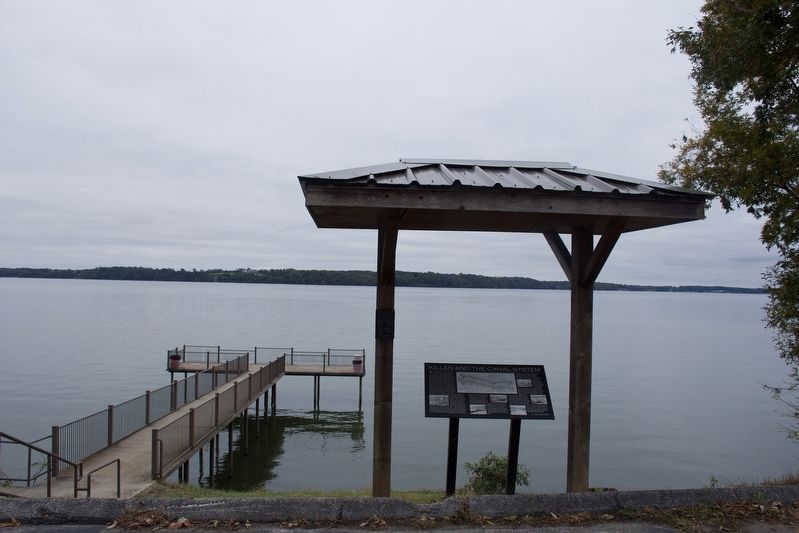
Two hundred feet from where you are, in 40 feet of water, are the remains of Lock Six, the headquarters for a locking system of 9 locks that provided river traffic around the rapids and shoals. The river fall of 136 feet in about 37 miles prevented . . . — — Map (db m141979) HM
On Gates Avenue at Franklin Street S.E. on Gates Avenue.
Before statehood, the Alabama Territory had only limited rights of self government. Between July 5 and August 2, 1819, forty-four delegates from across the Territory convened in Huntsville to draft a constitution for statehood. Lawyers, merchants, . . . — — Map (db m26592) HM
Here, President James Monroe was honored at a public dinner on June 2, 1819, while on a three-day visit to the Alabama Territory. Here, also, the First Alabama Legislature convened on October 25, 1819, while Huntsville was the first Capital. — — Map (db m27851) HM
On North Alabama Avenue (State Road 21), on the left when traveling north.
Created in 1815 by proclamation of Governor of Mississippi Territory from lands ceded by Creek Indians in Treaty of Ft. Jackson, 1814.
Named for President James Monroe, fifth President of U.S.., 1817-25, who purchased Florida from Spain, . . . — — Map (db m47695) HM
On Railroad Street NW at Vine Street NW, on the left when traveling north on Railroad Street NW.
The Old Decatur Historic District dates Back to the town's settlement in 1817; at that time it was called Rhodes Ferry Landing after Dr. Henry W. Rhodes, an early landowner who operated a ferry across the Tennessee River. In 1820, President . . . — — Map (db m103229) HM
On Bank Street NE at Church Street NE on Bank Street NE.
The Old Decatur Historic District dates Back to the Town's settlement in 1817; at that time it was called Rhodes Ferry Landing after Dr. Henry W. Rhodes, an early landowner who operated a ferry across the Tennessee River. In 1820, President . . . — — Map (db m103225) HM WM
Our Constitution names the President of the United States the Commander in Chief of all the Armed Forces. Presidents who have served in our military are displayed on the following plaques. Each has served either on Active Duty, in the National . . . — — Map (db m92382) HM WM
On Atlantic Street at Main Street, on the right when traveling north on Atlantic Street.
Freedom Shrine
Created by the National Exchange Club
to strengthen citizen appreciation
of our American heritage
Presented by the Exchange Club of Stamford
Dedicated June 14, 1979
[ Reproductions of historic American documents are . . . — — Map (db m38610) HM
Near East Street, on the left when traveling south.
Although the United States won the War of 1812, the searing memory of the nation’s capital in flames continued to disturb the public and Congress alike. The British had entered the Chesapeake Bay, continued up the Potomac River, and set fire to . . . — — Map (db m48353) HM
Near 1st Street Northeast south of Maryland Avenue Northeast, on the right when traveling north.
July 4, 1815
The cornerstone of the Old Brick Capitol
built by Washington citizens
to house the Congress
was laid on this site.
The Congress met here from December 13, 1815
through March 3, 1819.
President Monroe was inaugurated here . . . — — Map (db m39411) HM
Near 15th Street Northwest south of Euclid Street Northwest, on the left when traveling north.
President Monroe singed a charter in 1821 that established Columbian College on a site north of Florida Avenue between 14th and 15th Streets, Columbian College moved to Foggy Bottom in 1912 and became George Washington University, but the original . . . — — Map (db m63771) HM
On I Street Northwest west of 20th Street Northwest, on the right when traveling west.
Built in 1802 This house was the home of James Monroe Lieutenant-Colonel in the American Revolution
While Secretary of State and of War under Madison, and for the first six months of his administration as fifth President of the United . . . — — Map (db m97526) HM
On F Street Northwest east of 22nd Street Northwest, on the right when traveling east.
Established on the occasion of the 175th anniversary of the signing of the Charter of The George Washington University by President James Monroe on February 9, 1821 in honor of all who have and all who will contribute to the continued growth and . . . — — Map (db m115024) HM
On I Street Northwest west of 21st Street Northwest, on the right when traveling east.
Dedicated in honor of the Marquis de Lafayette (1757-1834), a hero of the American Revolution, defender of liberty, statesman, and good friend of George Washington.
In 1777 the 20-year old Marie-Joseph-Paul-Yves-Roch-Gilbert du Motier, Marquis . . . — — Map (db m95180) HM
On 21st Street Northwest north of G Street Northwest, on the right when traveling south.
Professors Gate
is dedicated to
The George Washington University faculty
who have guided GW students since 1821
when President James Monroe and
The Congress of the United States chartered this institution.
On the . . . — — Map (db m111545) HM
On Sicard Street Southeast at Dahlgren Avenue Southeast, on the right when traveling south on Sicard Street Southeast.
Marine Railway In 1822 Commodore John Rogers designed and built the first marine railway in the United States. The purpose of the railway was to haul ships out of the water for repair or preservation of their hull. Before this time, ships . . . — — Map (db m10799) HM
On South River Landing Road, 0.5 miles south of Washington Street (U.S. 90), on the right when traveling south.
The first U.S. defeat of the Seminole Wars took place here on November 30, 1817. Several hundred Seminole, Creek and maroon (Black Seminole) warriors came to this site following raids by U.S. troops on the Creek Indian village of Fowltown near . . . — — Map (db m113147) HM
These cannon, which were captured when Lord Cornwallis surrendered at Yorktown in the American Revolution, were a gift to the Chatham Artillery by President George Washington - a mark of his appreciation for the part the local military company . . . — — Map (db m5517) HM
On Bull Street near Oglethorpe Avenue, on the left.
The Independent Presbyterian Church was organized in 1755. The first meeting house stood facing Market Square in Savannah, between what are now St. Julian and Bryan Streets, on property granted by King George II for the use and benefit of those . . . — — Map (db m5515) HM
Johnson Square is named for Governor Robert Johnson of South Carolina who befriended the colonists when Georgia was first settled. It was laid out by Oglethorpe and by Colonel William Bull in 1733, and was the first of Savannah's squares. In early . . . — — Map (db m5494) HM
On River Street near N Barnard Street, on the left when traveling south.
The first steamship to cross the Atlantic Ocean, the SS SAVANNAH, sailed from this harbor on May 22, 1819 and reached Liverpool 27 days later. The anniversary of her sailing, May 22, is celebrated as National Maritime Day. Captain Moses Rogers was . . . — — Map (db m4934) HM
William Scarbrough (1776-1838) was the moving force among the enterprising business men of Savannah who in 1819 sent the first steamship across the Atlantic Ocean. The corporate charter which Scarbrough and his associates obtained from the Georgia . . . — — Map (db m5385) HM
On Martin Luther King Jr. Blvd. (West Broad Street) near West Congress Street, on the left when traveling north.
Designed by noted English architect William Jay,
this house was built for William Scarbrough,
president of the Savannah Steamship Company.
Completed in 1819, it is an excellent example of
the neoclassical style. Scarbrough hosted
President . . . — — Map (db m35303) HM
Hugh Montgomery, born in S.C. Jan. 8, 1769, is buried here. He was employed in 1786 to survey the line between Franklin Co. and the Cherokee Nation. He represented Jackson Co. in the Ga. Legislature in 1807-11 and in the State Senate 1812-18 and . . . — — Map (db m51687) HM
On Veterans Memorial Boulevard (Georgia Route 9) south of Main Street (Georgia Route 20), on the right when traveling south.
The town of Cumming (incorporated 1834) is named in honor of Col. William Cumming, distinguished Georgian, born July 27, 1788, son of Thomas Cumming and Ann Clay, daughter of Joseph Clay, of Savannah. William Cumming graduated from the College of . . . — — Map (db m33581) HM
On George McDuffie Road, 0.5 miles south of Augusta Road (U.S. 278), on the left when traveling south.
From these humble and obscure Georgia pinelands, assisted by the plantation-owning South Carolina Calhouns, George McDuffie rose to become Congressman, Senator, and Governor of South Carolina.
McDuffie's political prominence involved him in a . . . — — Map (db m16065) HM
On South Jackson Street at West Main Street (U.S. 41), on the left when traveling south on South Jackson Street.
Created by Act of May 15, 1821, Monroe County, an original county containing all of Pike and parts of Bibb, Butts and Lamar Counties, was ceded by the Creek Indians in early 1821. Laid out by the Lottery Act, it was rapidly occupied by large numbers . . . — — Map (db m25941) HM
On South Broad Street (Georgia Route 11) 0 miles south of East Washington Street, on the right when traveling north.
This City of Monroe, settled in 1818 and incorporated Nov. 30, 1821, was named for James Monroe, fifth President. Born in Virginia in 1758 he fought in the Continental Army. He served in the Virginia legislature, in Congress and the Senate, and as . . . — — Map (db m20718) HM
On Tavernier Way, 0.2 miles south of West MacArthur Drive (Illinois Route 111/140), on the left when traveling south.
Theodore Roosevelt Letter On Cuba
On January 22, 1907, President Theodore Roosevelt wrote to Secretary of War William Howard Taft rejecting the idea of a protectorate over Cuba and expressing his determination that the United States should . . . — — Map (db m169581) HM
The home is located on Lot 3 of the original plat presented by President Monroe in 1823 as Andersontown by William Conner, son-in-law of Chief Kikthawenund (Chief Anderson). Here Captain John Berry built a log cabin. In 1865 Alfred Makepeace erected . . . — — Map (db m233) HM
Near E. Market Street, 0.2 miles east of S. Allen Street.
A veteran of the Battle of Tippecanoe, General Tipton was apointed to the Indian Agency located in Ft. Wayne Indiana, by President Monroe.
John Quincy Adams appointed Major General Tipton Indian Commissionder to oversee treaties with the Indians . . . — — Map (db m76577) HM
On Old U.S. 81, 0.3 miles south of Comanche Road, on the right when traveling south.
In 1825 President James Monroe approved a bill providing for the survey of the Santa Fe Trail from Missouri to New Mexico and the making of treaties to insure friendly relations with Indians along the route. A mile west of this sign, on Dry Turkey . . . — — Map (db m53059) HM
Near NW Railroad Street near NW Curtis Street, on the left when traveling west.
Delaware, 1st State
December 7, 1787
1609 • Henry Hudson visited Delaware Bay
1638 • Swedish colonists established Fort Christina, Delaware's first permanent settlement, and founded the colony of New Sweden
1655 • Dutch captured New . . . — — Map (db m47214) HM
On Wilkinson Street, on the right when traveling south.
Liberty Hall A National Historic Landmark This Georgian mansion was begun 1796, by John Brown and named for Lexington, Virginia academy he attended. His wife Margaretta and Elizabeth Love began first Sunday School west of Alleghenies in . . . — — Map (db m84387) HM
Born in Dublin he arrived in America c. 1768. Present at 1776 Delaware crossing and battles of Trenton, Princeton, Brandywine, Germantown & Monmouth; wintered 1777-78 at Valley Forge: captured at Charleston 1780 with Lt. Col. Jon. Clark: witnessed . . . — — Map (db m127917) HM
On Louisville Riverwalk just west of Clark Memorial Bridge.
Visitors at Louisville Wharf
James Monroe June 1819 •
Andrew Jackson June 1819 •
Alexis de Tocqueville December 1831 •
Washington Irving September 1832 •
Abraham Lincoln September 1841 •
Charles Dickens April 1842 •
Walt Whitman . . . — — Map (db m83929) HM
The General and Statesman
Isaac Shelby’s military decisions at the Battle of King’s Mountain in 1779 secured a critical victory for America during the Revolutionary War. Before war’s end, Shelby had also served in the North Carolina . . . — — Map (db m120217) HM
Isaac Shelby, soldier, statesman, and surveyor, was Kentucky’s first governor. He served from 1792 to 1796 and was re-elected in 1812.
Shelby came to Kentucky in 1774 when he was hired by the Transylvania Company to survey the new Kentucky . . . — — Map (db m120117) HM
On South Main Street (State Highway 100) at 3rd Street, on the right when traveling north on South Main Street.
The only county of the 2,957 in the United States named for a President where the county seat is named for the contemporary Vice-President. County formed in 1820; named for James Monroe the fifth President, author of the Monroe Doctrine. The county . . . — — Map (db m39401) HM
On South Third Street (U.S. 31E/150), on the right when traveling north.
One of the oldest houses in Bardstown, the west side stone portion has to date from before 1795. On one side of the "settled lots," improved by Samuel Duncan under the lottery terms of settlement, it was the residence of both William Pope Duval and . . . — — Map (db m74288) HM
Near Court Street (County Route 987-4) at Route 987-5.
(panel 1)
Life in Early Nineteenth Century West Baton Rouge…
In 1803, very few Americans lived in West Baton Rouge Parish. It was populated by various Native American tribes; Creoles, who descended from original French and . . . — — Map (db m89070) HM
The idea of a fort on the Penobscot was not new when the U.S. government purchased land for Fort Knox in 1844. The Board of Engineers, established and charged by the Secretary of War to make a plan for the defense of the United States, had listed a . . . — — Map (db m55135) HM
On West Street at Church Circle, on the right when traveling west on West Street.
During winter 1988/89, the area known as Lot 70 in James Stoddert’s 1718 survey will be the site of a historical archeological excavation.
In 1718, this lot was owned by Charles Carroll, grandfather of Charles Carroll of Carrollton, who in 1734 . . . — — Map (db m2860) HM
On Conduit Street near Gorman Street, on the left when traveling south.
Just north of this building, facing Main Street, stood Mann’s Tavern where twelve delegates from five states met in 1786 to discuss commercial problems of the new nation. Their call for another convention in Philadelphia to render the government . . . — — Map (db m130220) HM
The narrow land shaped by Bear Creek, Bread and Cheese Creek, and Back River was the site of the Battle of North Point, September 12, 1814. Some 3,200 Americans clashed with 4,500 British to delay the advance on Baltimore.
When Britain threatened . . . — — Map (db m79747) WM
On St. Leonard Road (Maryland Route 765) 0.1 miles south of Calvert Beach Road, on the right when traveling south.
The History of the St. Leonard Garden of Remembrance (1990 - Present)
The Original Garden
The Road and Garden of Remembrance began in the spring of 1990 as a project of a committee of the St. Leonard Area Citizens Association . . . — — Map (db m181827) HM
Near Teagues Point Road, 0.1 miles south of Fairfax Court.
War of 1812
Great Britain had been at war with France since 1793 and imposed several trade restrictions that the newly formed United States of America found unbearable.
On June 18, 1812, the United States of America declared War on Great . . . — — Map (db m128748) HM
Near Casselman Road, 0.1 miles National Road (Route Alt-40).
Spanning the Cassleman River and supporting 200 years of hooves, boots, sleigh runners, and wheels of every type and description, the Cassleman River Bridge begins its third century on the National Road in Grantsville, Maryland. It is one of the . . . — — Map (db m135702) HM
On National Pike (Route Alt-40) 0.3 miles east of Patton Lane, on the left when traveling east.
Spanning the Casselman River and supporting 200 years of hooves, boots, sleigh runners, and wheels of every type and description, the Casselman River Bridge begins its third century on the National Road in Grantsville, Maryland. It is one of the . . . — — Map (db m167079) HM
On Casselman Road, 0.2 miles west of National Pike (Alternate U.S. 40), on the left when traveling west.
[Side 1]
Gateway to the West
The overarching theme in the Heritage Area is Garrett County's relationship to the opening and development of America's western frontier in the late 18th and early 19th centuries. In fact Garrett County is . . . — — Map (db m223083) HM
On Market Street, 0.1 miles east of North Street, on the left when traveling east.
On August 26, 1814 this house provided shelter for President Madison and his official party during the British burning of the federal buildings in Washington, D.C. in the War of 1812.
The following day, August 27th, the Secretary of State . . . — — Map (db m365) HM
On Aquasco Road at Saint Mary's Church Road, on the right when traveling north on Aquasco Road.
Amid rumors of a large British force on the Patuxent, Secretary of State James Monroe scouted the situation. From heights near Aquasco Mills August 20, 1814, he spotted the enemy vessels landing at Benedict.
Alarmed, Monroe positioned . . . — — Map (db m75347) HM
The Battle of Bladensburg on August 24, 1814, ended in defeat for the United States and allowed the British to invade Washington, D.C. Once the Americans realized the British route of advance, there was little time to prepare. They . . . — — Map (db m61550) HM
On Bladensburg Road (Alternate U.S. 1) east of 40th Avenue.
As the militia – local citizens—defended this road, then known as the Bladensburg or Washington turnpike, from approaching British troops in 1814, three historical figures stood in the thick of the battle at or near this point: . . . — — Map (db m73241) HM
On Bladensburg Road (Alternate U.S. 1) when traveling west.
The Second of three defensive lines blocking the British advance on Washington stretched along here. It was located on the first set of hills overlooking the river. The American militia was unprepared to face seasoned war veterans. Holding firm . . . — — Map (db m69353) HM
On Bladensburg Road (U.S. 1) at 38th Avenue, on the left when traveling south on Bladensburg Road. Reported missing.
The Second of three defensive lines blocking the British advance on Washington stretched along here. It was located on the first set of hills overlooking the river. The American militia was unprepared to face seasoned war veterans. Holding firm . . . — — Map (db m73131) HM
The Louisiana Purchase
Under the direction of President Thomas Jefferson, the Louisiana Purchase of 1803 — the largest single land deal in the history of the United States — doubled the size of the young nation. Napolean Bonaparte of . . . — — Map (db m202672) HM
The Piney Point area possesses its own unique social history and charm. Named for the loblolly and long leaf yellow pines along the shoreline, Piney Point became the social center of Washington D.C. between 1820 and 1910. President James Monroe . . . — — Map (db m94280) HM
On Main Street (U.S. 24) south of 2nd Street, on the left when traveling south.
James Monroe was born at Monroe's Creek, Westmoreland County, Virginia on April 28, 1758 to Scots-Welsh parents. He attended the College of William and Mary in Williamsburg, Virginia but left school to enlist in the Third Virginia Regiment, . . . — — Map (db m149767) HM
On Madison Street at South Riverside Drive, on the right when traveling east on Madison Street.
On the tenth day of August A.D. 1821 the President of the United States proclaimed the admission of Missouri to statehood.
On this spot was located the First State Capitol of Missouri. — — Map (db m169213) HM
Upon invitation of President Monroe, issued at the request of the Congress, Marquis de LaFayette, Revolutionary War hero, revisited the United States for a goodwill tour which included an extensive visit to New Hampshire towns. He passed this spot . . . — — Map (db m77815) HM
On Washington Street (County Route 510), on the left when traveling west.
English by birth French citizen by decree American by adoption Author of The American Crisis Rights of Man The Age of Reason Your presence may remind Congress (and the people) of your past services to this country. —George Washington Left . . . — — Map (db m8551) HM
On East Main Street (U.S. 11) 0.1 miles west of Elm Street (New York State Route 30), on the left when traveling west.
SETTLEMENT On this site, known as 'The Center', the village that became Malone was first settled in 1802. Harison Academy, the first public building, was erected in 1806 on land donated by the community's proprietor, Richard Harison, Esq. In . . . — — Map (db m78997) HM
On Military Road at Hounsfield Street, on the right when traveling north on Military Road.
President
James Monroe
Was Greeted By Survivors Of
Revolution At This Bridge
August 4, 1817. Saluted With
19 Guns At Arrival In Village. — — Map (db m109150) HM
On Main St. W at Fitzhugh St, on the right when traveling east on Main St. W.
Created February 23, 1821 - Named for James Monroe
Born April 28, 1758, Virginia - Died July 4, 1831, New York
Major in the American Revolution - Senator from Virginia
United States Minister to France and England
Twice Governor of Virginia - . . . — — Map (db m57092) HM
Near park path at St. Marks's Place at Avenue A, on the left when traveling east.
This park honors Daniel D. Tompkins (1774–1825), who served as Governor of New York from 1807 to 1817 and as Vice President of the United States under James Monroe (1758-1831) from 1817 to 1825. Peter Stuyvesant (1610–1672), director . . . — — Map (db m145224) HM
On New York State Route 17M at New York State Route 208, on the right when traveling west on State Route 17M.
Created by NYS March 23, 1799
First named Cheescocks, renamed Munroe April 6, 1808, popularized Monroe ca. 1818 after President James Monroe. — — Map (db m23469) HM
On Pollock Street at Middle Street, on the right when traveling west on Pollock Street.
The walls on this site are erected over the brick and ballast stone foundation of the first house of worship of Colonial Craven Parish which was established in 1715. The brick Anglican Church was completed in 1750, and it continued in use until the . . . — — Map (db m24354) HM
On Lighthouse Drive east of East Main Street (Ohio Route 163), on the right when traveling east.
The Marblehead Lighthouse is the oldest lighthouse in continuous operation
on the Great Lakes. Originally known as the Sandusky Bay Light Station,
the lighthouse was built here in 1821 to aid navigation and prevent
shipwrecks. William Kelly . . . — — Map (db m150126) HM
RIVER TOWN
"The settlement of the Ohio country, sir, engrosses many of my thoughts... and if I am to form an opinion on what I have seen and heard on the subject, there are thousands in this quarter who will emigrate to that country." - . . . — — Map (db m21678) HM
On Second Street at St. Clair Street, on the right when traveling south on Second Street.
The Northwest Ordinance, 1787. Following the establishment of the public land system in 1785, the Continental Congress appointed a committee, chaired by James Monroe, to establish government in the new territory north and west of the Ohio . . . — — Map (db m20653) HM
On Williams Road just east of Gossard Drive, on the right when traveling east.
Barnhart Rice Homestead
The Barnhart Rice house is one of two original farmhouses occupying this 320-acre hilltop farmstead from the early days of the settlement. Started in the spring of 1822, the house was built of hand-cut sandstone . . . — — Map (db m66463) HM
On West Indiana Avenue (Ohio Route 65) near Fort Meigs Road, on the right when traveling south.
[Front Side of Marker]: "Amos Spafford"
In 1810, early settlers here were Major Amos Spafford (1753-1818), his wife Olive (1756-1823), and their children Samuel, Aurora , Chloe (Mrs. Almon Gibbs), and Anna (Mrs. Richard Craw). In 1796, . . . — — Map (db m28274) HM
Five panels, one each for Spain, Great Britain, Russia, the United States and Mexico, outline each country's claim to the Oregon territory.
Spain
Vasco Nunez de Balboa first saw the Pacific Ocean in Sept. 1513. Until . . . — — Map (db m87958) HM
Near Aquetong Road, on the right when traveling east.
Headquarters of Brigadier-General Lord Stirling previous to the Battle of Trenton. Quartered with him were Captain William Washington, Lieutenant James Monroe (later President of the United States) and Captain James Moore of the New York Artillery, . . . — — Map (db m13770) HM
On Yellow Springs Road, on the right when traveling west.
Quarters of
Maj. Gen. William Alexander
Lord Sterling
Continental Army
During the Valley Forge
Encampment
December 19, 1777 – June 19, 1778
Maj. James Monroe
Fifth President of the United States
Also quartered here . . . — — Map (db m62396) HM
April 22, 1792 - March 22, 1862
Nissan 30, 5552 - Adar II 20, 5622
"I am an American, a sailor and a Jew."
Born in Philadelphia in 1792, Uriah Phillips Levy was a fifth generation American. According to family stories, he left for . . . — — Map (db m123962) HM
On Market Street at South Independence Mall West (6th Street), on the right when traveling east on Market Street.
A Brief Timeline of Freedom and Slavery at this Site
Before • For hundreds of years, Algonquian-speaking peoples lived here.
1682 • The city of Philadelphia was founded.
1767 • The house was built by Mary Lawrence Masters, a slaveholder . . . — — Map (db m102465) HM
Near Fort Adams Drive, on the left when traveling north.
The Bay Islands Park, managed by the Rhode Island Department of Environmental Management, consists of nine sites that extend from Patience Island in the upper bay to Beavertail and Brenton Point overlooking Rhode Island Sound. Each of the nine . . . — — Map (db m48451) HM
Beaufort 300
We celebrate and recognize the proud citizens
who gave generously to create and erect
these monuments to honor
Beaufort's 300th Birthday
January 17th 2011.
(Plaque 1)
Prior to the founding of . . . — — Map (db m67284) HM
On Broad Street, 0.1 miles west of Church Street, on the left when traveling east.
This handsome building, c. 1800 was constructed by Gilbert Chalmers. From 1810 to 1825 it was the home of Gov. John Geddes, who married the builder's daughter. During Gov. Geddes' term in office, Pres. James Monroe visited here. In 1867 Mary . . . — — Map (db m27514) HM
On Broad Street at Orange Street, on the left when traveling east on Broad Street.
Site of the St. Andrew's Hall
Designed by Hugh Smith
for
the St. Andrew's Society of Charleston, S.C.
founded in 1729,
the oldest benevolent organization in the State of South Carolina
corner stone laid July 4, 1814,
building destroyed . . . — — Map (db m27469) HM
On North Shelmore Blvd. near Faye Lane, on the left when traveling west.
Maybank GreenIn 1697 David Maybank II (1660-1713) acquired 200 acres along Hobcaw Creek from the Lords Proprietors. Maybank, a carpenter, built a house on this site which he named Hobcaw Plantation. The plantation passed to his daughter . . . — — Map (db m37965) HM
On Ocean Highway (U.S. 17) south of Arcadia Plantation Drive.
On his tour south to inspect the defenses of the Atlantic coast, President Monroe reached Prospect Hill, Col. Benjamin Huger’s residence, April 21, 1819. During his stay, April 21-24, he was lavishly entertained by his host and by the citizens and . . . — — Map (db m4870) HM
John C. Calhoun's Plantation Office was his private sanctuary and housed both his study and library during his twenty-five year residency at Fort Hill. In this building Calhoun developed and set forth his most historically significant . . . — — Map (db m9566) HM
On 2nd Avenue South at Mill Creek Drive, on the right when traveling west on 2nd Avenue South.
Glen's Stand was a large log house, inn, and tavern. Built pre-1812 by the Glen family in the Mississippi Territory, it was located on a trail beaten out by buffalos, which became part of (Cherokee Chief) Doublehead Trace. It stood at present-day . . . — — Map (db m146819) HM WM
On Main Street (U.S. 2) at St. Paul Street, on the right when traveling east on Main Street.
Site of the American House 1808-1893 Presidents Monroe, Van Buren, Pierce, Grant
Generals Scott, Wool, Hampton
Henry Clay, and other famous famous people entertained here. — — Map (db m21813) HM
Ash Lawn - Highland
Home of James Monroe from 1799-1823
Dedicated on July 20, 1985
by
Virginia Daughters of the American Revolution
State Regent
Mrs. G.E. Honts, Jr. — — Map (db m63671) HM
On McCormick Road south of University Avenue (Business U.S. 250), on the left when traveling south.
In 1788 James Monroe purchased an 800-acre farm here to be close to his friend Thomas Jefferson and to establish a law office. In 1799 the Monroes moved to their new Highland plantation adjacent to Monticello and sold the first farm. In 1817 the . . . — — Map (db m8762) HM
On University Avenue (Business U.S. 250) at Rugby Road on University Avenue.
Thomas Jefferson founded the University of Virginia. The cornerstone of its first building was laid on October 6, 1817, in the presence of three presidents of the United States—Jefferson, James Madison, and James Monroe. In 1825, the . . . — — Map (db m61101) HM
On Scottsville Road (Virginia Route 20) just south of Carters Mountain Road (Route 627), on the left when traveling south.
Bounded by the James River to the south and the Rivanna River to the north, this nationally significant district encompasses 83,627 acres. Listed on the National Register of Historic Places in 2007, it includes buildings influenced by Jefferson’s . . . — — Map (db m23240) HM
On James Monroe Parkway (County Route 795) 0.8 miles south of Thomas Jefferson Parkway (Virginia Route 53), on the left when traveling south.
This estate was the home of James Monroe, fifth president of the United States. In 1793, James and Elizabeth Kortright Monroe purchased 1,000 acres adjoining Jefferson’s Monticello. Called Highland, the plantation, eventually totaling 3,500 acres, . . . — — Map (db m23437) HM
Near North Union Street east of Fayette Alley, on the right when traveling north. Reported missing.
13,000 years ago
The Paleoindian Period
A Native American hunter during the Paleoindian period discards a broken spear point, on a bluff overlooking a tributary to the Potomac River at the southern edge of present-day Alexandria. . . . — — Map (db m166409) HM
On North Glebe Road (State Highway 120) at 41st Street, on the right when traveling south on North Glebe Road.
Pimmit Run is a stream that runs from the Pimmit Hills neighborhood in Falls Church and joins the Potomac River immediately south of Chain Bridge. The mouth of Pimmit Run provided Native Americans and settlers access to fresh water and fishing, the . . . — — Map (db m59708) HM
On Richmond Highway (U.S. 301) 3 miles south of Dawn Boulevard (Virginia Route 30), on the right when traveling south.
On 24 Aug. 1800, slave Ben Woolfolk met with other slaves at nearby Littlepage’s Bridge to recruit individuals for an insurrection planned for 30 Aug. The insurgents led by Gabriel, a slave owned by Thomas Henry Prosser of Henrico County, intended . . . — — Map (db m5611) HM
On 5th Street NE at East Market Street, on the left when traveling south on 5th Street NE.
In 1789 James Monroe moved to Charlottesville and for one year his home was located in the first block west of this site. Then he lived for nine years in the home he built on what is now called “Monroe Hill” at the University of . . . — — Map (db m19808) HM
On East Market Street west of 5th Street NE, on the right when traveling east.
George Nicholas, Albemarle County’s Virginia General Assembly delegate in 1783, built a stone house here in 1784. James Monroe occupied it 1789-1790, while improving the dwelling at his nearby farm, later the site of the University of Virginia. Here . . . — — Map (db m19830) HM
On Jefferson Park Avenue east of Emmet Street (Business U.S. 29), on the right when traveling east.
Fernando Bolívar, a native of Venezuela, attended the University of Virginia in 1827. He was the nephew and adopted son of Símon Bolívar, The Liberator, who sent him to study in the “Republic of Washington and Jefferson.” A friend of . . . — — Map (db m8820) HM
On Park Street at East Jefferson Street on Park Street.
To the memory and service of three Presidents of the United States
Thomas Jefferson, James Madison and James Monroe
associated with this courthouse in Albemarle County, Virginia — — Map (db m170128) HM
161 entries matched your criteria. The first 100 are listed above. The final 61 ⊳