On 2nd Street Southeast just north of M Street Southeast, on the right when traveling north. Reported permanently removed.
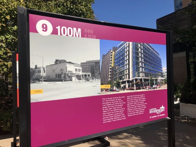
Prior to the plot of land at the corner of 1st and M Streets, SE being purchased by Opus East, the On Luck Cafeteria and Zohery Bus Tours garage were open and operating for many years. Open since the 1960s, On Luck Cafeteria served up fried chicken . . . — — Map (db m141563) HM
On 2nd Street Southeast just north of M Street Southwest, on the right when traveling north. Reported permanently removed.
1015 Half Street is a 421,000 square-feet Class A office building originally started by OPUS East but finished by Skanska and now owned by Prudential. Started in 2008, the building stood as a vacant shell through much of the Great Recession until it . . . — — Map (db m141556) HM
Near Water Street Southeast west of 4th Street Southeast, on the left when traveling west. Reported permanently removed.
The parcel on which 1221 Van is located was once the site of a much frequented gas station at the corner of South Capitol and N Streets, which operated until late 2007. Once owned by Monument Realty and Lehman Brothers, the site was purchased by the . . . — — Map (db m141573) HM
On 2nd Street Southeast just north of M Street Southeast, on the right when traveling north. Reported permanently removed.
Once a paper warehouse and printing facility for The Washington Post, 200 I Street also served as a "tech hotel" before it was ultimately repurposed as a Class A office space that houses four DC Government agencies. The renovation and . . . — — Map (db m141559) HM
On 2nd Street Southeast just north of M Street Southeast, on the right when traveling north. Reported permanently removed.
909 Capitol Yards is one of three residential apartment buildings constructed in Capitol Riverfront by developer JPI. The 237-unit building opened in 2011 on New Jersey Avenue, an area of the neighborhood populated by low commercial building, auto . . . — — Map (db m141565) HM
On Water Street Southeast west of 4th Street Southeast, on the left when traveling west. Reported permanently removed.
The parcel of land on which 99M—a 220,000 square-feet LEED Platinum Class A Office building—is set was once the site of Normandie Liquors. According to JDLand.com, Normandie Liquors "seemed to become a symbol of old versus new" in the neighborhood, . . . — — Map (db m141572) HM
Near Water Street Southeast west of 4th Street Southeast, on the left when traveling west. Reported permanently removed.
Opened in July 2018, Audi Field is the home for the D.C. United professional soccer team. Located in Buzzard Point of Capitol Riverfront, Audi Field was a public-private partnership between the District Government and the ownership of D.C. United to . . . — — Map (db m141578) HM
On 2nd Street Southeast just north of M Street Southeast, on the right when traveling north. Reported permanently removed.
Built on the site of the historic Washington Canal, Canal Park is three blocks of vibrant urban space with seasonal ice skating, interactive water fountains, and larger-than-life sculptures. Historically, the park draws its name from the Washington . . . — — Map (db m141549) HM
On 2nd Street Southeast just north of M Street Southeast, on the right when traveling north. Reported permanently removed.
Constructed by EYA in partnership with the DC Housing Authority, these 327 townhomes are part of the rebuild of the Arthur Capper Carrollsburg public housing complex. The earlier 707 housing units were demolished in 2005 and these homes are a blend . . . — — Map (db m141554) HM
Near Water Street Southeast west of 4th Street Southeast, on the left when traveling west. Reported permanently removed.
Voted by DC residents as Best Apartment Building in Washington City Paper's 2018 "Best of DC" poll, Dock 79 sits on once-neglected riverfront land that was used by land owner Florida Rock Properties for concrete mixing and gravel storage. Florida . . . — — Map (db m141575) HM
On 2nd Street Southeast just north of M Street Southeast, on the right when traveling north. Reported permanently removed.
Today, the Homewood Suites by Hilton at 50 M Street, SE features rooftop views and two of DC's most popular fast casual restaurants — CAVA and Shake Shack. The land on which the hotel sits included a Sunoco gas station until 2006 when the station . . . — — Map (db m141561) HM
On 2nd Street Southeast just north of M Street Southeast, on the right when traveling north. Reported permanently removed.
Once a quiet block that served as an entrance to the Navy Yard-Ballpark Metro station, mixed-use residential building Insignia on M now sits on a bustling corner of the Capitol Riverfront neighborhood. St. Matthews Baptist Church, built in 1972, . . . — — Map (db m141567) HM
Near Water Street Southeast just west of 4th Street Southeast, on the left when traveling west. Reported permanently removed.
Nationals Park opened in April 2008 as the 42,000 seat home for the Washington Nationals Baseball Club and a catalyst for the Capitol Riverfront and the Anacostia Waterfront Initiative (AWI) framework Plan. Situated on 17 acres of land, Nationals . . . — — Map (db m182141) HM
On 2nd Street Southeast just north of M Street Southeast, on the right when traveling north. Reported permanently removed.
For many years, the land on which One Hill South now exists was the site of an Exxon gas station, a Wendy's fast food restaurant, and a towing company. The gas station closed in 2006 following a fraud scandal, and the Wendy's location stayed open . . . — — Map (db m141552) HM
Near Water Street Southeast west of 4th Street Southeast, on the left when traveling west. Reported permanently removed.
Formerly the site of the Arthur Capper Senior Citizens Facility, the Bixby was completed in 2016 as part of the Arthur Capper Carrollsburg HOPE VI redevelopment and includes a mix of affordable and market rate apartments. The senior center . . . — — Map (db m141581) HM
On 2nd Street Southeast just north of M Street Southeast, on the right when traveling north. Reported permanently removed.
The Collective is a group of three highly-amenitized apartment buildings including the completed Park Chelsea and Agora, and The Garrett which is set to deliver in 2020. Long before developer WC Smith broke ground on these luxury apartments, the . . . — — Map (db m141562) HM
Near Water Street Southeast just west of 4th Street Southeast, on the left when traveling west. Reported permanently removed.
An original historic structure from the Washington Navy Yard campus, the Lumber Shed building was a concrete, open air structure that was used for the storage and drying of wood to make molds for ship construction. The building was renovated and . . . — — Map (db m141583) HM
Near Water Street Southeast west of 4th Street Southeast, on the left when traveling west. Reported permanently removed.
This mixed-use residential building is situated on what was formerly part of the Navy Yard annex, an expansion of the Washington Navy Yard in response to production required for Navy shipbuilding in World Wars I and II. Developed by Forest City . . . — — Map (db m141582) HM
Near Water Street Southeast just west of 4th Street Southeast, on the left when traveling west. Reported permanently removed.
The United States Department of Transportation (USDOT) building is a two million square-feet office building that is home to the Secretary of the DOT and approximately 7,000 employees. Comprised of two office building and an underground connecting . . . — — Map (db m141579) HM
Near Water Street Southeast west of 4th Street Southeast, on the left when traveling west. Reported permanently removed.
The site of Yards Park was former Navy Yard lands that were vacant and fenced off from the public since the 1890s. Yards Park now is a 5.5 acre award winning public park maintained and operated by the Capitol Riverfront BID on behalf of the DC . . . — — Map (db m141570) HM